Area Overview for B45 8DW
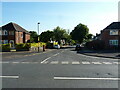
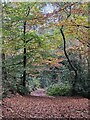
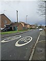
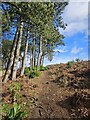
Photos of B45 8DW


Area Information
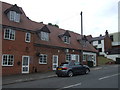
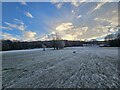
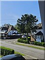
Living in B45 8DW, a small residential cluster in Birmingham’s south-west, offers a quiet suburban lifestyle within the larger Rubery & Rednal ward. The area is part of the Birmingham Northfield constituency, with a population of 1,488 residents. Its proximity to the Lickey Hills, a historic natural feature, provides a contrast to the suburban character shaped by 1960s urbanisation on former sandstone quarries and clay pits. The ward’s older age profile, with a median age of 47, suggests a community rooted in long-term residency. Daily life here is defined by proximity to retail hubs like Tesco Birmingham and Farmfoods Rubery, as well as rail links to Longbridge and Northfield stations. The area’s history includes medieval hedgerows and 19th-century public access to the hills, blending heritage with modern convenience. While the population is predominantly White, the community’s demographic makeup reflects a lower share of BAME residents compared to Birmingham’s average. For those seeking a balance between suburban tranquillity and city connectivity, B45 8DW offers a distinct, compact living environment.
- Area Type
- Postcode
- Area Size
- Not available
- Population
- 1488
- Population Density
- 1636 people/km²
The property market in B45 8DW is characterised by a 54% home ownership rate, suggesting a modest balance between owner-occupied homes and rental properties. The area’s accommodation type is predominantly houses, which is typical of suburban zones with low-rise, family-oriented housing. This contrasts with city-centre areas where flats dominate. Given the small population and limited land area, the housing stock is likely constrained, with fewer new developments compared to larger urban areas. The focus on houses may appeal to buyers seeking space and privacy, though the market’s size means competition for properties could be fierce. Proximity to the M5 motorway and rail stations adds to the area’s appeal for commuters, but the lack of major employment hubs nearby may influence property values. Buyers should consider the limited scope for expansion in this small postcode, as the surrounding areas are similarly developed.
House Prices in B45 8DW
No properties found in this postcode.
Energy Efficiency in B45 8DW
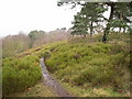
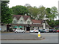
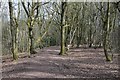
Residents of B45 8DW have access to a range of amenities within practical reach, including retail outlets like Tesco Birmingham, Farmfoods Rubery, and Co-op Rubery, ensuring everyday shopping needs are met. The area’s proximity to the Lickey Hills offers opportunities for walking, cycling, and outdoor recreation, with notable sites such as Rednal Hill and Pinfield Wood. Local parks, including Callowbrook Park and St Chads Park—former clay pits and quarries—provide green spaces for relaxation. The historic medieval hedge along Lickey Road adds a unique character to the landscape. While dining options are not explicitly listed, the presence of nearby retail and leisure facilities suggests a convenient lifestyle. The combination of natural beauty, suburban tranquillity, and accessible transport makes daily life in B45 8DW both practical and enjoyable for residents.
Amenities
Schools
| Rank | School | Type | Entry gender | Ages |
|---|
Explore more schools in this area
Go to Schools tabDemographics
The community in B45 8DW has a median age of 47, with the most common age range being adults aged 30–64. This suggests a mature population, likely with established careers and family ties. Home ownership stands at 54%, indicating a mix of owner-occupied and rental properties, though the latter is not explicitly quantified. The area’s accommodation is predominantly houses, reflecting a suburban layout rather than high-density living. The predominant ethnic group is White, with no specific data provided on the proportion of BAME residents. This demographic profile aligns with the ward’s character as a historically developed area with limited recent migration. The older age group may influence local services and amenities, such as healthcare and leisure facilities, though no specific data on deprivation or income levels is available. The absence of detailed diversity statistics means the community’s cultural composition remains less defined compared to more ethnically varied parts of Birmingham.
Household Size
Accommodation Type
Tenure
Ethnic Group
Religion
Household Composition
Age
Household Deprivation
NS-SEC
Explore more demographic insights in this area
Go to Demographics tabPlanning
Planning Constraints
- Flood RiskPremium
- Ramsar Wetland SitesPremium
- Area of Outstanding Natural BeautyPremium
- Protected Nature ReservePremium
- Protected WoodlandPremium