Area Overview for B44 9HT
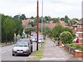
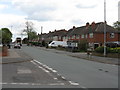
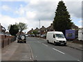
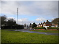
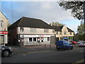
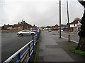
Photos of B44 9HT


Area Information
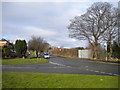
Living in B44 9HT means residing in a small, defined postcode area within the Perry Barr district of Birmingham. This suburban housing estate, developed in the 1930s and 1940s on former farmland, sits near areas like Perry Beeches, Queslett, and Great Barr. The area is characterised by its historical roots, including Old Oscott, a site central to English Catholicism since the 18th century. With a population of 1,557, the community is compact, offering a mix of residential tranquillity and proximity to urban amenities. Residents benefit from nearby green spaces such as Aldridge Road Recreation Ground and Kingstanding Circle, while the area’s history includes landmarks like the Sacred Heart Chapel and associations with figures like John Henry Newman. B44 9HT is ideal for those seeking a settled, low-density environment with historical depth, though its small size means the surrounding areas often supplement daily life. The postcode’s location near major transport routes, including multiple railway stations, ensures connectivity without the congestion of central Birmingham.
- Area Type
- Postcode
- Area Size
- Not available
- Population
- 1557
- Population Density
- Not available
The property market in B44 9HT is dominated by owner-occupied homes, with 63% of residents living in properties they own. This contrasts with areas where rental markets dominate, suggesting a community of long-term residents rather than transient tenants. The accommodation type is primarily houses, which aligns with the suburban character of the area. This housing stock likely includes semi-detached and detached homes, typical of post-war housing estates. Given the small size of the postcode area, the property market may be limited in scope, with buyers needing to consider nearby neighbourhoods for more options. The emphasis on owner-occupation implies stable property values and a focus on long-term investment rather than short-term rental returns. For buyers, this means a market that prioritises security and permanence, though the limited number of properties may require flexibility in search criteria.
House Prices in B44 9HT
No properties found in this postcode.
Energy Efficiency in B44 9HT
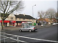
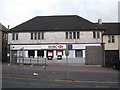
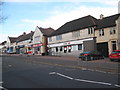
Residents of B44 9HT have access to a range of local amenities within practical reach. Retail options include Spar, Morrisons Daily Great Barr 921, and Asda Queslett, offering everyday shopping needs. The area’s proximity to railway stations like Hamstead and Perry Barr, as well as metro stops such as Soho Benson Road, ensures easy access to public transport for commuting or leisure. While the data does not specify parks or recreational facilities, nearby spaces like Aldridge Road Recreation Ground suggest opportunities for outdoor activities. The mix of retail, transport, and green spaces creates a functional lifestyle, balancing convenience with suburban tranquillity. For those who prioritise accessibility, the cluster of amenities and transport links makes daily life efficient, though the area’s small size means some services may require a short trip to adjacent neighbourhoods.
Amenities
Schools
The nearest school to B44 9HT is Sundridge Primary School, which serves the local community with a primary education offering. It holds an Ofsted rating of ‘good’, indicating a satisfactory standard of teaching and facilities. While no secondary schools are listed in the data, the presence of a primary school with a positive rating is a key consideration for families. The school’s location within practical reach of residents means it is accessible for daily commuting, reducing the need for long journeys. However, families requiring secondary education may need to look beyond the immediate area, as no higher-level schools are mentioned. The availability of a ‘good’ primary school supports the area’s appeal for households with young children, though the absence of secondary options could be a limitation for some buyers.
| Rank | School | Type | Entry gender | Ages |
|---|
Explore more schools in this area
Go to Schools tabDemographics
The population of B44 9HT has a median age of 47, with the majority of residents aged between 30 and 64. This suggests a community skewed towards middle-aged adults, likely including families and professionals. Home ownership stands at 63%, indicating a stable, long-term resident base rather than a transient rental market. The area is predominantly composed of houses, reflecting a suburban rather than high-density residential profile. The predominant ethnic group is White, though no specific diversity statistics are provided. The age profile and ownership figures imply a mature, established community with fewer young families or students compared to other parts of Birmingham. With no data on deprivation levels, it is unclear how economic challenges might affect quality of life, but the high home ownership rate suggests a generally secure financial environment.
Household Size
Accommodation Type
Tenure
Ethnic Group
Religion
Household Composition
Age
Household Deprivation
NS-SEC
Explore more demographic insights in this area
Go to Demographics tabPlanning
Planning Constraints
- Flood RiskPremium
- Ramsar Wetland SitesPremium
- Area of Outstanding Natural BeautyPremium
- Protected Nature ReservePremium
- Protected WoodlandPremium
- Crime RiskPremium