Area Overview for B42 2DW
Photos of B42 2DW


Area Information
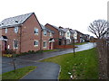
B42 2DW is a specific postcode covering a small residential cluster of 1.1 hectares in the Perry Barr urban district. Approximately 1,553 people inhabit this tightly packed neighbourhood, creating a high population density of 145,762 people per square kilometre. This compact size defines daily life here, where residents navigate close proximity to their neighbours and local facilities. The area sits in north Birmingham, forming part of the larger suburban commune that historically evolved from two separate manors recorded in the Domesday Book. Perry Barr derives its name from the Old English word for pear tree combined with the Celtic term for hill top. While the area was once a chapelry in Handsworth, it became a separate civil parish in 1894 before merging fully with Birmingham on 1 October 1930. Today, the postcode represents a slice of this rich history that remains integrated into the metropolitan borough of the West Midlands. Living in B42 2DW means engaging with a community that carries deep roots stretching back to the 19th and early 20th centuries. The physical layout supports a lived-in feel typical of established suburbs where planning constraints like protected woodlands or wetland sites do not influence the current housing stock. Residents enjoy a straightforward environment free from significant flood risks or nature reserve restrictions. This straightforward profile makes the area practical for those seeking established housing within a compact, well-defined geographical boundary.
- Area Type
- Postcode
- Area Size
- 1.1 hectares
- Population
- 1553
- Population Density
- 5992 people/km²
The property market in B42 2DW is defined by a housing stock consisting entirely of houses. A striking 75% of residents own their homes, indicating a robust owner-occupied market rather than a rental-heavy area. This high level of ownership reflects an established community where families have taken root over generations. The accommodation type data confirms that you will find detached or semi-detached properties rather than high-rise apartments or flat complexes. When looking at homes in B42 2DW, expect traditional suburban architecture suited to the local climate and lifestyle. The small area size of 1.1 hectares limits the volume of properties available within the immediate postcode boundary. Consequently, serious buyers often need to cast their nets slightly wider to access a full selection of properties. The surrounding Perry Barr district offers additional options that maintain the same house-focused character found in this specific cluster. The lack of apartments or flats means this postcode does not cater to high-density urban living. Instead, it supports a low-rise residential model where gardens and private outdoor space likely form a central part of daily life. This market structure appeals to those seeking privacy and the traditional layout of a house on a plot of land. The dominance of owner-occupiers also suggests stable property values and a local economy driven by homeownership finance rather than speculative investment.
House Prices in B42 2DW
Showing 41 properties
| Address | Type | Beds | Baths | Last Sale Price | Last Sale Date | |
|---|---|---|---|---|---|---|
| 15 Longstone Road, Birmingham, B42 2DW | Terraced | 2 | 1 | £165,000 | Dec 2025 | |
| 17 Longstone Road, Birmingham, B42 2DW | house | - | - | £193,300 | Feb 2025 | |
| 73 Longstone Road, Birmingham, B42 2DW | house | - | - | £220,000 | Oct 2022 | |
| 51 Longstone Road, Birmingham, B42 2DW | Terraced | 2 | 1 | £135,000 | Feb 2019 | |
| 55 Longstone Road, Birmingham, B42 2DW | Terraced | 2 | 1 | £142,000 | Sep 2018 | |
| 83 Longstone Road, Birmingham, B42 2DW | Semi-detached | 3 | 1 | £154,000 | Jul 2018 | |
| 29 Longstone Road, Birmingham, B42 2DW | Terraced | 3 | 1 | £132,000 | Jun 2018 | |
| 49 Longstone Road, Birmingham, B42 2DW | Terraced | 2 | 1 | £135,000 | Jan 2018 | |
| 21 Longstone Road, Birmingham, B42 2DW | Terraced | 2 | 1 | £110,000 | Feb 2016 | |
| 63 Longstone Road, Birmingham, B42 2DW | Terraced | 3 | 1 | £124,950 | Oct 2014 |
Energy Efficiency in B42 2DW
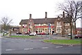
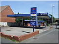
Living in B42 2DW provides convenient access to retail, transport, and leisure facilities within practical reach. Five retail venues operate nearby, including Co-op Walsall, Co-op Dyas, and Lidl Birmingham. These shops offer essential groceries and daily necessities without requiring long journeys into the city centre. For commuters, five railway stations serve the area, specifically Hamstead, Perry Barr, and Witton Railway Stations. Additionally, five metro stops such as Soho Benson Road and Handsworth Booth Street provide integrated transport links. The history of Perry Barr includes notable landmarks like the Birmingham Crematorium at 389 Walsall Road, which holds historical significance regarding World War veterans. The original Odeon cinema, opened by Oscar Deutsch in the 1920s, now functions as a conference venue. Nearby public services include the Tower Hill Library, which is comparable to the former Birchfield Community Library that served the area prior to its demolition in 2007. Sports enthusiasts might recall the Perry Barr Stadium on Aldridge Road, which hosted greyhound racing and speedway teams before its closure. Residents can engage with local heritage while accessing modern amenities. Dining options and leisure activities are supported by the presence of major superstores and transport hubs. The cluster of five shops and five railway connections ensures you have everything required for daily errands without excessive travel time. This blend of historical context and functional convenience defines the local lifestyle.
Amenities
Schools
| Rank | School | Type | Entry gender | Ages |
|---|
Explore more schools in this area
Go to Schools tabDemographics
The community profile for B42 2DW reflects a mature population with a median age of 47 years. Most residents are adults aged between 30 and 64 years, indicating a neighbourhood dominated by established households rather than young families or retirees. Accommodation in this postcode consists entirely of houses, suggesting low-rise residential architecture typical of suburban developments. Home ownership stands at a high rate of 75%, meaning three out of every four residents own their property outright or with a mortgage. The predominant ethnic group in the area is White, which aligns with the broader demographic makeup of established suburbs in the West Midlands. There are no requirements or permissions needed for Ramsar wetland sites, Areas of Outstanding Natural Beauty, protected nature reserves, or protected woodland within this 1.1 hectare boundary. These planning constraints remain non-existent, allowing for standard residential use without environmental restrictions. The absence of such protected statuses simplifies local governance while maintaining the character of a conventional housing estate. For potential buyers, the high home ownership percentage signals a stable, established neighbourhood where residents have likely lived for decades. The age profile suggests a mix of grown-up professionals and empty nesters rather than a transient student market. This demographic stability often correlates with quieter streets and a focus on long-term community investment rather than rapid turnover.
Household Size
Accommodation Type
Tenure
Ethnic Group
Religion
Household Composition
Age
Household Deprivation
NS-SEC
Explore more demographic insights in this area
Go to Demographics tabPlanning
Planning Constraints
- Flood RiskPremium
- Ramsar Wetland SitesPremium
- Area of Outstanding Natural BeautyPremium
- Protected Nature ReservePremium
- Protected WoodlandPremium