Area Overview for B42 1NU
Photos of B42 1NU
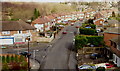
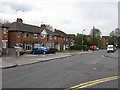
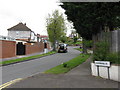
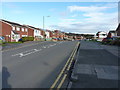
27 photos from this area
Area Information
Key information about the B42 1NU including its size, population, and administrative classification.
- Area Type
- Postcode
- Area Size
- 2.1 hectares
- Population
- 1472
- Population Density
- 4837 people/km²
House Prices in B42 1NU
30
Properties
£150,139
Average Sold Price
£102,950
Lowest Price
£238,000
Highest Price
Showing 30 properties
| Address | Type | Beds | Baths | Last Sale Price | Last Sale Date | |
|---|---|---|---|---|---|---|
| 12 Almond Croft, Birmingham, B42 1NU | Terraced | 3 | 1 | £195,000 | Aug 2025 | |
| 22 Almond Croft, Birmingham, B42 1NU | Terraced | 3 | 1 | £238,000 | Oct 2024 | |
| 30 Almond Croft, Birmingham, B42 1NU | house | 3 | 1 | £190,000 | Feb 2024 | |
| 33 Almond Croft, Birmingham, B42 1NU | Terraced | 3 | 1 | £224,950 | Dec 2023 | |
| 18 Almond Croft, Birmingham, B42 1NU | house | 4 | - | £125,000 | Dec 2017 | |
| 34 Almond Croft, Birmingham, B42 1NU | Terraced | 3 | 1 | £128,050 | May 2017 | |
| 20 Almond Croft, Birmingham, B42 1NU | house | - | - | £130,000 | Nov 2016 | |
| 14 Almond Croft, Birmingham, B42 1NU | Terraced | 3 | 1 | £117,000 | May 2016 | |
| 35 Almond Croft, Birmingham, B42 1NU | house | 3 | 1 | £119,000 | Aug 2010 | |
| 16 Almond Croft, Birmingham, B42 1NU | Terraced | - | - | £125,000 | Mar 2007 |
Page 1 of 3
Energy Efficiency in B42 1NU
Amenities
Schools
| Rank | School | Type | Entry gender | Ages |
|---|
Explore more schools in this area
Go to Schools tabDemographics
Household Size
Family (3-5 people)
most common
Accommodation Type
Houses
most common
Tenure
60
majority
Ethnic Group
White
most common
Religion
N/A
most common
Household Composition
N/A
most common
Age
47
median
Adults (30-64 years)
most common
Household Deprivation
N/A
with no deprivation
NS-SEC
23
in Lower managerial occupations
Explore more demographic insights in this area
Go to Demographics tabPlanning
Planning Constraints
- Flood RiskPremium
- Ramsar Wetland SitesPremium
- Area of Outstanding Natural BeautyPremium
- Protected Nature ReservePremium
- Protected WoodlandPremium