Area Overview for B37 5WA
Photos of B37 5WA

Area Information
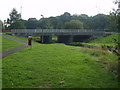
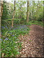
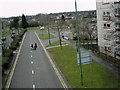
Living in B37 5WA means residing within a specific residential cluster of 1,881 people located in Chelmsley Wood. This post-war settlement, originally built by Birmingham City Council in the late 1960s and early 1970s, stands as a distinct part of the Metropolitan Borough of Solihull. The area centres around ancient woodland that was formerly part of the Forest of Arden before becoming a council estate to rehouse families from Birmingham. You are stepping into a environment defined by its late 20th-century rapid development, which transformed a landscape of open heath into a densely populated community. The layout follows Radburn principles, creating pedestrian pathways between homes and open green spaces without fences. This design choice was notable enough to earn architectural awards for its landscaping. Your daily life here involves interaction with a town centre that hosts 70 shop units and six major retailers. You will find yourself surrounded by facilities opened in the early 1970s, including a library and a community hall that serve the local population. This postcode covers a small area where modern infrastructure meets decades of established history. The urban environment is completey integrated with nearby transport links and commercial hubs. Residents experience daily life shaped by the original vision of this overspill estate, which prioritised grouping houses around landscaped parks.
- Area Type
- Postcode
- Area Size
- Not available
- Population
- 1881
- Population Density
- 4000 people/km²
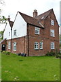
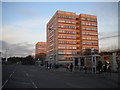
Real estate in B37 5WA is characterised by a specific blend of legacy housing and modern family needs. The accommodation stock is predominantly filled with houses, reflecting the original construction plan for 15,590 dwellings across the estate. Only 39 multi-storey blocks of flats make up the apartment element of this large residential cluster. With home ownership standing at just 36%, this is an area where rental inventory might change hands more frequently than in exclusive private estates. Buyers looking for homes in B37 5WA should expect a variety of properties constructed during the post-war expansion of the 1960s and 1670s. The town centre itself contains 70 shop units and six major stores, creating a commercial hub that services the surrounding housing. This density means you are living in a bustling part of North Solihull that supports a mix of first-time buyers and established families. The presence of 32 town council established governance suggests a community that cares about local preservation. If you are an investor, the high turnover potential linked to the low ownership rate presents specific opportunities. For family buyers, the abundance of houses offers options for larger gardens that are less common in the multi-storey sections. The property market here reflects the practical reality of a functional, working-class community rather than a luxury enclave.
House Prices in B37 5WA
No properties found in this postcode.
Energy Efficiency in B37 5WA
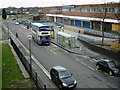
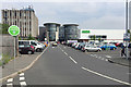
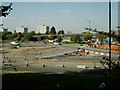
Your lifestyle in B37 5WA revolves around a mature town centre with significant retail capacity. You have five main shopping destinations nearby, including Iceland Chelmsley, Heron Chelmsley, and Asda Chelmsley. These hypermarkets provide ample choice for weekly groceries and household essentials. The area also hosts two pubs, offering local meeting places for residents to socialise.five major stores and the 70 shop units in the town centre create a comprehensive local high street experience. Travel links are equally convenient, with five railway stations operating in the immediate vicinity. You can reach Marston Green, Lea Hall, and Water Orton stations for daily commuting. Furthermore, Birmingham International Airport and Birmingham International Railway Station are both accessible, offering quick journeys to London and Bristol. This connectivity means you do not need to travel far for major supermarkets or train connections. The estate also features open green spaces, continuing the Radburn principle of separating pedestrians from traffic. These parks provide areas for walking, dog exercise, and exposure to the historic woodland heritage. With a library and community hall completed in 1970, cultural activities remain central to the area. The presence of these amenities ensures that you can shop, eat, and travel without leaving the sub-region.
Amenities
Schools
Families living in B37 5WA have access to a range of educational facilities, though the immediate vicinity focuses on one key institution. The City Technology College stands as the primary secondary school serving the local catchment. This academy status provider caters to students transitioning from local primary education. While the data does not specify the Ofsted rating for this school, its establishment as a City Technology College indicates a focus on technical and scientific curriculum alongside standard academic subjects. Living in B37 5WA means your children will likely walk to or bus to this specific secondary provider. The presence of a dedicated town centre and library suggests a community that values education infrastructure. The school location aligns with the wider neighbourhood plan that prioritises family amenities. If you are moving here, you should verify the current catchment boundaries for The City Technology College with the local authority. The educational landscape is straightforward in this postcode, with this secondary school acting as the central pillar for local youth education. The mix of a single named secondary option implies that private schools or other secondary institutions serve students via bus routes or further travel.
| Rank | School | Type | Entry gender | Ages |
|---|---|---|---|---|
| 1 | The City Technology College | secondary | N/A | N/A |
Explore more schools in this area
Go to Schools tabDemographics
The community in B37 5WA is defined by a demographic profile where the median age sits at 47 years. Most residents fall into the adult age range between 30 and 64 years, indicating a population focused on careers and raising families. You are looking at a settlement where the predominant ethnic group identifies as White. With a home ownership rate of 36%, a significant portion of residents rent their properties or own them through shared ownership schemes. This lower percentage suggests a market where you might encounter both landlords and social housing tenants living alongside private homeowners. The area predominantly consists of houses rather than high-density flats, despite the presence of some multi-storey blocks from the original construction. This mix of accommodation types supports a middle-aged workforce that requires sturdier, long-term housing solutions. The demographic data paints a picture of stability, with the majority of the population having settled here for the long term. This adult-heavy profile often translates into quieter streets during evenings, though the concentration of families using younger portions of the adult range ensures local schools and activities remain in use. You can expect a neighbourhood where life is centred on work, family, and community engagement rather than transient living patterns.
Household Size
Accommodation Type
Tenure
Ethnic Group
Religion
Household Composition
Age
Household Deprivation
NS-SEC
Explore more demographic insights in this area
Go to Demographics tabPlanning
Planning Constraints
- Flood RiskPremium
- Ramsar Wetland SitesPremium
- Area of Outstanding Natural BeautyPremium
- Protected Nature ReservePremium
- Protected WoodlandPremium
- Crime RiskPremium