Area Overview for B36 9SB
Photos of B36 9SB
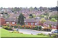
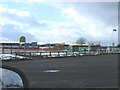
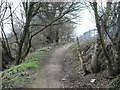
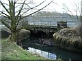
46 photos from this area
Area Information
Key information about the B36 9SB including its size, population, and administrative classification.
- Area Type
- Postcode
- Area Size
- 2.8 hectares
- Population
- 1427
- Population Density
- 2334 people/km²
House Prices in B36 9SB
12
Properties
£257,143
Average Sold Price
£116,500
Lowest Price
£350,000
Highest Price
Showing 12 properties
| Address | Type | Beds | Baths | Last Sale Price | Last Sale Date | |
|---|---|---|---|---|---|---|
| 88 Kingsleigh Drive, Castle Bromwich, Solihull, B36 9SB | Detached | 4 | - | £285,000 | Jul 2016 | |
| 84 Kingsleigh Drive, Castle Bromwich, Solihull, B36 9SB | Detached | 4 | 2 | £265,000 | May 2016 | |
| 82 Kingsleigh Drive, Castle Bromwich, Solihull, B36 9SB | Detached | 4 | - | £342,000 | May 2015 | |
| 47 Kingsleigh Drive, Castle Bromwich, Solihull, B36 9SB | Detached | 4 | - | £350,000 | May 2013 | |
| 90 Kingsleigh Drive, Castle Bromwich, Solihull, B36 9SB | Detached | 3 | 1 | £265,000 | May 2006 | |
| 45 Kingsleigh Drive, Castle Bromwich, Solihull, B36 9SB | Detached | - | - | £176,500 | Jan 2002 | |
| 86 Kingsleigh Drive, Castle Bromwich, Solihull, B36 9SB | Detached | 3 | 1 | £116,500 | Nov 1999 | |
| 43 Kingsleigh Drive, Castle Bromwich, Solihull, B36 9SB | Detached | 4 | 3 | - | - | |
| 41 Kingsleigh Drive, Castle Bromwich, Solihull, B36 9SB | Detached | - | - | - | - | |
| 92A Kingsleigh Drive, Castle Bromwich, Solihull, B36 9SB | Detached | - | - | - | - |
Page 1 of 2
Energy Efficiency in B36 9SB
Amenities
Schools
| Rank | School | Type | Entry gender | Ages |
|---|
Explore more schools in this area
Go to Schools tabDemographics
Household Size
Two person
most common
Accommodation Type
Houses
most common
Tenure
88
majority
Ethnic Group
White
most common
Religion
N/A
most common
Household Composition
N/A
most common
Age
47
median
Adults (30-64 years)
most common
Household Deprivation
N/A
with no deprivation
NS-SEC
34
in Lower managerial occupations
Explore more demographic insights in this area
Go to Demographics tabPlanning
Planning Constraints
- Flood RiskPremium
- Ramsar Wetland SitesPremium
- Area of Outstanding Natural BeautyPremium
- Protected Nature ReservePremium
- Protected WoodlandPremium