Area Overview for B36 9DX
Photos of B36 9DX


Area Information
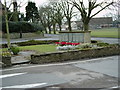
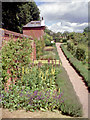
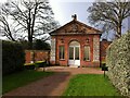
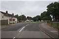
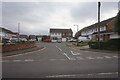
B36 9DX forms part of Castle Bromwich, a civil parish in Warwickshire located approximately five miles from Birmingham city centre. This specific postcode covers a small residential cluster defined by a distinct suburban character within the wider West Midlands conurbation. The area has evolved from a rural community dependent on farming for a thousand years into a modern suburb, yet it retains significant historical identity. Evidence of habitation dates back nearly 5,000 years, anchored by a raised piece of land close to a natural ford across the River Tame. A notable landmark is the village green, which has historically served as a focal point for local gatherings. The settlement's origins trace back to a timber castle built on a hill after the Norman Conquest. Today, a Scheduled Ancient Monument marks the site of this castle mound. Nearby, Castle Bromwich Hall and Gardens offer a rare example of a 17th-century Jacobean country house with an original garden setting covering ten acres. The prominent St Mary & St Margaret's Church has served as the spiritual and social heart of the community for almost 900 years. Living in B36 9DX means you are within reach of these historic landmarks while enjoying the practical convenience of a well-connected suburb today. The environment combines quiet residential streets with access to major transport routes and local amenities.
- Area Type
- Postcode
- Area Size
- Not available
- Population
- 1427
- Population Density
- 2334 people/km²
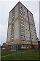
The property market for B36 9DX is defined by traditional housing stock and high stability. Eighty-eight per cent of homes in this postcode are owner-occupied, creating a stable market with little turnover due to investment speculation. This high ownership rate signals that the area is sought after by residents who plan to live there long-term. Accommodation types in this vicinity are predominantly houses, offering the privacy and space typical of suburban living in the West Midlands. You are unlikely to find a significant concentration of flats or purpose-built rental blocks compared to newer city fringe developments. The housing landscape in B36 9DX reflects the transformation of the suburb from a rural hamlet. Properties here likely maintain individual histories and character, often situated on larger plots given the house-based accommodation type. With 88% home ownership, buying a property in this area often means joining an existing community of owners rather than entering a transient rental market. The market dynamics suggest a preference for established homes, potentially including period properties influenced by the local Jacobean heritage and agricultural history. Buyers looking for this type of stock should expect competition from owner-occupiers rather than landlords.
House Prices in B36 9DX
No properties found in this postcode.
Energy Efficiency in B36 9DX
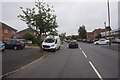
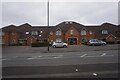
Daily life in B36 9DX benefits from a strong leisure network within a short distance. Residents have access to five notable retail outlets, including Spar, Heron Shard, and Iceland Castle. These shops are located within practical reach, providing convenience for groceries and daily essentials without requiring longer journeys into Birmingham. For those preferring independent trading, these local businesses serve the specific needs of the 1,427 residents in the postcode. Cultural and transport amenities further enrich the experience of living here. Five rail stations including Lea Hall and Stechford offer convenient commutes. Metro connections are also strong, with proximity to Birmingham International Airport and Birmingham Intl Railway Station. You can catch services to Goole Street or other nearby hubs from these connected nodes. The area balances quiet suburban living with the accessibility of major travel arteries. The Crown Galleries could serve as a local shopping destination depending on business hours. This blend allows you to enjoy a village atmosphere while remaining connected to the wider West Midlands network.
Amenities
Schools
Families living in B36 9DX have access to well-rated educational institutions nearby. St Mary and St Margaret's Church of England Aided Primary School is located at a short distance from the postcode boundary. This school holds a 'good' Ofsted rating, indicating high standards in education and governance. As a primary institution, it caters to younger children, often serving as the first educational step for residents. The enclosed nature of the local area means most children can walk to school or be easily picked up from local clusters. For secondary education or further schooling, residents typically access broader options within the wider Castle Bromwich and Birmingham vicinity. The presence of a primary school with a good rating suggests that the area attracts families prioritising early education quality. Living in B36 9DX provides direct access to this specific faith-based foundation school. The educational provision supports the demographic profile of adults aged 30 to 64, offering relevant options for the core family unit. Parents can rely on the maintained inspection rating when making decisions about schools near B36 9DX.
| Rank | School | Type | Entry gender | Ages |
|---|
Explore more schools in this area
Go to Schools tabDemographics
The community in B36 9DX consists of 1,427 residents, creating a tight-knit neighbourhood feel. The median age is 47 years, with adults aged between 30 and 64 forming the most common age range in the area. This demographic profile suggests a settlement predominantly occupied by families and established households rather than students or young professionals. House ownership is exceptionally high, with 88% of residents owning their homes outright or with a mortgage. This statistic indicates that the local estates are primarily composed of owner-occupied properties rather than private or social rentals. The predominant ethnic group in this postcode is White, reflecting the area's established status since its transformation in the 20th century. Homes in B36 9DX are primarilyhouses, offering more space and private grounds compared to urban flats. The local population benefits from a low deprivation profile, contributing to a stable and secure environment. Nearly nine out of ten residents are owner-occupied, reinforcing the area's character as a family-friendly location. The absence of significant deprivation markers supports the high quality of life observed in this part of Castle Bromwich.
Household Size
Accommodation Type
Tenure
Ethnic Group
Religion
Household Composition
Age
Household Deprivation
NS-SEC
Explore more demographic insights in this area
Go to Demographics tabPlanning
Planning Constraints
- Flood RiskPremium
- Ramsar Wetland SitesPremium
- Area of Outstanding Natural BeautyPremium
- Protected Nature ReservePremium
- Protected WoodlandPremium