Area Overview for B36 8TW
Photos of B36 8TW


Area Information
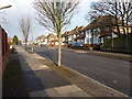
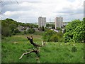
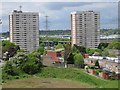
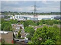
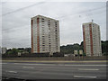
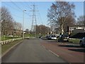
B36 8TW is a small residential postcode area in east Birmingham, England, encompassing parts of Hodge Hill and Bromford. With a population of 2,211, it sits approximately 7 kilometres east of Birmingham city centre, bordered by the River Tame and River Cole. The area blends post-war housing estates like the Bromford Estate and The Firs with pockets of open space, including Hodge Hill Common and the Cole Valley Nature Conservation Area. Historically, it was shaped by industrial activity, with Bromford Mill’s legacy still evident in the local economy. Today, the area is defined by its suburban character, with residential clusters separated from industrial zones by the M6 motorway. While the community is diverse, with a strong Asian presence and a median age of 47, it retains a distinct identity shaped by its history and geography. Living here means navigating a mix of modern housing, natural amenities, and proximity to Birmingham’s broader infrastructure, though the area’s charm lies in its quieter, less densely populated feel compared to the city centre.
- Area Type
- Postcode
- Area Size
- Not available
- Population
- 2211
- Population Density
- 6424 people/km²
B36 8TW is a small area with a housing stock predominantly composed of houses, reflecting its suburban character. With 68% home ownership, the area is more likely to be owner-occupied than rental-focused, though the limited size of the postcode suggests a constrained property market. The presence of post-war housing estates like the Bromford Estate and The Firs indicates a mix of older properties, some of which may require renovation. Buyers should consider the area’s proximity to industrial zones and the M6 motorway, which may affect property values and desirability. The lack of high-density housing or commercial development means the market is unlikely to cater to large-scale investment or rental demand. For buyers seeking a quiet, family-oriented environment, the area’s housing stock offers a blend of traditional homes and established neighbourhoods, though the limited number of properties may mean competition for available listings.
House Prices in B36 8TW
No properties found in this postcode.
Energy Efficiency in B36 8TW
Residents of B36 8TW have access to a range of nearby amenities that support daily life. The retail sector includes stores such as Tesco Hodge, Iceland Washwood, and Aldi Hodge, offering essential shopping options within walking or short driving distance. Public transport links are well-established, with rail stations like Stechford, Gravelly Hill, and Adderley Park providing connections to Birmingham’s broader network. Metro stops at Bull Street, St Chads, and Corporation Street add to the area’s accessibility. Open spaces like Hodge Hill Common and the Cole Valley Nature Conservation Area provide recreational opportunities, while the historical Bromford Gate industrial park and Fort Shopping Park hint at a blend of heritage and modern retail. The area’s mix of practical amenities and natural spaces creates a balanced lifestyle, though the separation of residential and industrial zones may influence the overall character of daily living.
Amenities
Schools
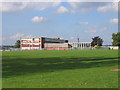
The nearest school to B36 8TW is the Heart of Birmingham Vocational College, a special school catering to students with specific educational needs. While no other schools are listed in the data, this institution suggests that families in the area may need to travel beyond the immediate postcode for primary or secondary education. The vocational focus of the school aligns with the area’s industrial heritage and local employment opportunities, though it does not provide a full range of educational stages. Parents seeking a broader selection of schools may need to consider nearby districts or commuting to Birmingham’s city centre. The absence of additional schools in the data highlights a potential gap in local provision, though the existing institution serves a niche but important role in the community.
| Rank | School | Type | Entry gender | Ages |
|---|
Explore more schools in this area
Go to Schools tabDemographics
The population of B36 8TW is 2,211, with a median age of 47, reflecting a community skewed towards adults aged 30–64. Home ownership rates are 68%, indicating a stable, largely owner-occupied demographic. The predominant accommodation type is houses, which aligns with the area’s suburban layout. The predominant ethnic group is Asian_total, contributing to a diverse demographic profile. This contrasts with Birmingham’s broader population, where B36 8TW has a higher proportion of BAME residents and a younger age profile. The community’s diversity is evident in its social mix, though specific deprivation data is not provided. The presence of post-war housing estates suggests a mix of older and newer properties, with initiatives like Firs and Bromford Neighbours Together aiming to enhance local cohesion. The age profile, centred on middle-aged adults, may influence local amenities and services, such as schools and retail, which cater to families and older residents.
Household Size
Accommodation Type
Tenure
Ethnic Group
Religion
Household Composition
Age
Household Deprivation
NS-SEC
Explore more demographic insights in this area
Go to Demographics tabPlanning
Planning Constraints
- Flood RiskPremium
- Ramsar Wetland SitesPremium
- Area of Outstanding Natural BeautyPremium
- Protected Nature ReservePremium
- Protected WoodlandPremium