Area Overview for B36 8JA
Photos of B36 8JA


Area Information
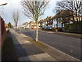
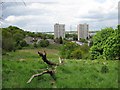
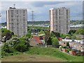
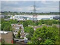
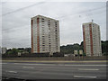
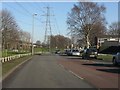
B36 8JA lies in the Bromford & Hodge Hill area of east Birmingham, a suburban ward characterised by a blend of residential neighbourhoods and industrial zones. With a population of 1,987, this small postcode area is part of a larger ward with a total population of 22,382, reflecting its role as a distinct yet interconnected suburb. The area’s proximity to the M6 motorway and the River Tame shapes its geography, with residential zones like Bromford Estate and The Firs sitting east of the motorway. Historically, Hodge Hill was a manor recorded in 1569, while Bromford’s industrial legacy includes former steel mills and post-war housing developments. Today, the area balances older estates with modern infrastructure, offering a mix of community and convenience. Residents benefit from nearby rail links, retail outlets, and open spaces like Hodge Hill Common, though the divide between industrial and residential areas remains a defining feature.
- Area Type
- Postcode
- Area Size
- Not available
- Population
- 1987
- Population Density
- 7811 people/km²
The property market in B36 8JA is predominantly owner-occupied, with 74% of homes owned by residents rather than rented. This suggests a stable housing stock, though the area’s small size means the market is limited to a few hundred properties. The accommodation type is primarily houses, which contrasts with the higher density of flats in other parts of Birmingham. This housing mix may appeal to families seeking more space, though the post-war estates like Bromford Estate and The Firs indicate a range of property ages and conditions. Buyers should consider the area’s proximity to the M6 and industrial zones, which may influence property values and desirability. For those prioritising owner-occupation, B36 8JA offers a chance to invest in a residential cluster with established infrastructure, though the immediate surroundings may require exploration for larger options.
House Prices in B36 8JA
No properties found in this postcode.
Energy Efficiency in B36 8JA
Living in B36 8JA offers access to a range of amenities within practical reach. Retail options include Spar, Tesco Hodge, and Aldi Hodge, providing everyday shopping convenience. The area is served by five railway stations and three metro stops, including Stechford Railway Station and Bull Street, facilitating easy travel to Birmingham’s commercial and cultural hubs. Open spaces like Hodge Hill Common and Cole Valley Nature Conservation Area offer recreational opportunities, while historical sites such as Bromford Mill and Fort Dunlop add to the area’s character. The mix of post-war housing estates and industrial parks creates a distinct suburban feel, with community initiatives aiming to enhance local cohesion. Residents can enjoy a blend of practicality and greenery, though the proximity to industrial zones may influence the overall atmosphere. The presence of nearby retail and transport links ensures a lifestyle that balances convenience with suburban tranquillity.
Amenities
Schools
| Rank | School | Type | Entry gender | Ages |
|---|
Explore more schools in this area
Go to Schools tabDemographics
B36 8JA has a median age of 22, but the most common age range is 30–64 years, suggesting a mix of younger residents and established adults. Home ownership stands at 74%, with houses being the predominant accommodation type, indicating a stable, family-oriented community. The area’s population includes a significant proportion of the Asian_total ethnic group, contributing to a diverse demographic profile. This diversity is reflected in the ward’s broader context, where the BAME population share is notably higher than Birmingham’s average. The younger median age contrasts with the higher proportion of middle-aged residents, potentially shaping a dynamic but settled environment. While deprivation data is not explicitly provided, the high home ownership rate and presence of post-war housing estates suggest a mix of economic backgrounds. The area’s character is defined by its suburban layout, with initiatives like Firs and Bromford Neighbours Together aiming to foster community cohesion.
Household Size
Accommodation Type
Tenure
Ethnic Group
Religion
Household Composition
Age
Household Deprivation
NS-SEC
Explore more demographic insights in this area
Go to Demographics tabPlanning
Planning Constraints
- Flood RiskPremium
- Ramsar Wetland SitesPremium
- Area of Outstanding Natural BeautyPremium
- Protected Nature ReservePremium
- Protected WoodlandPremium