Area Overview for B35 7EJ
Photos of B35 7EJ
Area Information
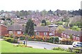
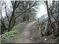
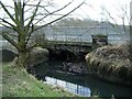
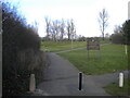
Living in B35 7EJ means residing within Castle Vale, a distinctive housing estate in the eastern part of Birmingham. This specific postcode cluster covers an area of 3051 m² and is home to 1575 people. The estate originally occupied the site of the Castle Bromwich Aerodrome, which served as a major airfield from 1914 to 1960 before the development of the current residential estate began in 1964. Once infamous as a large-scale failed postwar overspill estate, the neighbourhood has undergone significant regeneration since the Castle Vale Housing Action Trust was established in 1993. You will find a community where high-rise blocks were once the dominant feature, but substantial improvements have transformed daily life. A 15-kilometre network of footpaths now runs around the perimeter and through the estate, created as part of Project Wagtail to encourage outdoor activity. The area retains a sense of history through landmarks like The Sanctuary, which opened in 2000 as a community events venue on Tangmere Drive. A primary care centre also developed around this drive, completed in 2004. This location offers a blend of residential calm and historical significance, situated away from the city centre yet close enough to benefit from Birmingham's wider infrastructure.
- Area Type
- Postcode
- Area Size
- 3051 m²
- Population
- 1575
- Population Density
- 5959 people/km²
The property market in B35 7EJ is dominated by rental properties rather than owner-occupied homes. With a home ownership rate of just 25 per cent, the local housing stock skews heavily towards the rental sector. The primary accommodation type found in this specific postcode area are houses. This distinction is notable for a large postwar estate, where many residents might expect to find flats or maisonettes. The low ownership percentage suggests a active letting market or households that prefer renting over buying. Buyers looking at this area should focus heavily on the private rented sector, particularly if they are property investors or searching for houses to let. The historical context of the estate, built to accommodate nearly 11,000 residents at its peak with 4,800 homes, leaves a legacy of substantial housing volumes. However, the current regeneration and the 15-kilometre footpath network have altered the housing landscape. When viewing homes in B35 7EJ, you will encounter a mix of original estate properties and regenerated units. The physical layout remains that of a housing estate, but the social dynamics have shifted towards a more mixed tenure model.
House Prices in B35 7EJ
Showing 16 properties
| Address | Type | Beds | Baths | Last Sale Price | Last Sale Date | |
|---|---|---|---|---|---|---|
| 39 Cadbury Drive, Birmingham, B35 7EJ | Flat | - | - | £86,500 | Nov 2019 | |
| 31 Cadbury Drive, Birmingham, B35 7EJ | Maisonette | - | - | £35,000 | Nov 2000 | |
| 29 Cadbury Drive, Birmingham, B35 7EJ | Flat | - | - | - | - | |
| 25 Cadbury Drive, Birmingham, B35 7EJ | Maisonette | - | - | - | - | |
| 21 Cadbury Drive, Birmingham, B35 7EJ | Flat | - | - | - | - | |
| 23 Cadbury Drive, Birmingham, B35 7EJ | Maisonette | - | - | - | - | |
| 9 Cadbury Drive, Birmingham, B35 7EJ | Flat | - | - | - | - | |
| 19 Cadbury Drive, Birmingham, B35 7EJ | Maisonette | - | - | - | - | |
| 27 Cadbury Drive, Birmingham, B35 7EJ | Flat | - | - | - | - | |
| 17 Cadbury Drive, Birmingham, B35 7EJ | Flat | - | - | - | - |
Energy Efficiency in B35 7EJ
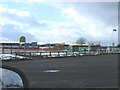
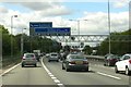
Residents of B35 7EJ enjoy a range of convenient amenities within practical reach of their homes. Five retail outlets are available nearby, including Sainsburys Castle, Farmfoods Erdington, and Spar, ensuring everyday shopping essentials are accessible. For those preferring rail travel, five stations serve the surrounding area, with Water Orton, Stechford, and Erdington Railway Stations being the most direct links. Metro connectivity is also robust, with access to Birmingham International Airport, Bull Street, and St Chads stations. This transport network supports both daily commuting and leisure travel. The estate itself features historical amenities that remain in use, such as The Sanctuary on Tangmere Drive, which opened in 2000 as a community events venue. A 15-kilometre network of footpaths encircles the estate, created during Project Wagtail, offering ample space for walking and cycling. A primary care centre, completed in 2004 at a cost of £4 million, serves as a focal point for health services around Tangmere Drive. This blend of modern retail, historical community spaces, and extensive green corridors defines the lifestyle in this area.
Amenities
Schools
Families living in B35 7EJ have access to two key primary institutions immediately on their doorstep. Chivenor Junior and Infant School serves as a local educational facility for young children. Nearby, Chivenor Primary School holds a 'good' Ofsted rating, providing assurance on educational standards for prospective parents. Both schools are situated within easy reach of the postcode, making daily pick-ups convenient. The presence of these two primary options means parents do not need to travel far to find education for their children. The mix of school types, including junior and infant provisions alongside a primary school with a positive rating, supports various age groups within the family unit. For those considering homes near B35 7EJ, the proximity to Chivenor Primary School is a significant practical advantage. The estate originally included five schools, indicating a long-standing commitment to local education within Castle Vale. While this data only lists primary institutions, the historical presence of such facilities underscores the area's focus on family infrastructure. Choosing homes in this cluster connects you directly to these established educational settings without requiring long commutes.
| Rank | School | Type | Entry gender | Ages |
|---|
Explore more schools in this area
Go to Schools tabDemographics
The community in B35 7EJ reflects an established, mature neighbourhood with a median age of 47 years. Most residents are adults aged between 30 and 64 years, suggesting families and individuals who have settled in the area for some time. Housing in this postcode cluster consists primarily of houses, defining the accommodation type available to buyers. Home ownership stands at 25 per cent, indicating that three-quarters of the 1575 residents rent their homes. The predominant ethnic group is White, aligning with the historical development of the area. With a population density of 516144 people per square kilometre, the estate feels densely populated within its compact footprint. This demographic profile points to a stable community where long-term residents form the majority. The concentration of older adults suggests a need for amenities that cater to established households rather than transient populations. Rental stock forms the majority of the accommodation, which impacts the nature of tenancy agreements and community cohesion compared to areas with higher ownership rates.
Household Size
Accommodation Type
Tenure
Ethnic Group
Religion
Household Composition
Age
Household Deprivation
NS-SEC
Explore more demographic insights in this area
Go to Demographics tabPlanning
Planning Constraints
- Flood RiskPremium
- Ramsar Wetland SitesPremium
- Area of Outstanding Natural BeautyPremium
- Protected Nature ReservePremium
- Protected WoodlandPremium