Area Overview for B34 6DP
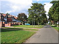
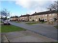
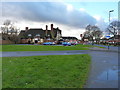
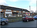
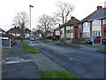
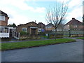
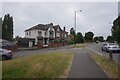
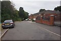
Photos of B34 6DP

Area Information
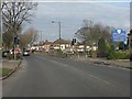
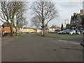
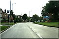
Living in B34 6DP means inhabiting a small residential cluster in east Birmingham, part of the Bromford & Hodge Hill ward. This area blends post-war housing estates like the Bromford Estate with pockets of open space, including Hodge Hill Common and the Cole Valley Nature Conservation Area. The population of 1,792 reflects a tight-knit community, though the ward as a whole has a larger population of 22,382. Residents live near the River Tame and M6 motorway, which separates industrial zones to the north from residential areas to the east. The area’s history includes 19th-century steel production and 20th-century housing developments, creating a mix of older homes and modern infrastructure. Daily life here balances proximity to Birmingham’s city centre (7km away) with the relative quiet of suburban living. The presence of initiatives like Firs and Bromford Neighbours Together suggests a community focused on local improvement. For buyers, this area offers a blend of practicality and historical character, though its industrial and residential separation may influence lifestyle choices.
- Area Type
- Postcode
- Area Size
- Not available
- Population
- 1792
- Population Density
- 5866 people/km²
The property market in B34 6DP is dominated by owner-occupied homes, with 77% of properties owned by residents rather than rented. This high ownership rate suggests a community with long-term residents and a stable housing market. The predominant accommodation type is houses, which contrasts with areas where flats or apartments dominate. This housing stock likely includes post-war estates like the Bromford Estate, which were developed in the 1960s. For buyers, this means a focus on semi-detached or detached homes, which may offer more space and privacy than apartment living. However, the small size of the postcode area (1,792 residents) implies limited housing stock, potentially restricting availability. The mix of older homes and newer developments may appeal to those seeking value or historical character. Given the high home ownership, the area may be less attractive to renters, though the exact rental market dynamics are not specified.
House Prices in B34 6DP
No properties found in this postcode.
Energy Efficiency in B34 6DP
Residents of B34 6DP have access to a range of amenities within practical reach. Nearby retail options include Spar, Heron Shard, and Aldi Hodge, offering everyday shopping needs. The area’s proximity to railway stations like Stechford and Lea Hall provides easy access to Birmingham’s transport network, while Birmingham International Airport is within reach for travel. Open spaces such as Hodge Hill Common and the Cole Valley Nature Conservation Area offer recreational opportunities, contrasting with the industrial zones to the north. The area’s character is defined by its mix of residential tranquility and historical sites like Bromford Mill. While the data does not specify dining or leisure venues, the presence of retail and transport hubs suggests a functional lifestyle. The blend of green spaces and practical amenities creates a balance between suburban convenience and natural surroundings, though the lack of detailed information on leisure options leaves some aspects of daily life unexplored.
Amenities
Schools
Residents of B34 6DP have access to two primary schools: Heathlands Junior and Infant School (NC) and Heathlands Primary Academy. Both are primary institutions, catering to younger children, though no secondary schools are listed in the data. Heathlands Primary Academy has an Ofsted rating of ‘good’, indicating a satisfactory standard of education. The presence of two primary schools suggests that families with young children have nearby options, though the absence of secondary schools may require commuting to nearby areas. The ‘good’ rating at Heathlands Primary Academy implies a school that meets acceptable standards in teaching, safety, and outcomes. However, without data on secondary education or additional schools, the full range of educational opportunities remains unclear. For families prioritising primary education, this area offers two options, but further research would be needed for secondary schooling.
| Rank | School | Type | Entry gender | Ages |
|---|
Explore more schools in this area
Go to Schools tabDemographics
The community in B34 6DP has a median age of 47, with the most common age range being adults aged 30–64. This suggests a population skewed towards middle-aged individuals, likely including families and professionals. Home ownership is high at 77%, indicating a stable, long-term resident base. The predominant accommodation type is houses, which aligns with the area’s suburban character. The dominant ethnic group is the Asian population, reflecting a diverse demographic profile. This diversity is notable compared to Birmingham’s broader population, which has a lower proportion of BAME residents. The area’s age profile and ownership rates suggest a community with established roots, though the absence of specific deprivation data means quality of life factors like income or access to services remain unquantified. The mix of age groups and ethnic backgrounds contributes to a varied social fabric, though the lack of detailed socioeconomic data limits deeper analysis.
Household Size
Accommodation Type
Tenure
Ethnic Group
Religion
Household Composition
Age
Household Deprivation
NS-SEC
Explore more demographic insights in this area
Go to Demographics tabPlanning
Planning Constraints
- Flood RiskPremium
- Ramsar Wetland SitesPremium
- Area of Outstanding Natural BeautyPremium
- Protected Nature ReservePremium
- Protected WoodlandPremium