Area Overview for B33 9RY
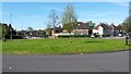
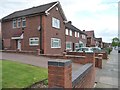
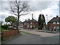
Photos of B33 9RY


Area Information
B33 9RY is a small residential postcode area nestled in the north of Birmingham, part of the Glebe Farm & Tile Cross electoral ward. With a population of 1,632, it is a compact community characterised by its historical roots in the Forest of Arden, where woodland clearings once defined the landscape. The area’s boundaries are marked by the Birmingham Loop railway line to the south and the River Cole to the north, shaping its quiet, residential charm. Daily life here is defined by proximity to local amenities, including rail stations, retail outlets, and the nearby Birmingham International Airport. The community is predominantly composed of adults aged 30–64, reflecting a mature demographic. While the area lacks large-scale commercial hubs, its small size fosters a sense of closeness, with homes primarily in private ownership. For those seeking a low-key, historically grounded place to live, B33 9RY offers a blend of practicality and heritage, though its limited size means residents must look beyond the postcode for broader opportunities.
- Area Type
- Postcode
- Area Size
- Not available
- Population
- 1632
- Population Density
- 6265 people/km²
B33 9RY’s property market is defined by its small size and the predominance of houses. With a home ownership rate of 42%, the area is not heavily dominated by owner-occupied properties, suggesting a significant rental market. This dynamic may mean that buyers face competition for the limited housing stock, particularly as the area’s compact nature restricts expansion. The focus on houses rather than flats or apartments indicates a preference for traditional, perhaps larger properties, which could appeal to families or those seeking more space. However, the small scale of the postcode means that the immediate surroundings may hold more options. For buyers, this could mean a need to look beyond B33 9RY itself for a broader selection, though the area’s proximity to Birmingham’s infrastructure may offset its limited local stock.
House Prices in B33 9RY
No properties found in this postcode.
Energy Efficiency in B33 9RY
The lifestyle in B33 9RY is shaped by its proximity to practical amenities, though the area’s small size means residents must venture slightly beyond the postcode for more expansive options. Within reach are five retail outlets, including Asda Sheldon and Lidl Stetchford, offering everyday shopping needs. The rail network, with five stations such as Lea Hall and Stechford, provides access to Birmingham’s broader transport system, including connections to the airport and central city hubs. While there is no mention of parks or leisure facilities in the data, the presence of multiple rail and metro points suggests opportunities for travel to larger recreational areas. The character of daily life here is defined by convenience for local errands and commuting, though the area lacks the density of high-street shopping or extensive green spaces. Residents may need to look beyond B33 9RY for more varied leisure options, but the existing amenities support a straightforward, functional lifestyle.
Amenities
Schools
Residents of B33 9RY have access to a range of educational institutions, including Ridpool Primary and Nursery School, which serves younger children, and Lea Forest Primary Academy, a primary school with an outstanding Ofsted rating. This latter school’s high rating is a significant draw for families prioritising quality education. The area also includes Lea Hall Academy, a special school catering to students with specific needs. The mix of primary and special schools reflects a commitment to supporting diverse educational requirements, from early years through to specialist provision. While there are no secondary schools listed, the presence of multiple primary options ensures that families have choices for younger children. The proximity of these schools to homes in B33 9RY makes the area appealing for those seeking a well-served educational environment.
| Rank | School | Type | Entry gender | Ages |
|---|
Explore more schools in this area
Go to Schools tabDemographics
The population of B33 9RY has a median age of 47, with the majority of residents falling within the 30–64 age range. This suggests a community of established professionals and families, rather than a transient or youthful demographic. Home ownership in the area stands at 42%, indicating that nearly half of residents rent their homes, which may reflect the area’s smaller housing stock and potential rental market dynamics. The predominant accommodation type is houses, which aligns with the residential character of the postcode. The predominant ethnic group is White, though specific data on diversity or deprivation is not provided. The age profile implies a stable, mature community, potentially with strong local ties and a focus on long-term residency. However, the lower home ownership rate may suggest a reliance on rental properties, which could influence the area’s housing affordability and market competition.
Household Size
Accommodation Type
Tenure
Ethnic Group
Religion
Household Composition
Age
Household Deprivation
NS-SEC
Explore more demographic insights in this area
Go to Demographics tabPlanning
Planning Constraints
- Flood RiskPremium
- Ramsar Wetland SitesPremium
- Area of Outstanding Natural BeautyPremium
- Protected Nature ReservePremium
- Protected WoodlandPremium