Area Overview for B33 9EA
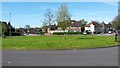
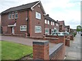
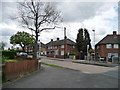
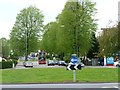
Photos of B33 9EA


Area Information
Living in B33 9EA means being part of a small, tightly knit residential cluster in north Birmingham, bounded by the River Cole to the north and the Birmingham Loop railway line to the south. The area, known as Glebe Farm & Tile Cross, has roots in the Forest of Arden, with historical traces like the Riddings road hinting at its wooded past. With a population of 1,617, it’s a compact community where daily life is shaped by proximity to transport links and local amenities. The area’s character blends historical legacy with modern infrastructure, from 1930s housing developments to contemporary retail and rail access. Residents benefit from five nearby railway stations, including Lea Hall and Stechford, and are within reach of Birmingham International Airport. While the area lacks natural beauty designations, its practical connectivity and modest size make it a pragmatic choice for those prioritising ease of access over scenic landscapes. The median age of 47 suggests a mature population, with a focus on stability and established living, reflected in the 53% home ownership rate. For buyers, B33 9EA offers a snapshot of suburban Birmingham, where history meets convenience.
- Area Type
- Postcode
- Area Size
- Not available
- Population
- 1617
- Population Density
- 7819 people/km²
The property market in B33 9EA is characterised by a 53% home ownership rate, indicating that nearly half of residents live in owner-occupied homes, while the remaining 47% are likely renters. The accommodation type is predominantly houses, which is notable given the area’s small size. This suggests a focus on single-family dwellings rather than flats or apartments, aligning with the historical development of the Glebe Farm Council Estate built in the 1930s. For buyers, this means a limited but distinct housing stock, with properties likely to be larger and more traditional in style. The area’s compact nature means that the immediate surroundings may offer similar housing types, though the lack of specific data on property sizes or price ranges limits deeper analysis. The mix of ownership and rental units could indicate a balance between long-term residents and transient occupants, though the high proportion of houses may appeal to those seeking space and privacy. Buyers should consider the area’s small footprint when exploring nearby options.
House Prices in B33 9EA
No properties found in this postcode.
Energy Efficiency in B33 9EA
Residents of B33 9EA have access to a range of amenities within practical reach. Retail options include Asda Sheldon, Iceland Stechford, and Co-op Shard, offering everyday shopping needs. The area’s proximity to Birmingham International Airport and railway stations like Bull Street and Birmingham Intl Railway Station enhances its appeal for those reliant on travel. While the data does not mention parks or leisure facilities, the historical context of the Forest of Arden suggests potential green spaces nearby. The presence of five metro points, including the airport, adds to the area’s convenience, enabling quick access to Birmingham’s urban core. Daily life is shaped by these amenities, with shops and transport hubs within walking or short driving distance. The character of the area is defined by its blend of residential tranquillity and practical connectivity, making it suitable for those who value accessibility without sacrificing a sense of community.
Amenities
Schools
| Rank | School | Type | Entry gender | Ages |
|---|
Explore more schools in this area
Go to Schools tabDemographics
The community in B33 9EA is predominantly composed of adults aged 30–64, with a median age of 47. This suggests a population largely in their prime working years, likely balancing career and family life. Home ownership sits at 53%, indicating a mix of owner-occupied properties and rental units, though the data does not specify the proportion of renters. The accommodation type is primarily houses, which aligns with the area’s residential cluster identity. The predominant ethnic group is White, though no further breakdown of diversity is provided. The absence of specific data on deprivation means the quality of life cannot be assessed in that context, but the age profile implies a stable, experienced demographic. With no mention of young families or elderly residents, the community appears focused on middle-aged individuals and couples. This profile may influence local amenities, with services tailored to adult needs rather than childcare or retirement facilities. The area’s small size and historical housing stock suggest a consistent, low-turnover environment.
Household Size
Accommodation Type
Tenure
Ethnic Group
Religion
Household Composition
Age
Household Deprivation
NS-SEC
Explore more demographic insights in this area
Go to Demographics tabPlanning
Planning Constraints
- Flood RiskPremium
- Ramsar Wetland SitesPremium
- Area of Outstanding Natural BeautyPremium
- Protected Nature ReservePremium
- Protected WoodlandPremium