Area Overview for B33 0NY
Photos of B33 0NY
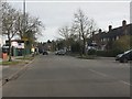
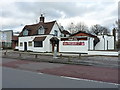
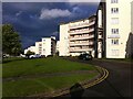
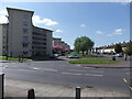
22 photos from this area
Area Information
Key information about the B33 0NY including its size, population, and administrative classification.
- Area Type
- Postcode
- Area Size
- 1.2 hectares
- Population
- 1507
- Population Density
- 3046 people/km²
House Prices in B33 0NY
14
Properties
£114,057
Average Sold Price
£52,500
Lowest Price
£180,000
Highest Price
Showing 14 properties
| Address | Type | Beds | Baths | Last Sale Price | Last Sale Date | |
|---|---|---|---|---|---|---|
| 101 Pitfield Road, Birmingham, B33 0NY | house | - | - | £180,000 | Mar 2023 | |
| 103 Pitfield Road, Birmingham, B33 0NY | house | - | - | £129,950 | Aug 2018 | |
| 93 Pitfield Road, Birmingham, B33 0NY | house | - | - | £121,000 | Jan 2018 | |
| 107 Pitfield Road, Birmingham, B33 0NY | house | - | - | £105,000 | Nov 2012 | |
| 81 Pitfield Road, Birmingham, B33 0NY | Terraced | 3 | 1 | £109,950 | Nov 2009 | |
| 95 Pitfield Road, Birmingham, B33 0NY | Terraced | 2 | - | £100,000 | May 2007 | |
| 91 Pitfield Road, Birmingham, B33 0NY | Terraced | - | - | £52,500 | Nov 2001 | |
| 85 Pitfield Road, Birmingham, B33 0NY | Terraced | 3 | 1 | - | - | |
| 99 Pitfield Road, Birmingham, B33 0NY | house | - | - | - | - | |
| 87 Pitfield Road, Birmingham, B33 0NY | house | - | - | - | - |
Page 1 of 2
Energy Efficiency in B33 0NY
Amenities
Schools
| Rank | School | Type | Entry gender | Ages |
|---|
Explore more schools in this area
Go to Schools tabDemographics
Household Size
One person
most common
Accommodation Type
Houses
most common
Tenure
52
majority
Ethnic Group
White
most common
Religion
N/A
most common
Household Composition
N/A
most common
Age
47
median
Adults (30-64 years)
most common
Household Deprivation
N/A
with no deprivation
NS-SEC
16
in Lower managerial occupations
Explore more demographic insights in this area
Go to Demographics tabPlanning
Planning Constraints
- Flood RiskPremium
- Ramsar Wetland SitesPremium
- Area of Outstanding Natural BeautyPremium
- Protected Nature ReservePremium
- Protected WoodlandPremium