Area Overview for B30 2BD
Photos of B30 2BD


Area Information
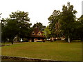
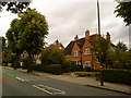
B30 2BD is a small, tightly knit residential postcode in southwest Birmingham, encompassing parts of the historic Bournville and Cotteridge areas. With a population of 1,712, it retains a suburban, low-density character shaped by its origins as a 19th-century model village founded by the Quaker Cadbury family. The area blends planned garden village design with older rural settlement features, including conservation status and heritage sites. Residents benefit from proximity to Birmingham’s central amenities while retaining a distinct, quieter atmosphere. The Cadbury chocolate factory, established in 1879, remains a key local landmark, alongside Bournville Park and relocated historic buildings like Selly Manor. Daily life here is defined by tree-lined streets, spacious gardens, and a community ethos rooted in Quaker principles, including the historic dry town status of the Bournville estate. The area’s charm lies in its mix of heritage, green spaces, and practical connectivity to Birmingham’s transport networks.
- Area Type
- Postcode
- Area Size
- Not available
- Population
- 1712
- Population Density
- 4265 people/km²
B30 2BD is primarily a residential area with a strong emphasis on houses, reflecting its suburban, low-density planning. With 49% of homes owner-occupied, the market is not dominated by rentals but includes a mix of private and possibly leasehold properties. The conservation status of Bournville, overseen by the Bournville Village Trust, means property development is tightly controlled, preserving historic architecture and garden village design. This restricts modern high-density housing, ensuring the area retains its character. For buyers, this means limited new builds but a focus on established, well-maintained homes with gardens. The small postcode area suggests properties are concentrated in specific pockets, requiring buyers to consider proximity to amenities like the Cadbury factory or transport links. The historical significance of the area may also influence property values, with heritage features adding to their appeal.
House Prices in B30 2BD
No properties found in this postcode.
Energy Efficiency in B30 2BD
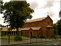
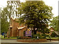
Living in B30 2BD offers access to a range of amenities within practical reach. Retail options include Morrisons Daily, Farmfoods Stirchley, and other local stores, ensuring daily essentials are easily obtainable. Rail stations like Bournville and Selly Oak provide quick access to Birmingham’s transport network, while the nearby metro stops at Edgbaston Village and Centenary Square link to the city’s cultural and commercial centres. Parks such as Bournville Park and Cotteridge Park offer green spaces for recreation, with historical sites like the Cadbury chocolate factory and relocated Selly Manor adding to the area’s unique charm. The presence of the Worcester and Birmingham Canal also provides leisure opportunities. The combination of retail, transport, and green spaces creates a convenient, balanced lifestyle for residents.
Amenities
Schools
| Rank | School | Type | Entry gender | Ages |
|---|
Explore more schools in this area
Go to Schools tabDemographics
The population of B30 2BD has a median age of 47, with the most common age group being adults aged 30–64. This suggests a mature, stable community with a focus on family living. Home ownership rates stand at 49%, indicating a moderate balance between owner-occupied properties and rental stock. The area is predominantly composed of houses, reflecting its low-density, suburban layout. The predominant ethnic group is White, though no specific diversity statistics are provided. The age profile and housing type suggest a mix of long-term residents and families seeking established, quieter neighbourhoods. The absence of detailed deprivation data means the area’s quality of life remains unquantified, but the demographic stability and housing stock imply a cohesive, settled community.
Household Size
Accommodation Type
Tenure
Ethnic Group
Religion
Household Composition
Age
Household Deprivation
NS-SEC
Explore more demographic insights in this area
Go to Demographics tabPlanning
Planning Constraints
- Flood RiskPremium
- Ramsar Wetland SitesPremium
- Area of Outstanding Natural BeautyPremium
- Protected Nature ReservePremium
- Protected WoodlandPremium