Area Overview for B29 7EJ
Photos of B29 7EJ

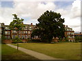
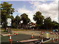
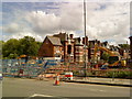
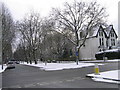
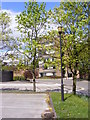


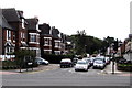
100 photos from this area
Area Information
Key information about the B29 7EJ including its size, population, and administrative classification.
- Area Type
- Postcode
- Area Size
- 3.1 hectares
- Population
- 1766
- Population Density
- 4910 people/km²
House Prices in B29 7EJ
24
Properties
£540,850
Average Sold Price
£351,500
Lowest Price
£790,000
Highest Price
Showing 24 properties
| Address | Type | Beds | Baths | Last Sale Price | Last Sale Date | |
|---|---|---|---|---|---|---|
| 38 Oakfield Road, Selly Oak, Birmingham, B29 7EJ | Detached | 4 | 2 | £620,000 | Aug 2024 | |
| 16 Oakfield Road, Selly Oak, Birmingham, B29 7EJ | Semi-detached | 4 | 1 | £600,000 | Nov 2021 | |
| 14 Oakfield Road, Selly Oak, Birmingham, B29 7EJ | Detached | 4 | 3 | £790,000 | Jan 2020 | |
| 20 Oakfield Road, Selly Oak, Birmingham, B29 7EJ | Detached | 6 | 3 | £735,000 | Jun 2016 | |
| 28 Oakfield Road, Selly Oak, Birmingham, B29 7EJ | Detached | 4 | 4 | £490,000 | Apr 2015 | |
| 26 Oakfield Road, Selly Oak, Birmingham, B29 7EJ | Detached | - | - | £360,000 | Dec 2008 | |
| 4 Oakfield Road, Selly Oak, Birmingham, B29 7EJ | Semi-detached | - | - | £351,500 | Dec 2005 | |
| 34A Oakfield Road, Selly Oak, Birmingham, B29 7EJ | Detached | - | - | £415,000 | Sep 2005 | |
| 34 Oakfield Road, Selly Oak, Birmingham, B29 7EJ | Detached | - | - | £665,000 | Jun 2005 | |
| 22 Oakfield Road, Selly Oak, Birmingham, B29 7EJ | Detached | - | - | £382,000 | Nov 2002 |
Page 1 of 3
Energy Efficiency in B29 7EJ
Amenities
Schools
| Rank | School | Type | Entry gender | Ages |
|---|
Explore more schools in this area
Go to Schools tabDemographics
Household Size
Family (3-5 people)
most common
Accommodation Type
Houses
most common
Tenure
59
majority
Ethnic Group
White
most common
Religion
N/A
most common
Household Composition
N/A
most common
Age
47
median
Adults (30-64 years)
most common
Household Deprivation
N/A
with no deprivation
NS-SEC
39
in Lower managerial occupations
Explore more demographic insights in this area
Go to Demographics tabPlanning
Planning Constraints
- Flood RiskPremium
- Ramsar Wetland SitesPremium
- Area of Outstanding Natural BeautyPremium
- Protected Nature ReservePremium
- Protected WoodlandPremium