Area Overview for B28 9LD
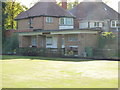
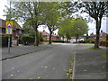
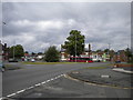
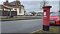
Photos of B28 9LD
Area Information
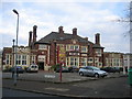
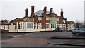
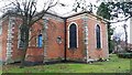
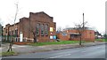
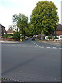
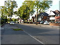
B28 9LD represents a specific residential cluster within the Hall Green North Ward, covering an area of just 4933 square metres and housing a population of 1902 people. This postcode sits in southeast Birmingham and forms part of a broader district recognised as one of the city's safest neighbourhoods. You will find housing here characterised by early twentieth-century to interwar architecture, often set within well-planted surroundings with low red brick boundary walls. The area retains distinct historical features, including the Church of the Ascension, a classical landmark dating back to 1704 with sections added in 1860. Nearby, The Friends Meeting House on Hamlet Road stands as a Victorian building originally constructed in 1883 by the Severne family before converting for Quaker use in the late 1920s. Another notable structure is Petersfield Court, an Art Deco block of 14 flats built in 1937 featuring rounded corner windows. The residential cluster feels established and mature, with resident employment rates slightly above the city average. Living in this postcode means residing in an environment that blends residential character with commercial history. The presence of these protected private residences and substantial villas suggests a community values stability and heritage. Daily life here is shaped by proximity to these significant landmarks and the quiet, tree-lined streets that define the ward's atmosphere.
- Area Type
- Postcode
- Area Size
- 4933 m²
- Population
- 1902
- Population Density
- 6279 people/km²
You are looking at a market defined by stability and tradition rather than rapid turnover. With 80 per cent of households owning their homes, B28 9LD is primarily an owner-occupied zone. The accommodation type data confirms that houses dominate the housing stock, offering spacious layouts typical of the early twentieth-century and interwar periods found in the ward. This contrasts sharply with high-rise rental blocks or terraced housing prevalent in other city areas. The prevalence of houses aligns with the presence of notable architectural features such as the fourteen villas of The Hamlet development and the 1937 Art Deco flats at Petersfield Court. When searching for homes in B28 9LD, you will encounter properties set back from roads with low red brick boundary walls. These homes often feature distinctive architectural details like massive chimneys, timbers, and leaded casements. The high ownership rate suggests fewer negative equity homes or distressed sales, pointing to a healthy local market. For buyers, this means a community where residents are likely to maintain their properties well. The small total area size of this specific postcode cluster means the available housing stock is limited and specific. Consequently, competition for individual houses may be higher than in broader suburbs. The fact that the majority of residents own their homes also implies that local councils rely heavily on council tax from this area rather than rental taxes.
House Prices in B28 9LD
Showing 7 properties
| Address | Type | Beds | Baths | Last Sale Price | Last Sale Date | |
|---|---|---|---|---|---|---|
| 660 Shirley Road, Hall Green, Birmingham, B28 9LD | Semi-detached | 4 | 2 | £484,500 | Dec 2023 | |
| 654 Shirley Road, Hall Green, Birmingham, B28 9LD | house | - | - | £412,000 | Mar 2021 | |
| 656 Shirley Road, Hall Green, Birmingham, B28 9LD | house | - | - | £330,000 | Aug 2013 | |
| 652 Shirley Road, Hall Green, Birmingham, B28 9LD | Semi-detached | 3 | 1 | £245,000 | Aug 2013 | |
| 648 Shirley Road, Hall Green, Birmingham, B28 9LD | Detached | 4 | 1 | £299,500 | Nov 2009 | |
| 662 Shirley Road, Hall Green, Birmingham, B28 9LD | Semi-detached | 5 | 4 | - | - | |
| 650 Shirley Road, Hall Green, Birmingham, B28 9LD | Terraced | - | - | - | - |
Energy Efficiency in B28 9LD
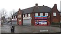
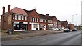
Life in B28 9LD offers convenient access to a range of retail and transport hubs within practical reach. Residents have five retail options nearby, including Waitrose Hall, Aldi Hall, and Co-op Northfield. These specific venues provide full grocery and household shopping needs without requiring a trip into central Birmingham. For commuting, there are five railway stations accessible, such as Hall Green Railway Station and Yardley Wood Railway Station. You can also reach five major metro locations, including Grand Central New Street, Corporation Street, and Bull Street, ensuring extensive public transport connectivity. The blend of residential and commercial character is evident in the local economy, which supports historic office spaces like Cambrai Court. This mix means you can find professional services alongside daily necessities. The area's history as The Hamlet development adds a layer of civic pride, with the Friends Meeting House serving as a focal point along Hamlet Road. Tree-lined streets and well-planted surroundings enhance the walking experience from home to local shops. Enjoying a meal or grabbing supplies is straightforward, as these amenities are just a short distance from your doorstep.
Amenities
Schools
Families living in B28 9LD have access to independent education options nearby. The primary school option listed for this location is Honeybourne School, which operates as an independent institution. While public sector schools are not listed in the available data for this specific postcode, the presence of an independent school suggests a community that values private education alternatives. Historically, the area contains Hall Green Junior School, located on School Road, which dates from 1893 and sits opposite The Friends Meeting House. This school, established three years after The Hamlet development began, reflects the centuries-long educational history of the ward. For parents considering moving to this area, the proximity to an independent school like Honeybourne School is a significant factor, though you should verify current Ofsted ratings through official government channels. The mix of historical institutions like Hall Green Junior School and modern independent providers indicates diverse choices for different family needs. The area's safety profile, with a crime risk score of 82 out of 100, supports an environment where children can play or walk to schools relative to safety standards. Living in B28 9LD means being within practical reach of these educational facilities.
| Rank | School | Type | Entry gender | Ages |
|---|
Explore more schools in this area
Go to Schools tabDemographics
The community in B28 9LD is predominantly composed of adults between the ages of 30 and 64, with a median age of 47 years. This age profile indicates a neighbourhood where families and established professionals have settled for the long term. You will find that 80 per cent of households own their homes, creating a deeply owner-occupied environment where residents are often invested in the long-term maintenance and improvement of their properties. The most common accommodation type consists of houses, reinforcing the traditional suburban character of the estate. Diversity is evident in the demographic make-up, where the predominant ethnic group falls under the asian_total classification. This reflects the established cultural mix found within the Hall Green North Ward. The high rate of home ownership combined with the older age demographic suggests a stable community with low transience. For those considering homes in this area, you would be joining a population that prioritises stability and local connection. The social fabric here is built on long-term residency rather than short-term stays. The 80 per cent ownership rate means fewer rental listings and a stronger sense of community ownership among neighbours.
Household Size
Accommodation Type
Tenure
Ethnic Group
Religion
Household Composition
Age
Household Deprivation
NS-SEC
Explore more demographic insights in this area
Go to Demographics tabPlanning
Planning Constraints
- Flood RiskPremium
- Ramsar Wetland SitesPremium
- Area of Outstanding Natural BeautyPremium
- Protected Nature ReservePremium
- Protected WoodlandPremium