Area Overview for B28 9JS
Photos of B28 9JS

Area Information
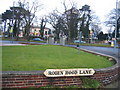
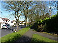
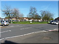
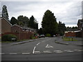
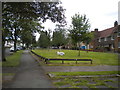
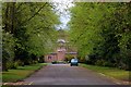
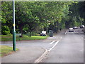
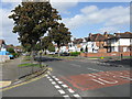
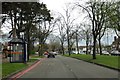
Living in B28 9JS means being part of Hall Green North Ward, a suburban area in southeast Birmingham with a population of 1,888. This small postcode cluster is defined by its residential character, with homes predominantly built in the early twentieth century, interwar period, and later infill developments. Tree-lined streets and low red brick boundary walls create a quiet, well-kept environment. The area is part of Hall Green, now recognised as one of Birmingham’s safest districts, blending historical architecture with modern amenities. Residents benefit from proximity to local schools, retail, and transport links. The ward’s history includes Victorian-era developments like The Hamlet, a private estate with distinctive villas, and the Friends Meeting House, a red-brick building originally built as a Reading Room. Daily life here is shaped by a mix of heritage and contemporary convenience, with low crime rates and minimal environmental constraints. The area’s compact size means a tight-knit community, where historic buildings coexist with modern infrastructure.
- Area Type
- Postcode
- Area Size
- Not available
- Population
- 1888
- Population Density
- 6065 people/km²
The property market in B28 9JS is characterised by a high rate of home ownership (70%), with houses forming the majority of the housing stock. This suggests a community of established residents rather than a rental-heavy market. The area’s small size means the housing stock is limited, with properties primarily consisting of older, well-constructed homes from the early twentieth century and interwar period. These include period villas with features like leaded casements and substantial chimneys, as well as later developments such as Petersfield Court, an Art Deco housing block. The focus on houses rather than flats or apartments may appeal to families seeking larger living spaces. Buyers should consider the limited availability of properties, as the area’s compact nature means few new developments. The existing stock offers a blend of historic character and practicality, though the market is likely competitive due to its desirability.
House Prices in B28 9JS
No properties found in this postcode.
Energy Efficiency in B28 9JS
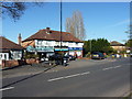
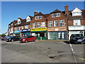
Daily life in B28 9JS is enriched by a mix of historical landmarks and modern amenities. Retail options include Aldi Hall, Waitrose Hall, and Tesco Robin, providing essentials within walking distance. The area’s transport links, such as Hall Green Railway Station and Spring Road Station, connect residents to Birmingham’s broader network. Cultural and historical sites like the Church of the Ascension (1704) and the Friends Meeting House (1883) add character, while Hall Green Junior School offers educational convenience. Parks and green spaces, though not explicitly named, are implied by the tree-lined streets and historic gardens. The presence of Petersfield Court and The Hamlet development reflects a blend of architectural styles. This mix of heritage and practicality creates a lifestyle that balances tradition with modern living, supported by accessible amenities and a strong sense of community.
Amenities
Schools
| Rank | School | Type | Entry gender | Ages |
|---|
Explore more schools in this area
Go to Schools tabDemographics
The population of B28 9JS is 1,888, with a median age of 47 and the majority of residents aged between 30 and 64. Home ownership is high, at 70%, reflecting a community of long-term residents. The accommodation type is predominantly houses, which aligns with the area’s suburban character. The predominant ethnic group is Asian_total, indicating a culturally diverse population. The age profile suggests a mature demographic, with fewer younger families compared to other parts of Birmingham. This profile influences the local economy, with employment rates slightly above the city average. The lack of specific deprivation data means the area’s quality of life is likely supported by stable housing and low crime rates. The presence of historic buildings and community institutions, such as Hall Green Junior School, further reinforces a sense of continuity and local identity.
Household Size
Accommodation Type
Tenure
Ethnic Group
Religion
Household Composition
Age
Household Deprivation
NS-SEC
Explore more demographic insights in this area
Go to Demographics tabPlanning
Planning Constraints
- Flood RiskPremium
- Ramsar Wetland SitesPremium
- Area of Outstanding Natural BeautyPremium
- Protected Nature ReservePremium
- Protected WoodlandPremium