Area Overview for B28 9EJ
Photos of B28 9EJ

Area Information
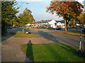
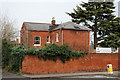
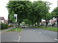
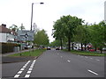
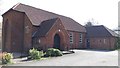
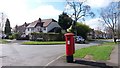
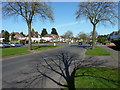
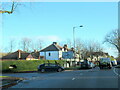
Living in B28 9EJ means being part of Hall Green North Ward, a suburban enclave within Birmingham’s southeast quadrant. With a population of 1,888, this small postcode area is defined by its low-rise housing stock, many of which date back to the early 20th century or interwar periods. The district’s character is shaped by tree-lined streets, red brick boundary walls, and a quiet residential rhythm. Hall Green is renowned as one of Birmingham’s safest areas, with employment rates slightly above the city average and unemployment figures below the regional norm. Its proximity to historic sites like the Friends Meeting House and the Church of the Ascension adds cultural depth, while modern amenities such as nearby supermarkets and rail links ensure practicality. Daily life here balances heritage with convenience, offering a peaceful alternative to Birmingham’s urban core without sacrificing accessibility to the city’s broader networks.
- Area Type
- Postcode
- Area Size
- Not available
- Population
- 1888
- Population Density
- 6065 people/km²
The property market in B28 9EJ is dominated by owner-occupied homes, with 70% of properties owned outright. This contrasts with areas where rental demand drives the market, suggesting a more settled demographic. The accommodation type is predominantly houses, not flats, which is typical of suburban Birmingham. This housing stock, largely built in the early 20th century or later, offers a mix of traditional and interwar-style homes, many with period features such as red brick facades and tree-lined gardens. For buyers, this means a limited supply of rental properties but a stable market for those seeking long-term ownership. The area’s small size means property choices are constrained, but the historical character and safety profile make it appealing for those prioritising security and architectural heritage over larger urban developments.
House Prices in B28 9EJ
No properties found in this postcode.
Energy Efficiency in B28 9EJ
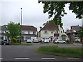
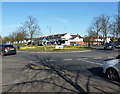
Life in B28 9EJ is enriched by a mix of retail, transport, and cultural amenities within easy reach. Nearby supermarkets such as Aldi Hall, Waitrose Hall, and Tesco Robin cater to daily shopping needs, while three railway stations—Yardley Wood, Hall Green, and Spring Road—offer frequent services to Birmingham’s core. The metro system, with stops like Grand Central New Street, provides additional mobility. The area’s historical charm is evident in landmarks like the Friends Meeting House (originally a Reading Room) and the Church of the Ascension, a 1704 structure with classical architecture. These sites, combined with tree-lined streets and low-traffic residential zones, create a relaxed, community-focused atmosphere. The proximity to schools, such as Hall Green Junior School, and the blend of heritage and modern convenience make daily life here both practical and culturally engaging.
Amenities
Schools
| Rank | School | Type | Entry gender | Ages |
|---|
Explore more schools in this area
Go to Schools tabDemographics
B28 9EJ’s population of 1,888 is predominantly adults aged 30–64, with a median age of 47. This suggests a mature, stable community where many residents are likely to be established professionals or families. Home ownership is high at 70%, indicating a strong presence of long-term residents and a lower proportion of renters. The area’s accommodation is primarily houses, not flats, which aligns with its suburban character. The predominant ethnic group is Asian, reflecting the broader demographic trends in Birmingham. While no specific deprivation data is provided, the high home ownership and low crime risk suggest a relatively affluent and secure environment. The age profile and ownership rates imply a community focused on stability, with fewer transient populations compared to other parts of the city.
Household Size
Accommodation Type
Tenure
Ethnic Group
Religion
Household Composition
Age
Household Deprivation
NS-SEC
Explore more demographic insights in this area
Go to Demographics tabPlanning
Planning Constraints
- Flood RiskPremium
- Ramsar Wetland SitesPremium
- Area of Outstanding Natural BeautyPremium
- Protected Nature ReservePremium
- Protected WoodlandPremium
- Crime RiskPremium