Area Overview for B28 8TA
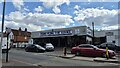
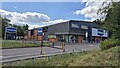
Photos of B28 8TA


Area Information
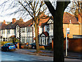
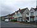
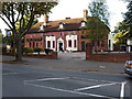
B28 8TA is a small, residential postcode area nestled in the southeast of Birmingham, within the Hall Green North Ward. With a population of just 1,799, it offers a quiet, suburban lifestyle characterised by tree-lined streets and historic architecture. The area’s charm lies in its blend of early 20th-century homes, interwar developments, and later infill properties, many of which are set back from roads behind low red brick walls. Hall Green is renowned as one of Birmingham’s safest districts, with employment rates slightly above the city average and unemployment figures below average. Residents enjoy proximity to local schools, retail hubs, and transport links, making it ideal for those seeking a stable, community-focused environment. The area’s historical roots, including Victorian-era buildings and Quaker heritage, add to its distinct character, while modern amenities ensure convenience for daily life. For buyers, B28 8TA represents a rare mix of heritage and practicality, with a strong sense of local identity and low crime rates.
- Area Type
- Postcode
- Area Size
- Not available
- Population
- 1799
- Population Density
- 8759 people/km²
B28 8TA is primarily an owner-occupied area, with 71% of homes owned by residents rather than rented. The housing stock consists almost entirely of houses, a rarity in modern Birmingham, where flats dominate. This suggests a market skewed toward long-term homeownership, with properties often featuring historical architectural details from the early 20th century, interwar periods, and later developments. The small size of the area means housing stock is limited, which could make the market competitive for buyers. However, the high home ownership rate and stable population indicate a reliable, low-turnover environment. For buyers, this means properties are likely to retain value, though availability may be constrained. The prevalence of houses also appeals to those seeking space and privacy, aligning with the area’s suburban character.
House Prices in B28 8TA
No properties found in this postcode.
Energy Efficiency in B28 8TA
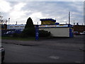
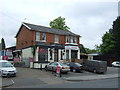
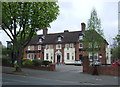
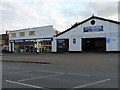
Living in B28 8TA offers a blend of everyday convenience and historical richness. Nearby retail options include Tesco Hall, Asda Sparkhill, and Co-op Sparkhill, providing essential shopping within walking distance. The area’s transport links ensure easy access to Birmingham’s cultural and commercial hubs, while its suburban layout fosters a relaxed pace of life. Notable landmarks include the Friends Meeting House on Hamlet Road, a Victorian building with red brick detailing, and Hall Green Junior School, established in 1893. Tree-lined streets and early 20th-century architecture create a sense of continuity with the past. Residents can enjoy both practical amenities and the quiet charm of a historically significant neighbourhood, making daily life both functional and enriched by heritage.
Amenities
Schools
| Rank | School | Type | Entry gender | Ages |
|---|
Explore more schools in this area
Go to Schools tabDemographics
The population of B28 8TA is predominantly adults aged 30–64, with a median age of 47. This suggests a mature, established community, likely with long-term residents and families. Home ownership is high at 71%, indicating a stable housing market and a focus on long-term residency rather than rental turnover. The area’s accommodation is largely composed of houses, reflecting a preference for single-family living over flats or apartments. The predominant ethnic group is Asian, though specific subgroups are not detailed. This demographic profile implies a community with strong family ties and a potential demand for local services tailored to older and middle-aged residents. The absence of significant deprivation data suggests a generally high quality of life, with access to amenities and infrastructure supporting daily needs.
Household Size
Accommodation Type
Tenure
Ethnic Group
Religion
Household Composition
Age
Household Deprivation
NS-SEC
Explore more demographic insights in this area
Go to Demographics tabPlanning
Planning Constraints
- Flood RiskPremium
- Ramsar Wetland SitesPremium
- Area of Outstanding Natural BeautyPremium
- Protected Nature ReservePremium
- Protected WoodlandPremium