Area Overview for B28 8LN
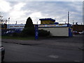
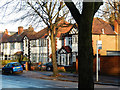
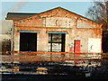
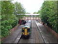
Photos of B28 8LN
Area Information
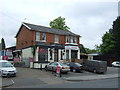
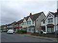
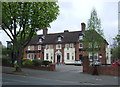
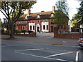
B28 8LN is a small residential postcode area in southeast Birmingham, part of the Hall Green North Ward. With a population of nearly 2,000, it is a compact, suburban enclave characterised by tree-lined streets and early 20th-century housing. The area blends historical architecture with modern convenience, offering a quiet alternative to Birmingham’s busier districts. Residents benefit from proximity to both urban amenities and green spaces, with low crime rates and a strong sense of community. The ward’s safe environment and mix of historic buildings, such as the Church of the Ascension and the Friends Meeting House, reflect its heritage as a well-established suburb. Daily life here is defined by local shops, rail links, and a family-friendly atmosphere, making it appealing to those seeking a balance between tradition and accessibility. The area’s small size means it is ideal for those prioritising a close-knit community over sprawling developments, with homes often set back from roads in well-maintained settings.
- Area Type
- Postcode
- Area Size
- Not available
- Population
- 1995
- Population Density
- 7202 people/km²
The property market in B28 8LN is dominated by owner-occupied homes, with 65% of properties owned by residents rather than rented. The accommodation type is primarily houses, which is unusual for urban areas and suggests a focus on single-family living. This makes the area attractive to buyers seeking traditional homes with garden space, though the small postcode size means the housing stock is limited. Properties are largely from the early 20th century and interwar periods, offering character features such as red brick facades and tree-lined streets. The high home ownership rate indicates a stable market with long-term residents, but the small area may limit availability for new buyers. Those considering the area should note the historical nature of the housing stock, which may require modernisation, and the proximity to Birmingham’s urban amenities, which could enhance property value.
House Prices in B28 8LN
No properties found in this postcode.
Energy Efficiency in B28 8LN
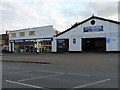
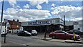
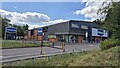
Living in B28 8LN offers a blend of suburban tranquillity and urban accessibility. Nearby amenities include five retail outlets, such as Tesco Hall and Asda Merestones, providing everyday shopping needs. The area’s proximity to rail and metro stations, including Hall Green and Grand Central New Street, ensures easy access to Birmingham’s transport network. Residents also benefit from historical landmarks like the Church of the Ascension and the Friends Meeting House, which contribute to the area’s cultural character. Tree-lined streets and well-maintained properties create a pleasant environment, while the absence of major planning constraints allows for a relaxed lifestyle. The mix of retail, transport, and heritage sites supports a convenient, family-friendly atmosphere, ideal for those seeking a balance between community and connectivity.
Amenities
Schools
The nearest school to B28 8LN is Yorkmead Junior and Infant School, a primary school with an Ofsted rating of ‘good’. This provides a reliable option for families with young children, though no secondary schools are listed in the data. The presence of a primary school with a positive rating suggests a focus on early education, which is crucial for families prioritising local schooling. However, parents may need to look beyond the immediate area for secondary education. The school’s rating indicates a satisfactory standard of teaching and facilities, though further details on its curriculum or size are not provided. For families, the availability of a primary school with a good rating is a key advantage, but the absence of secondary options may require planning for commuting or private schooling.
| Rank | School | Type | Entry gender | Ages |
|---|
Explore more schools in this area
Go to Schools tabDemographics
The population of B28 8LN is 1,995, with a median age of 47 and the majority of residents aged 30–64. This suggests a mature, stable community with a strong presence of working-age adults. Home ownership is high at 65%, indicating a preference for long-term residency over rental properties. The accommodation type is predominantly houses, reflecting a residential character distinct from high-density housing. The predominant ethnic group is Asian_total, which shapes the cultural and social dynamics of the area. While no specific deprivation data is provided, the high home ownership rate and average employment levels suggest a relatively stable economic environment. The age profile and ownership figures indicate a community focused on family living, with limited turnover of properties. This demographic profile supports a cohesive, established neighbourhood with a clear identity.
Household Size
Accommodation Type
Tenure
Ethnic Group
Religion
Household Composition
Age
Household Deprivation
NS-SEC
Explore more demographic insights in this area
Go to Demographics tabPlanning
Planning Constraints
- Flood RiskPremium
- Ramsar Wetland SitesPremium
- Area of Outstanding Natural BeautyPremium
- Protected Nature ReservePremium
- Protected WoodlandPremium