Area Overview for B28 8AH
Photos of B28 8AH
Area Information
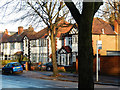
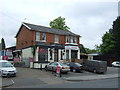
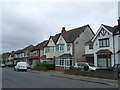
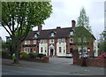
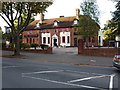
Living in B28 8AH means settling in a small, residential postcode area within Birmingham’s Hall Green North Ward. With a population of 2047, it is a compact community defined by its suburban character and historical architecture. The area features early twentieth-century homes, interwar properties, and later developments, many set back from roads with low red brick walls and tree-lined streets. Hall Green North Ward is part of a broader district recognised as one of Birmingham’s safest, offering a blend of residential tranquillity and proximity to urban amenities. Daily life here is shaped by its low crime rates, well-maintained housing stock, and access to nearby schools, retail, and transport links. The area’s charm lies in its mix of historical landmarks, such as the Church of the Ascension (1704), and modern conveniences, making it appealing to families and professionals seeking a balanced lifestyle. Its compact size means residents can walk to key services, while the surrounding Birmingham offers broader opportunities.
- Area Type
- Postcode
- Area Size
- Not available
- Population
- 2047
- Population Density
- 4952 people/km²
The property market in B28 8AH is characterised by high home ownership (72%) and a predominance of houses over flats. This suggests a community of long-term residents, with properties largely concentrated in early twentieth-century and interwar-era housing. The area’s architecture includes features such as low red brick boundary walls, tree-lined streets, and historic developments like Petersfield Court (1937) and The Hamlet (1883–1893), which add to the area’s distinctiveness. For buyers, this means a focus on owner-occupied homes with historical or architectural appeal, rather than a rental market. The compact size of the postcode area means properties are closely clustered, with limited scope for new developments. Buyers should consider the age of properties, which may require maintenance, and the strong sense of community that comes with living in a stable, low-turnover neighbourhood.
House Prices in B28 8AH
No properties found in this postcode.
Energy Efficiency in B28 8AH
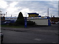
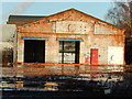
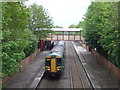
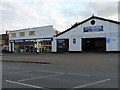
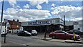
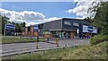
Daily life in B28 8AH is enriched by nearby amenities that blend practicality with historical character. Retail options include major supermarkets such as Tesco Hall, Co-op Sparkhill, and Waitrose Hall, ensuring easy access to groceries and daily essentials. The area’s proximity to rail stations like Hall Green and Spring Road, as well as metro stops like Corporation Street, provides seamless connections to Birmingham’s business districts and cultural hubs. The suburban setting includes tree-lined streets and historic buildings like the Church of the Ascension (1704), offering a sense of heritage. While parks are not explicitly mentioned, the area’s low-density housing and green spaces suggest opportunities for outdoor recreation. The mix of retail, transport, and historical landmarks creates a lifestyle that balances convenience with a distinct sense of place.
Amenities
Schools
The nearest schools to B28 8AH include Hall Green School, which operates as both a primary school and an academy with an Ofsted rating of ‘good’. This dual role offers families access to early education and secondary schooling within the same institution, though the exact curriculum and facilities are not detailed in the data. The presence of a primary school and an academy suggests a range of educational options, though the absence of independent or specialist schools may be a consideration for some families. The school’s location opposite the Friends Meeting House (1883) highlights the area’s historical and cultural significance. Parents should verify specific Ofsted reports for detailed insights into teaching quality and student outcomes.
| Rank | School | Type | Entry gender | Ages |
|---|
Explore more schools in this area
Go to Schools tabDemographics
B28 8AH has a median age of 47, with the majority of residents aged between 30 and 64. This suggests a community of established professionals and families, reflected in the 72% home ownership rate. The area is predominantly composed of houses, rather than flats or apartments, indicating a focus on traditional family homes. The predominant ethnic group is Asian, which shapes the cultural fabric of the neighbourhood. While specific deprivation data is not provided, the high home ownership and stable age profile suggest a relatively affluent and settled population. The absence of significant rental properties implies a community prioritising long-term residency over transient tenancy. This demographic profile aligns with the area’s reputation as a safe, family-oriented suburb with historical character and modern amenities.
Household Size
Accommodation Type
Tenure
Ethnic Group
Religion
Household Composition
Age
Household Deprivation
NS-SEC
Explore more demographic insights in this area
Go to Demographics tabPlanning
Planning Constraints
- Flood RiskPremium
- Ramsar Wetland SitesPremium
- Area of Outstanding Natural BeautyPremium
- Protected Nature ReservePremium
- Protected WoodlandPremium