Area Overview for B28 8AG
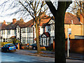
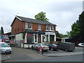
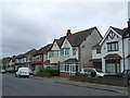
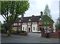
Photos of B28 8AG


Area Information
B28 8AG is a small residential postcode cluster in southeast Birmingham, part of the broader Hall Green area, which is now one of the city’s safest districts. With a population of 2,047, it is a compact, suburban community characterised by low red brick boundary walls, tree-lined streets, and homes dating from the early twentieth century to interwar periods. The area blends historical architecture with modern living, offering a quiet, family-friendly environment. Residents benefit from proximity to both urban and rural features, with nearby rail and metro links providing easy access to Birmingham’s core. The ward’s safe reputation, combined with its mix of historic buildings and contemporary amenities, makes it appealing to those seeking stability and a sense of community. Daily life here is shaped by its residential focus, with local shops, schools, and transport options within walking distance. The area’s heritage, including Victorian villas and Art Deco housing blocks, adds to its distinct character, while its low crime rates and well-maintained infrastructure cater to a range of lifestyles.
- Area Type
- Postcode
- Area Size
- Not available
- Population
- 2047
- Population Density
- 4952 people/km²
B28 8AG is predominantly a home-owning area, with 72% of residents owning their properties. The accommodation type is primarily houses, which contrasts with areas dominated by flats or rental properties. This suggests a market skewed towards owner-occupied homes, likely attracting families or long-term residents seeking stability. The presence of older, historic properties—such as early twentieth-century villas and interwar housing—adds character but may also mean limited new developments. Given the small size of the postcode area, the housing stock is likely limited, with properties concentrated in a compact cluster. Buyers should consider the age of homes, as many date back to the early 1900s or later infill developments. The area’s safety and proximity to amenities may make it appealing for those prioritising security and convenience, though the limited size means competition for available properties could be high.
House Prices in B28 8AG
No properties found in this postcode.
Energy Efficiency in B28 8AG
Living in B28 8AG offers a blend of convenience and character, with nearby amenities that support daily life. Retail options include Tesco Hall, Co-op Sparkhill, and Lidl Acocks, providing essential shopping within walking distance. Public transport is well-served by five rail stations and three metro stops, enabling easy travel to Birmingham’s core or surrounding areas. The area’s historical architecture, including Victorian villas and Art Deco housing, contributes to a distinct suburban atmosphere. Parks and green spaces, though not explicitly named, are implied by the tree-lined streets and historic properties, suggesting opportunities for outdoor leisure. The presence of the Friends Meeting House and Church of the Ascension adds cultural and historical depth, while the safe environment fosters a sense of community. Residents benefit from a mix of practical amenities and heritage, making it suitable for those valuing both convenience and tradition.
Amenities
Schools
The nearest schools to B28 8AG include Hall Green School, which operates as both a primary school and an academy with a good Ofsted rating. This dual role provides families with a range of educational options, from early years schooling to secondary-level education. The presence of a well-rated academy suggests a focus on academic standards and resources, which can be a significant draw for parents. However, the data does not specify the number of students or additional schools in the immediate vicinity. The proximity of Hall Green Junior School, established in 1893, adds historical value to the area’s educational landscape. Families seeking a mix of traditional and modern schooling may find this combination beneficial, though the absence of other schools in the data means the full range of options remains unclear.
| Rank | School | Type | Entry gender | Ages |
|---|
Explore more schools in this area
Go to Schools tabDemographics
The population of B28 8AG has a median age of 47, with the most common age group being adults aged 30–64. This suggests a community of established residents, many of whom are likely to be homeowners. Home ownership in the area is high at 72%, indicating a stable, long-term demographic. The predominant accommodation type is houses, which aligns with the area’s suburban layout and older housing stock. The dominant ethnic group is Asian_total, reflecting a culturally diverse community. The absence of specific deprivation data means the area’s socioeconomic profile is not explicitly detailed, but the high home ownership rate and presence of historic properties suggest a relatively affluent or stable environment. The age profile implies a mix of working-age individuals and retirees, with limited data on household types or family structures.
Household Size
Accommodation Type
Tenure
Ethnic Group
Religion
Household Composition
Age
Household Deprivation
NS-SEC
Explore more demographic insights in this area
Go to Demographics tabPlanning
Planning Constraints
- Flood RiskPremium
- Ramsar Wetland SitesPremium
- Area of Outstanding Natural BeautyPremium
- Protected Nature ReservePremium
- Protected WoodlandPremium