Area Overview for B28 0LQ
Photos of B28 0LQ

Area Information
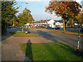
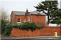
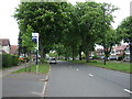
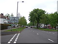
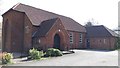
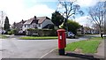
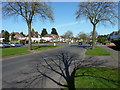
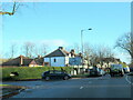
Living in B28 0LQ means inhabiting a small, tightly knit residential cluster in southeast Birmingham, historically part of Worcestershire. With a population of 1,817, this area blends suburban tranquillity with proximity to the city’s infrastructure. Hall Green South, where B28 0LQ falls, is a ward with a population density of 4,867 per km², shaped by its roots in Yardley parish. The area is notable for landmarks like Sarehole Mill, a historic watermill linked to J.R.R. Tolkien’s childhood, and the Church of the Ascension, built in 1704. Daily life here is characterised by low crime rates, excellent broadband, and easy access to rail networks. Residents benefit from a mix of heritage and modern convenience, with a community described as safe and vibrant. The postcode’s compact size means it’s ideal for those seeking a quieter lifestyle without sacrificing connectivity to Birmingham’s cultural and economic hubs.
- Area Type
- Postcode
- Area Size
- Not available
- Population
- 1817
- Population Density
- 4178 people/km²
The property market in B28 0LQ is dominated by owner-occupied homes, with 90% of residents living in houses rather than flats or rental properties. This suggests a stable, long-term demographic with a preference for private housing. The small postcode area means the housing stock is limited but likely of good quality, given the suburban setting and low crime rates. For buyers, this translates to a market where properties are not frequently available, but when they are, they tend to attract strong interest from families or professionals seeking security. The absence of high-rise or rental-focused developments indicates a focus on traditional family homes. Proximity to rail networks and amenities like Tesco Robin and Waitrose Hall may further enhance the appeal of properties here, particularly for those prioritising convenience and safety.
House Prices in B28 0LQ
No properties found in this postcode.
Energy Efficiency in B28 0LQ
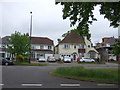
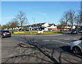
Life in B28 0LQ is shaped by its proximity to retail, dining, and transport hubs. The area’s retail offerings include Tesco Robin, Aldi Hall, and Waitrose Hall, providing a range of grocery and convenience options. For commuters, rail stations like Yardley Wood and Hall Green offer direct links to Birmingham’s business districts, while metro stops at Grand Central New Street and Corporation Street connect to the city’s transport network. The area’s historical charm is complemented by its practicality, with landmarks like Sarehole Mill and the Church of the Ascension adding cultural depth. Though specific parks are not listed in the data, the low crime rate and suburban layout suggest a peaceful environment for daily walks or leisure. The blend of heritage, retail, and transport makes B28 0LQ appealing to those seeking a balanced lifestyle.
Amenities
Schools
| Rank | School | Type | Entry gender | Ages |
|---|
Explore more schools in this area
Go to Schools tabDemographics
The community in B28 0LQ is predominantly composed of adults aged 30–64, with a median age of 47. This suggests a mature, stable population, likely with established careers and families. Home ownership is exceptionally high at 90%, reflecting a strong preference for private residence over rental properties. The accommodation type is primarily houses, which aligns with the suburban character of the area. The predominant ethnic group is White, though specific data on diversity or deprivation is not provided. The age profile indicates a low proportion of young families or retirees, which may influence local services and amenities. The absence of data on deprivation means no direct conclusions can be drawn about economic challenges, but the high home ownership and safety scores imply a relatively affluent, settled community.
Household Size
Accommodation Type
Tenure
Ethnic Group
Religion
Household Composition
Age
Household Deprivation
NS-SEC
Explore more demographic insights in this area
Go to Demographics tabPlanning
Planning Constraints
- Flood RiskPremium
- Ramsar Wetland SitesPremium
- Area of Outstanding Natural BeautyPremium
- Protected Nature ReservePremium
- Protected WoodlandPremium