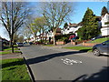
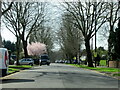
Area Overview for B28 0BW
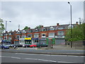
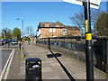
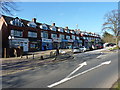
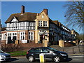
Photos of B28 0BW

Area Information
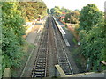
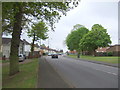
B28 0BW is a small residential postcode area in southeast Birmingham, nestled within the historically distinct Hall Green district. With a population of 1909, it reflects a compact, suburban character typical of the broader Hall Green ward, which once fell under Worcestershire. The area is defined by its proximity to landmarks such as Sarehole Mill, a historic watermill linked to J.R.R. Tolkien’s childhood, and the Church of the Ascension, a 1704 structure that stands as one of Birmingham’s oldest surviving classical churches. Daily life here blends quiet residential living with accessible urban amenities. The community is predominantly composed of adults aged 30–64, with a median age of 47, suggesting a mature, stable demographic. Residents benefit from proximity to multiple railway stations, including Yardley Wood and Hall Green, as well as retail hubs like Tesco Robin and Aldi Hall. The area’s reputation as one of Birmingham’s safest districts, supported by a crime risk score of 73, adds to its appeal for families and professionals seeking a secure, low-stress environment.
- Area Type
- Postcode
- Area Size
- Not available
- Population
- 1909
- Population Density
- 3869 people/km²
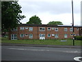
B28 0BW is primarily an owner-occupied area, with 71% of homes owned by residents rather than rented. The accommodation type is predominantly houses, reflecting the suburban layout of the Hall Green district. This contrasts with areas dominated by flats or apartments, offering a more private, spacious living environment. The small size of the postcode area means the housing stock is limited, potentially making it a niche market for buyers seeking properties in a historically significant part of Birmingham. The high home ownership rate suggests a community of long-term residents, which may influence property values and desirability. For buyers, the focus on houses rather than rental properties indicates a market suited to those prioritising ownership over flexibility, though the limited scale of the area may require considering nearby postcodes for broader options.
House Prices in B28 0BW
No properties found in this postcode.
Energy Efficiency in B28 0BW
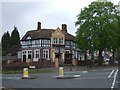
Living in B28 0BW offers a blend of convenience and historical richness. Residents have access to retail options like Tesco Robin, Aldi Hall, and Waitrose Hall, ensuring everyday shopping needs are met within walking or short driving distance. The area’s proximity to railway stations such as Hall Green and Shirley facilitates easy travel to Birmingham’s business districts or cultural centres. Historically, the district is anchored by Sarehole Mill, a 18th-century watermill tied to J.R.R. Tolkien’s early life, and the Church of the Ascension, a notable architectural landmark. While the area lacks large parks, its suburban layout provides a quieter, more residential atmosphere. The presence of nearby leisure venues, including former sports stadiums repurposed for housing, hints at evolving community spaces. This mix of heritage, retail, and transport access creates a lifestyle that balances tradition with modern practicality.
Amenities
Schools
| Rank | School | Type | Entry gender | Ages |
|---|
Explore more schools in this area
Go to Schools tabDemographics
The population of B28 0BW is 1909, with a median age of 47, indicating a community skewed towards middle-aged adults. The most common age range is 30–64 years, reflecting a demographic of established professionals and families. Home ownership in the area is high at 71%, suggesting a stable, long-term resident base. The predominant accommodation type is houses, which aligns with the suburban character of the ward. The predominant ethnic group is White, though no specific data on diversity or deprivation levels is provided. The area’s low crime risk score of 73, combined with its historical and cultural assets, contributes to a quality of life that balances safety with access to heritage sites like Sarehole Mill. This profile suggests a community focused on stability, with limited turnover and a strong sense of local identity.
Household Size
Accommodation Type
Tenure
Ethnic Group
Religion
Household Composition
Age
Household Deprivation
NS-SEC
Explore more demographic insights in this area
Go to Demographics tabPlanning
Planning Constraints
- Flood RiskPremium
- Ramsar Wetland SitesPremium
- Area of Outstanding Natural BeautyPremium
- Protected Nature ReservePremium
- Protected WoodlandPremium