Area Overview for B27 6NZ
Photos of B27 6NZ


Area Information
B27 6NZ is a small, densely populated residential cluster in the heart of Solihull, England. Covering just 1.1 hectares, it is home to 1,342 people, translating to a population density of 121,848 people per square kilometre. This compact area retains the character of a suburban village, with roots tracing back to the medieval manor of Ulverlei, later known as Oulton. Despite its proximity to Solihull, it maintains a distinct identity, shaped by its historical ties to the region’s agricultural past and its transformation into a residential hub after the railway arrived in 1869. Daily life here is defined by its proximity to key transport links, including Olton and Acocks Green railway stations, and its access to retail and leisure amenities. The area’s compact size means residents are within easy reach of Birmingham’s broader networks, yet it offers a quieter, more community-focused environment. With a median age of 47 and a population skewed toward adults aged 30–64, B27 6NZ is a stable, family-oriented neighbourhood where many residents own their homes. Its blend of historical significance and modern convenience makes it a unique spot for those seeking a balanced lifestyle.
- Area Type
- Postcode
- Area Size
- 1.1 hectares
- Population
- 1342
- Population Density
- 4369 people/km²
The property market in B27 6NZ is characterised by high home ownership (70%) and a focus on houses rather than flats or apartments. This suggests a predominantly owner-occupied area, likely attracting families and long-term residents seeking stability. The compact size of the postcode (1.1 hectares) means housing stock is limited, with properties concentrated in a small footprint. The prevalence of houses indicates a traditional suburban layout, potentially offering larger living spaces compared to denser urban areas. For buyers, this presents both opportunities and constraints: the area is likely to have a strong sense of community but limited scope for new developments. Proximity to Solihull and its transport links may enhance property value, though the small size of B27 6NZ means competition for available homes could be intense. Investors should consider the local demand for family homes and the area’s historical appeal as a residential enclave.
House Prices in B27 6NZ
No properties found in this postcode.
Energy Efficiency in B27 6NZ
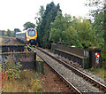
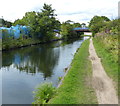
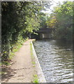
Living in B27 6NZ means easy access to a range of amenities within practical reach. Retail options include major supermarkets like Tesco Solihull, Farmfoods Acocks, and Morrisons Acocks, ensuring convenience for daily shopping. The area’s railway stations—Olton, Acocks Green, and Spring Road—provide direct links to Birmingham’s transport network, while proximity to Birmingham International Airport makes it ideal for frequent travellers. For leisure, Olton Mere, a significant body of open water, offers recreational opportunities, and the surrounding woodland supports biodiversity. The historical St Margaret’s Church, a Grade II listed building, adds cultural value. The compact size of the postcode means amenities are closely clustered, reducing the need for long commutes. This blend of retail, transport, and green spaces creates a lifestyle that balances convenience with a sense of community, making it appealing for families and professionals alike.
Amenities
Schools
| Rank | School | Type | Entry gender | Ages |
|---|
Explore more schools in this area
Go to Schools tabDemographics
The population of B27 6NZ is predominantly adults aged 30–64, with a median age of 47. This suggests a mature, settled community with strong family ties and a focus on long-term residency. Home ownership is high, at 70%, indicating a stable housing market and a preference for private property over rentals. The area is composed mainly of houses, reflecting a traditional suburban layout rather than high-density housing. The predominant ethnic group is White, though specific diversity statistics are not provided in the data. The age profile and ownership rates suggest a community that prioritises security and continuity, with fewer transient residents. The absence of detailed deprivation data means it is difficult to assess socioeconomic challenges, but the high home ownership and low crime risk (Safety Score: 84/100) imply a relatively affluent and safe environment. This demographic profile aligns with a neighbourhood where families and professionals coexist, with limited pressure from younger or elderly populations.
Household Size
Accommodation Type
Tenure
Ethnic Group
Religion
Household Composition
Age
Household Deprivation
NS-SEC
Explore more demographic insights in this area
Go to Demographics tabPlanning
Planning Constraints
- Flood RiskPremium
- Ramsar Wetland SitesPremium
- Area of Outstanding Natural BeautyPremium
- Protected Nature ReservePremium
- Protected WoodlandPremium