Area Overview for B27 6GP
Photos of B27 6GP


Area Information
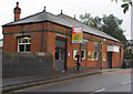
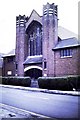
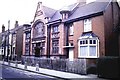
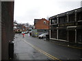
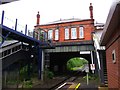
Living in B27 6GP, a small residential cluster in southeast Birmingham, means inhabiting a historic suburb with a distinct character. The area, known as Acocks Green, traces its roots to medieval times, evolving from rural hamlets into a suburban hub. With a population of 1706, it is compact yet well-connected, centred around the Warwick Road roundabout, which once marked the heart of the former Westley Brook hamlet. The area’s charm lies in its listed buildings, such as Yardley Road Baptist Church, and its mix of older homes and interwar housing. Residents benefit from proximity to Birmingham’s transport networks, including nearby railway stations and the city’s international airport. Daily life here balances suburban tranquillity with urban accessibility, making it appealing to those seeking a settled, community-focused environment without sacrificing convenience.
- Area Type
- Postcode
- Area Size
- Not available
- Population
- 1706
- Population Density
- 5961 people/km²
The property market in B27 6GP is characterised by a high proportion of owner-occupied homes, with 58% of residents living in their own properties. The accommodation type is predominantly houses, reflecting the area’s suburban layout and historical development as a residential suburb. This mix of older and interwar housing suggests a limited but distinct housing stock, with fewer high-rise or modern developments. For buyers, this means a focus on family-friendly, traditional homes rather than a rental market. The small size of the area and its proximity to Birmingham’s amenities make it a niche market, where properties are likely to be in demand for their historic character and established community feel.
House Prices in B27 6GP
No properties found in this postcode.
Energy Efficiency in B27 6GP
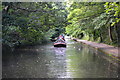
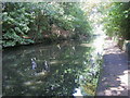
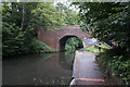
The lifestyle in B27 6GP is shaped by its suburban setting and accessible amenities. Residents can shop at nearby retail outlets such as Farmfoods Acocks and Morrisons Acocks, while the Warwick Road roundabout serves as a local hub. The area’s historic character, including listed buildings and remnants of 19th-century infrastructure like the Warwick and Birmingham Canal, adds to its distinctiveness. Though the data does not specify parks or leisure facilities, the proximity to rail stations and the area’s integration into Birmingham’s transport network suggest easy access to wider recreational opportunities. The blend of historic architecture and modern convenience makes daily life here both rooted in tradition and adaptable to contemporary needs.
Amenities
Schools
B27 6GP is served by a range of primary and independent schools, offering families diverse educational options. Cottesbrooke Infant School and Cottesbrooke Infant and Nursery School are state-funded primaries, while Eastbourne House School and Kimichi School are independent institutions. Kimichi School holds a ‘good’ Ofsted rating, indicating strong performance. The presence of both academy and independent schools provides flexibility, whether parents seek state education with local community ties or private schooling. This mix ensures families can choose between affordable, publicly funded options and higher-fee independent institutions, depending on their priorities.
| Rank | School | Type | Entry gender | Ages |
|---|
Explore more schools in this area
Go to Schools tabDemographics
The population of B27 6GP has a median age of 47, with the majority of residents falling within the 30-64 age range. This suggests a mature, stable community with a focus on family life and long-term residency. Home ownership stands at 58%, indicating a significant proportion of residents live in their own homes, often in traditional houses rather than flats. The predominant ethnic group is White, reflecting the area’s historical demographic patterns. The absence of specific data on deprivation or diversity beyond ethnicity means the community’s social composition remains largely defined by its older, owner-occupied housing stock. This profile aligns with the area’s reputation as a long-standing residential suburb, where generational continuity is a notable feature.
Household Size
Accommodation Type
Tenure
Ethnic Group
Religion
Household Composition
Age
Household Deprivation
NS-SEC
Explore more demographic insights in this area
Go to Demographics tabPlanning
Planning Constraints
- Flood RiskPremium
- Ramsar Wetland SitesPremium
- Area of Outstanding Natural BeautyPremium
- Protected Nature ReservePremium
- Protected WoodlandPremium