Area Overview for B27 6AS
Photos of B27 6AS

Area Information
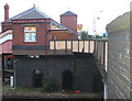
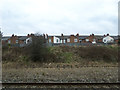
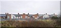
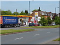
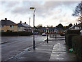
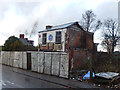
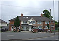
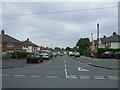
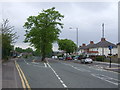
B27 6AS is a small residential postcode in southeast Birmingham, part of the historic Acocks Green suburb. With a population of 1,789, it retains a suburban character shaped by its origins as a 14th-century rural hamlet. The area expanded in the 18th and 19th centuries with infrastructure like the Warwick Road and the Birmingham to Oxford Railway, which spurred growth. Today, it is a quiet residential cluster with a distinct sense of community. The Warwick Road roundabout serves as a modern hub, linking to Shirley and Westley Roads, which were once part of the ancient Westley Brook hamlet. Listed buildings, such as Yardley Road Baptist Church and 19th-century cottages along Arden Road, hint at its heritage. Despite its small size, B27 6AS offers a blend of historic charm and practical modern amenities, making it a niche area for those seeking a settled, low-density living environment. Its proximity to Birmingham’s core, combined with a low flood risk and minimal planning constraints, positions it as a stable, if unassuming, residential choice.
- Area Type
- Postcode
- Area Size
- Not available
- Population
- 1789
- Population Density
- 2149 people/km²
B27 6AS is predominantly a home-owning area, with 50% of residents owning their properties. The accommodation type is primarily houses, which is uncommon in many urban areas but aligns with its suburban character. This suggests a market skewed towards owner-occupiers rather than renters, though the relatively low population density (1,789 people in a small postcode) means the housing stock is limited in scale. The presence of listed buildings and historic homes, such as those along Arden Road, adds unique value to properties, though they may require maintenance. For buyers, the area’s small size means competition could be fierce, and the immediate surroundings may offer limited alternatives. The focus on houses rather than flats also appeals to those seeking space and privacy. However, the high crime risk score of 25/100 might deter some buyers, particularly those concerned about security. Overall, the property market here is niche, catering to those who prioritise historical character and a quieter lifestyle over proximity to central Birmingham.
House Prices in B27 6AS
No properties found in this postcode.
Energy Efficiency in B27 6AS
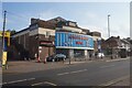
Daily life in B27 6AS is shaped by its proximity to practical amenities. Residents have access to five retail outlets, including Lidl in Yardley and Asda in Merestones, providing essential shopping options. The area’s railway stations, such as Acocks Green and Tyseley, offer frequent services to Birmingham’s business districts and beyond. For leisure, the historic Warwick Road roundabout serves as a social hub, linking to Shirley and Westley Roads, which retain a village-like atmosphere. Acocks Green Primary School, established in 1908, caters to around 480 pupils, making it a focal point for families. While parks and green spaces are not explicitly listed, the area’s low flood risk and absence of protected nature reserves suggest some open spaces may exist. The character of B27 6AS is defined by its quiet, suburban feel, with a mix of historic buildings and modern convenience. However, the lack of large-scale leisure facilities means residents may need to travel slightly further for activities like cinemas or larger retail centres.
Amenities
Schools
| Rank | School | Type | Entry gender | Ages |
|---|
Explore more schools in this area
Go to Schools tabDemographics
The population of B27 6AS is 1,789, with a median age of 47, indicating a mature demographic. The most common age group is adults aged 30–64, suggesting a community of established professionals and families. Home ownership stands at 50%, with houses being the predominant accommodation type. This contrasts with areas dominated by flats or rental properties, reflecting a more settled, long-term resident base. The predominant ethnic group is White, though specific diversity metrics are not provided. The age profile and ownership figures suggest a stable, low-turnover community where residents are likely to have built their homes rather than rented. The absence of significant deprivation data means quality of life is inferred from infrastructure: broadband and mobile connectivity are excellent, and nearby amenities include retail and transport hubs. However, the high crime risk score of 25/100 indicates safety could be a concern for some, particularly for families or those prioritising security.
Household Size
Accommodation Type
Tenure
Ethnic Group
Religion
Household Composition
Age
Household Deprivation
NS-SEC
Explore more demographic insights in this area
Go to Demographics tabPlanning
Planning Constraints
- Flood RiskPremium
- Ramsar Wetland SitesPremium
- Area of Outstanding Natural BeautyPremium
- Protected Nature ReservePremium
- Protected WoodlandPremium