Area Overview for B26 3SF
Photos of B26 3SF

Area Information
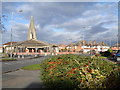
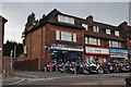
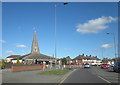
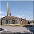
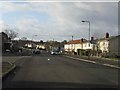
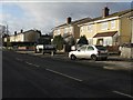
Living in B26 3SF, a small residential cluster in east Birmingham, offers a quiet suburban existence within the West Midlands region. The area, historically part of Warwickshire, sits near the border with Solihull, blending urban proximity with a sense of local identity. With a population of 1,727, it is a tight-knit community where the architecture reflects older, more traditional housing stock. The postcode covers a compact area, making it ideal for those seeking a manageable, low-density environment. Sheldon’s history stretches back to the Domesday Book, with St Giles Church standing as a 14th-century landmark. Daily life here is shaped by its proximity to retail, transport, and green spaces, though the area’s character is defined by its modest scale and the presence of notable historical sites like the 12th-century chancel arch at St Giles. Residents benefit from easy access to Birmingham’s infrastructure while retaining a distinct local flavour. The area’s small size means amenities are within practical reach, and the community’s demographic profile—primarily middle-aged homeowners—suggests a stable, family-oriented environment.
- Area Type
- Postcode
- Area Size
- Not available
- Population
- 1727
- Population Density
- 3414 people/km²
The property market in B26 3SF is characterised by a high rate of home ownership (57%) and a predominance of houses. This suggests a mix of owner-occupied properties and a smaller rental market, though the exact proportion of rentals is not specified. The presence of houses rather than flats or apartments indicates a suburban, low-density housing stock, which may appeal to families seeking space and privacy. Given the area’s small size, the housing stock is likely limited, making it a niche market for buyers. The compact nature of the postcode means properties are closely grouped, potentially offering a sense of community but with fewer options for buyers. For those considering the area, the mix of houses and the high home ownership rate may signal a stable, long-term investment, though the small size of the area could limit availability.
House Prices in B26 3SF
No properties found in this postcode.
Energy Efficiency in B26 3SF
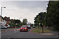
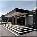
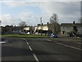
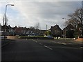
Residents of B26 3SF have access to a range of amenities within practical reach. The retail sector includes Iceland Sheldon, M&S Sheldon, and Morrisons Sheldon, providing everyday shopping needs. Nearby rail stations such as Marston Green, Olton, and Acocks Green offer connections to Birmingham’s transport network, while proximity to Birmingham International Airport and Corporation Street enhances mobility. The area’s historical character is complemented by St Giles Church, a 14th-century landmark with 12th-century features. While the data does not mention parks or leisure facilities, the presence of multiple rail and metro links suggests opportunities for recreation beyond the immediate area. The combination of retail, transport, and historical sites creates a lifestyle that balances convenience with a touch of local heritage, though the small size of the area means residents may need to travel further for more extensive amenities.
Amenities
Schools
The nearest school to B26 3SF is St Thomas More Catholic Primary School, which serves the area’s primary education needs. The school has an Ofsted rating of ‘good’, indicating a satisfactory standard of teaching and facilities. As a primary school, it caters to children aged 4–11, making it a key consideration for families with young children. The absence of secondary schools or other educational institutions in the data means the area relies on this single primary school for early education. While the ‘good’ rating suggests a reliable educational environment, parents may need to look beyond the immediate area for secondary schooling. The presence of a single school with a solid rating could be a positive for families prioritising a stable, local education system.
| Rank | School | Type | Entry gender | Ages |
|---|
Explore more schools in this area
Go to Schools tabDemographics
The community in B26 3SF is predominantly composed of adults aged 30–64, with a median age of 47. This suggests a mature population, likely with established careers and families. Home ownership is high at 57%, indicating a strong presence of long-term residents. The accommodation type is primarily houses, reflecting a suburban layout rather than high-density housing. The predominant ethnic group is White, though no specific diversity statistics are provided. The age profile implies a community focused on stability, with fewer young families or retirees compared to other areas. The absence of data on deprivation or income levels means the quality of life can only be inferred from available metrics, such as the high broadband score. However, the high crime risk—rated critical with a score of 13/100—suggests residents may need to consider safety measures. Overall, the area appears to cater to those prioritising homeownership and a settled lifestyle.
Household Size
Accommodation Type
Tenure
Ethnic Group
Religion
Household Composition
Age
Household Deprivation
NS-SEC
Explore more demographic insights in this area
Go to Demographics tabPlanning
Planning Constraints
- Flood RiskPremium
- Ramsar Wetland SitesPremium
- Area of Outstanding Natural BeautyPremium
- Protected Nature ReservePremium
- Protected WoodlandPremium