Area Overview for B26 3PL
Photos of B26 3PL


Area Information
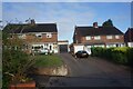
Living in B26 3PL means residing in a small, defined postcode area within east Birmingham’s suburban sprawl. With a population of 1,628, this cluster of homes sits near the border with Solihull, blending historical roots with modern convenience. The area’s name, Sheldon, traces back to the Domesday Book, where it was recorded as “Machitone.” Today, it retains a quiet, residential character, with homes predominantly in the form of houses rather than flats. Proximity to Birmingham International Airport and multiple railway stations, such as Olton and Acocks Green, ensures easy access to both regional and national transport networks. While the community is small, it is well-connected to nearby amenities, including retail hubs like Morrisons and M&S Sheldon. The area’s low flood risk and absence of protected natural sites suggest a stable, practical living environment. However, its compact size means residents must look beyond the immediate postcode for broader urban offerings, balancing seclusion with accessibility.
- Area Type
- Postcode
- Area Size
- Not available
- Population
- 1628
- Population Density
- 2602 people/km²
The property market in B26 3PL is characterised by a high rate of home ownership (76%), with houses forming the predominant accommodation type. This suggests a community focused on long-term residency rather than transient rental markets. The small population and limited area mean the housing stock is finite, likely centred on traditional suburban homes rather than modern developments. For buyers, this implies competition for available properties and a need to consider the area’s proximity to transport links, such as nearby railway stations and Birmingham International Airport. The lack of flats or high-density housing also means buyers seeking alternative property types may need to look further afield. The stability of ownership rates indicates a low turnover of properties, potentially offering security for those seeking a permanent home.
House Prices in B26 3PL
No properties found in this postcode.
Energy Efficiency in B26 3PL
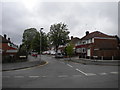
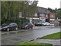
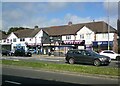
Daily life in B26 3PL is shaped by its proximity to retail and transport hubs. The area includes notable shops such as Morrisons Sheldon, M&S Sheldon, and Iceland Sheldon, offering convenience for grocery and general shopping. Nearby railway stations like Olton and Acocks Green provide easy access to Birmingham’s rail network, while proximity to Birmingham International Airport caters to those requiring frequent travel. The metro connectivity extends to Corporation Street, linking to urban centres. Although the area itself is small, these amenities contribute to a practical, commuter-friendly lifestyle. The presence of historic sites like St Giles Church, with its 14th-century architecture, adds a touch of local character. However, residents may need to venture beyond the postcode for more diverse leisure or cultural options.
Amenities
Schools
| Rank | School | Type | Entry gender | Ages |
|---|
Explore more schools in this area
Go to Schools tabDemographics
The population of B26 3PL is predominantly adults aged 30–64, with a median age of 47. This suggests a mature, settled community, likely with established careers and families. Home ownership is high at 76%, reflecting a preference for long-term residency over rental properties. The accommodation type is primarily houses, indicating a lack of high-density housing typical of urban centres. The predominant ethnic group is White, with no specific data on other demographics provided. This profile aligns with a suburban, middle-income area where stability and property investment are prioritised. The absence of detailed deprivation data means the area’s socioeconomic challenges cannot be assessed, but the high home ownership rate implies a relatively secure financial environment for residents.
Household Size
Accommodation Type
Tenure
Ethnic Group
Religion
Household Composition
Age
Household Deprivation
NS-SEC
Explore more demographic insights in this area
Go to Demographics tabPlanning
Planning Constraints
- Flood RiskPremium
- Ramsar Wetland SitesPremium
- Area of Outstanding Natural BeautyPremium
- Protected Nature ReservePremium
- Protected WoodlandPremium