Area Overview for B26 3AZ
Photos of B26 3AZ


Area Information
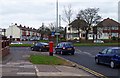
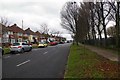
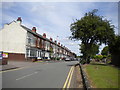
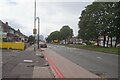
Living in B26 3AZ, a small residential cluster in east Birmingham, offers a blend of suburban tranquillity and proximity to urban amenities. The area, part of the Sheldon ward, sits near the border with Solihull, placing it within reach of both city and countryside. With a population of 1,900, it is a compact community defined by its historical roots. Sheldon’s name appears in the Domesday Book as ‘Machitone,’ and its St Giles Church, a 14th-century sandstone structure with medieval features, remains a local landmark. The area’s modest size means residents enjoy a tight-knit environment, where daily life is shaped by nearby retail, transport links, and historical architecture. While not a sprawling suburb, B26 3AZ benefits from its strategic location, with Birmingham International Airport and rail stations within practical reach. This postcode is ideal for those seeking a balance between suburban comfort and easy access to larger urban hubs, though its small scale means community dynamics are closely knit.
- Area Type
- Postcode
- Area Size
- Not available
- Population
- 1900
- Population Density
- 5509 people/km²
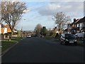
The property market in B26 3AZ is characterised by a strong emphasis on owner-occupied homes, with 66% of residents owning their properties. This suggests a community of long-term residents rather than a transient rental market. The accommodation type is predominantly houses, which are more common than flats in this area. This housing stock likely includes semi-detached and detached homes, typical of suburban settings. The small size of the postcode means the available properties are limited, and buyers may need to consider nearby areas for more options. The high home ownership rate also indicates a stable market, with fewer fluctuations compared to areas with higher rental activity. For buyers, this means a focus on established homes rather than new developments, though the limited supply could make the area competitive. The presence of houses also suggests a family-oriented environment, which may appeal to those seeking space and privacy.
House Prices in B26 3AZ
No properties found in this postcode.
Energy Efficiency in B26 3AZ
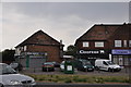
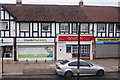
Residents of B26 3AZ have access to a range of amenities within walking or short driving distance. Retail options include Aldi Lyndon, Tesco Sheldon, and Iceland Sheldon, offering everyday shopping needs. The area’s rail stations—Acocks Green, Olton, and Lea Hall—provide regular connections to Birmingham and surrounding towns, while Birmingham International Airport is a major nearby hub. For leisure, the proximity to historical sites like St Giles Church adds cultural value. The mix of retail, transport, and historical landmarks creates a lifestyle that balances convenience with local character. The presence of multiple rail and metro options ensures residents can easily access city centres or regional destinations. This combination of practical amenities and historical context makes daily life in B26 3AZ both functional and rooted in the area’s heritage.
Amenities
Schools
| Rank | School | Type | Entry gender | Ages |
|---|
Explore more schools in this area
Go to Schools tabDemographics
The residents of B26 3AZ have a median age of 47, with the majority falling in the 30–64 age range. This suggests a community dominated by working-age adults, many of whom may be professionals or families. Home ownership is high at 66%, indicating a stable, long-term population. The area is predominantly composed of houses rather than flats, which aligns with the presence of traditional family homes. The predominant ethnic group is White, reflecting broader demographic patterns in the region. While no specific data on deprivation is provided, the high home ownership rate and age profile suggest a relatively stable economic environment. However, the absence of detailed diversity metrics means the community’s full composition remains less defined. The age range also implies a mix of established residents and those in their prime working years, potentially influencing local services and amenities.
Household Size
Accommodation Type
Tenure
Ethnic Group
Religion
Household Composition
Age
Household Deprivation
NS-SEC
Explore more demographic insights in this area
Go to Demographics tabPlanning
Planning Constraints
- Flood RiskPremium
- Ramsar Wetland SitesPremium
- Area of Outstanding Natural BeautyPremium
- Protected Nature ReservePremium
- Protected WoodlandPremium