Area Overview for B26 1SF
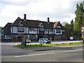
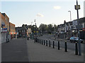
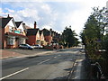
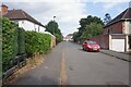
Photos of B26 1SF

Area Information
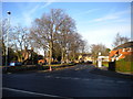
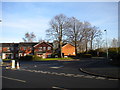
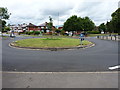
B26 1SF is a small residential cluster in east Birmingham, part of the Yardley East Ward. With a population of just 1,658, it retains a quiet, suburban character despite being within the city’s urban sprawl. Historically, Yardley has roots dating back over 1,000 years, from its 972 AD origins as Gyrdleah to its 1911 annexation into Birmingham. Today, it balances its heritage with modern living. The area is defined by its Victorian terraced houses and municipal estates, such as the Marlborough Farm and Fast Pits developments, which reflect its 1920s-1930s suburban expansion. Residents benefit from proximity to key transport links, including Lea Hall and Acocks Green railway stations, and Birmingham International Airport. Retail options like Iceland Yardley and Tesco Yardley cater to daily needs, while the surrounding area’s mix of historic sites—such as Old Yardley’s conservation area and Blakesley Hall—adds cultural depth. Living here offers a blend of tranquillity and accessibility, ideal for those seeking a settled lifestyle near Birmingham’s amenities.
- Area Type
- Postcode
- Area Size
- Not available
- Population
- 1658
- Population Density
- 6194 people/km²
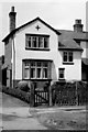
The property market in B26 1SF is dominated by owner-occupied homes, with 78% of properties in private hands. The accommodation type is predominantly houses, reflecting the area’s suburban character and historical development as a residential suburb. This contrasts with denser urban areas where flats are more common. The focus on houses suggests a market geared towards families and long-term residents, rather than short-term renters. Given the small population and limited land area, the housing stock is likely uniform, with limited scope for new developments. For buyers, this means a stable market with predictable demand, though competition for properties may be low due to the area’s modest size. Proximity to rail links and retail amenities adds to the appeal, making it a practical choice for those prioritising security and convenience over speculative growth.
House Prices in B26 1SF
No properties found in this postcode.
Energy Efficiency in B26 1SF
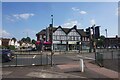
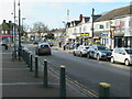
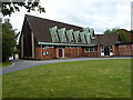
Living in B26 1SF offers a mix of practical amenities and historical charm. Within walking distance are retail outlets such as Iceland Yardley, Co-op Yardley, and Tesco Yardley, ensuring everyday needs are met. The area’s rail network, including Lea Hall and Acocks Green stations, provides easy access to Birmingham’s business districts and beyond. Proximity to Birmingham International Airport adds to its appeal for frequent travellers. The surrounding area also features historic sites like Old Yardley’s conservation area and Blakesley Hall, offering cultural and recreational opportunities. While the immediate vicinity lacks large parks, the area’s suburban layout fosters a sense of community, with local pubs like the Yew Tree serving as social hubs. This blend of convenience, heritage, and connectivity makes daily life in B26 1SF both practical and characterful.
Amenities
Schools
| Rank | School | Type | Entry gender | Ages |
|---|
Explore more schools in this area
Go to Schools tabDemographics
The community in B26 1SF is predominantly middle-aged, with a median age of 47 and the majority of residents falling within the 30-64 age range. Home ownership is high, at 78%, indicating a stable, long-term population. The area is characterised by houses rather than flats, reflecting its suburban layout. The predominant ethnic group is White, which aligns with broader trends in Birmingham’s outer districts. This demographic profile suggests a mature, family-oriented community with a focus on established living rather than transient rental markets. The absence of specific data on deprivation means the area’s quality of life can be inferred from its low crime risk and strong digital connectivity. With 78% of homes owned outright, residents likely prioritise long-term investment over short-term rental opportunities, shaping a cohesive, settled neighbourhood.
Household Size
Accommodation Type
Tenure
Ethnic Group
Religion
Household Composition
Age
Household Deprivation
NS-SEC
Explore more demographic insights in this area
Go to Demographics tabPlanning
Planning Constraints
- Flood RiskPremium
- Ramsar Wetland SitesPremium
- Area of Outstanding Natural BeautyPremium
- Protected Nature ReservePremium
- Protected WoodlandPremium