Area Overview for B26 1QE
Photos of B26 1QE


Area Information
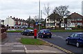
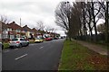
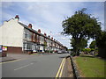
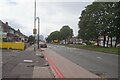
Living in B26 1QE means inhabiting a small, tightly knit residential cluster in east Birmingham, within easy reach of the city’s core. The area’s population of 1,352 reflects its compact nature, with homes predominantly in the form of houses rather than flats, suggesting a focus on family-oriented living. Nestled in the broader Yardley council constituency, it lies around 6 kilometres from Birmingham’s centre, offering a balance between suburban tranquillity and urban accessibility. Historically, the area was part of a larger ward encompassing Hay Mills and Tyseley, but its current boundaries reflect modern planning. You’ll find a mix of older housing stock and post-war developments, shaped by 20th-century infrastructure projects like the Swan underpass and Coventry Road widening. The postcode’s proximity to rail and metro links, including Acocks Green and Tyseley stations, ensures convenient travel to work or leisure. While the area lacks natural beauty designations, its low flood risk and proximity to retail and transport make it a practical choice for those seeking stability in a growing part of Birmingham.
- Area Type
- Postcode
- Area Size
- Not available
- Population
- 1352
- Population Density
- 7009 people/km²
The property market in B26 1QE is characterised by high home ownership (80%) and a predominance of houses, indicating a focus on owner-occupied, family-sized dwellings. This contrasts with areas where flats or rentals dominate, suggesting a different buyer profile—one prioritising space and long-term stability. The lack of flats may limit options for first-time buyers or those seeking smaller properties, but it also means the area is less affected by rental market fluctuations. Given the postcode’s small size, the immediate surroundings likely share similar housing stock, reinforcing a consistent market. For buyers, this means a relatively predictable environment, though the limited scale of the area may restrict choice. The high home ownership rate also implies that properties here are often held by residents for extended periods, which can stabilise prices but may also reduce turnover. Those considering purchase should view the area as a long-term investment, given its focus on established households.
House Prices in B26 1QE
No properties found in this postcode.
Energy Efficiency in B26 1QE
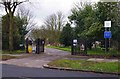
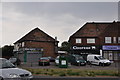
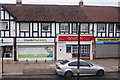
Living in B26 1QE grants access to a range of essential amenities within walking or short driving distance. Retail options include major supermarkets like Tesco, Iceland, and Co-op in Yardley, providing convenience for grocery shopping. The area’s rail network is robust, with stations such as Acocks Green, Tyseley, and Olton offering regular services to Birmingham’s city centre and beyond. Nearby, Birmingham International Airport and Corporation Street metro station further expand travel possibilities. While the data does not specify parks or leisure facilities, the area’s proximity to the city suggests access to larger green spaces and cultural venues. The presence of multiple transport links and retail hubs means daily life is efficient, with minimal need to travel far for essentials. The community’s character is shaped by its practicality—residents can meet most needs locally, though the area’s small size may mean it leans on surrounding districts for more specialised services.
Amenities
Schools
| Rank | School | Type | Entry gender | Ages |
|---|
Explore more schools in this area
Go to Schools tabDemographics
B26 1QE’s population of 1,352 is predominantly composed of adults aged 30–64, with a median age of 47. This suggests a community of established professionals and families, rather than students or retirees. Home ownership is high, at 80%, indicating a stable, long-term resident base. The area’s accommodation is largely houses, which aligns with the demographic profile of older, settled households. The predominant ethnic group is White, though the data does not specify further diversity metrics. With 80% of homes owned outright, the area is not heavily reliant on rentals, which may influence local dynamics and property values. The absence of detailed deprivation data means the area’s economic profile remains opaque, but the high home ownership rate suggests a relatively secure financial environment. For residents, this translates to a community where property is seen as an investment rather than a temporary arrangement, fostering a sense of permanence.
Household Size
Accommodation Type
Tenure
Ethnic Group
Religion
Household Composition
Age
Household Deprivation
NS-SEC
Explore more demographic insights in this area
Go to Demographics tabPlanning
Planning Constraints
- Flood RiskPremium
- Ramsar Wetland SitesPremium
- Area of Outstanding Natural BeautyPremium
- Protected Nature ReservePremium
- Protected WoodlandPremium