Area Overview for B25 8LE
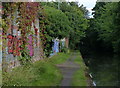
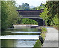
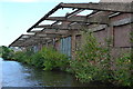
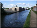
Photos of B25 8LE


Area Information
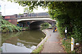
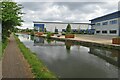
B25 8LE is a small residential postcode area in the east of Birmingham, England, encompassing parts of Tyseley and Hay Mills. With a population of nearly 2,000, it is a compact community defined by its historical roots and proximity to key transport routes. The area lies between Small Heath and South Yardley, bisected by the A45 Coventry Road, which links Birmingham to Coventry. Historically part of Worcestershire, it became part of Birmingham in 1911. The landscape is shaped by the River Cole and the Grand Union Canal, with the area’s modern identity tied to industrial heritage, including the former Webster Horsfall wire-drawing mill. Today, B25 8LE balances residential living with pockets of innovation, such as Tyseley Energy Park, which anchors the Tyseley Environmental Enterprise District. Residents benefit from proximity to rail and metro networks, while the area’s compact size fosters a sense of locality. Living here means navigating a mix of older housing stock and emerging green initiatives, with daily life influenced by the surrounding urban infrastructure and historical landmarks like Hay Hall.
- Area Type
- Postcode
- Area Size
- Not available
- Population
- 1999
- Population Density
- 5065 people/km²
The property market in B25 8LE is characterised by a 58% home ownership rate, indicating that nearly six in ten properties are owner-occupied. This contrasts with the broader Birmingham trend, where rental demand often outpaces supply. The area’s housing stock is predominantly composed of houses, a rarity in urban settings, suggesting a mix of older, perhaps larger properties. Given the small size of the postcode and its residential focus, the housing supply is likely limited, making the market competitive for buyers. The presence of houses may appeal to those seeking more space or a traditional property type, though this could also mean fewer modern developments. For prospective buyers, the area’s compact nature means that properties are likely to be closely located to amenities and transport links. However, the lack of specific data on property prices or recent sales trends means the market’s dynamics—such as whether it is buyer or renter-driven—remain unclear. The dominance of owner-occupied homes may also reflect long-term residency, with fewer short-term rental properties influencing the local landscape.
House Prices in B25 8LE
No properties found in this postcode.
Energy Efficiency in B25 8LE
The lifestyle in B25 8LE is shaped by its proximity to retail, rail, and metro services. Within practical reach are shops such as Lidl, Farmfoods, and Tesco in Yardley, providing everyday convenience for residents. The area’s rail network includes Tyseley, Acocks Green, and Spring Road stations, while metro stops like Corporation Street and Grand Central New Street offer links to Birmingham’s broader transport system. These connections make commuting or accessing city amenities straightforward. Historically, the area was a hub for industries like wire drawing and manufacturing, but today, it balances this legacy with modern living. The presence of Tyseley Energy Park and the Tyseley Environmental Enterprise District hints at a forward-thinking community focused on innovation. While parks and green spaces are not explicitly detailed in the data, the area’s boundaries include the Grand Union Canal, offering potential for leisurely walks or recreational activities. The mix of retail, transport, and historical sites creates a lifestyle that blends practicality with a sense of place, catering to both daily needs and a connection to the area’s industrial past.
Amenities
Schools
| Rank | School | Type | Entry gender | Ages |
|---|
Explore more schools in this area
Go to Schools tabDemographics
B25 8LE has a median age of 47, with the majority of residents falling within the 30-64 age range. This suggests a community of established adults, many of whom may be in their prime working years or nearing retirement. Home ownership stands at 58%, indicating a moderate balance between owner-occupied and rental properties. The predominant accommodation type is houses, which is unusual in a city like Birmingham, where flats are more common. The area’s demographic profile is further defined by its ethnic composition, with the Asian community forming the largest group. This diversity contributes to the area’s cultural character. While no deprivation data is provided, the presence of 58% home ownership and a median age suggesting stability implies a community with mixed economic profiles. The lack of specific deprivation metrics means the area’s quality of life cannot be fully assessed in this context, but the demographic structure points to a settled, middle-aged population with established ties to the local area.
Household Size
Accommodation Type
Tenure
Ethnic Group
Religion
Household Composition
Age
Household Deprivation
NS-SEC
Explore more demographic insights in this area
Go to Demographics tabPlanning
Planning Constraints
- Flood RiskPremium
- Ramsar Wetland SitesPremium
- Area of Outstanding Natural BeautyPremium
- Protected Nature ReservePremium
- Protected WoodlandPremium