Area Overview for B24 9LZ
Photos of B24 9LZ
Area Information
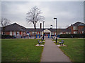
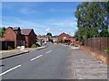
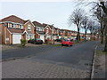
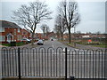
B24 9LZ is a small residential postcode area in England, encompassing a compact cluster of homes in the Erdington district of Birmingham. With a population of 1,738, it reflects the character of a mature suburb, shaped by its historical roots as a village near the River Tame. The area’s development as a Birmingham suburb in the Victorian era is evident in its layout, with Erdington High Street serving as a key retail hub. Today, B24 9LZ offers a quiet, community-focused environment, where homes are predominantly owner-occupied and the median age of residents is 47, indicating a stable, middle-aged demographic. The area’s proximity to historical sites like Rookery Park and the former Sir Josiah Mason Orphanage adds a layer of local heritage. While it is not a sprawling urban zone, its small size means residents are close to essential amenities, from local schools to rail connections. For those seeking a balance between suburban comfort and city accessibility, B24 9LZ provides a snapshot of traditional Birmingham living, with a distinct sense of place rooted in its past.
- Area Type
- Postcode
- Area Size
- Not available
- Population
- 1738
- Population Density
- 3876 people/km²
The property market in B24 9LZ is defined by a high rate of home ownership (60%) and a predominance of houses as the accommodation type. This suggests a community where homeownership is the norm, likely attracting families seeking long-term stability. The presence of houses rather than flats or apartments indicates a focus on larger, more traditional properties, which may appeal to those prioritising space and privacy. Given the area’s small size, the housing stock is likely limited, making it a niche market for buyers seeking specific characteristics. The high home ownership rate also implies lower rental activity, which could mean fewer short-term tenants and a more consistent local economy. For prospective buyers, this environment offers the potential for investment in established properties, though the limited scale of the area may restrict options. The market’s character reflects a balance between suburban comfort and the practicalities of a compact postcode.
House Prices in B24 9LZ
Showing 6 properties
| Address | Type | Beds | Baths | Last Sale Price | Last Sale Date | |
|---|---|---|---|---|---|---|
| Apartment 1, 35 Nocks Avenue, Birmingham, B24 9LZ | Flat | - | - | - | - | |
| Apartment 4, 35 Nocks Avenue, Birmingham, B24 9LZ | Flat | - | - | - | - | |
| Apartment 5, 35 Nocks Avenue, Birmingham, B24 9LZ | Flat | - | - | - | - | |
| Apartment 3, 35 Nocks Avenue, Birmingham, B24 9LZ | Flat | - | - | - | - | |
| Apartment 6, 35 Nocks Avenue, Birmingham, B24 9LZ | Flat | - | - | - | - | |
| Apartment 2, 35 Nocks Avenue, Birmingham, B24 9LZ | Flat | - | - | - | - |
Energy Efficiency in B24 9LZ
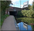
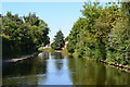
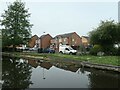
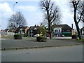
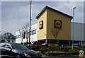
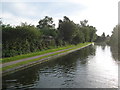
The lifestyle in B24 9LZ is enriched by nearby amenities that cater to daily needs and leisure. Retail options include Lidl Tyburn, Co-op High, and Heron Erdington, providing access to groceries and local services. The area’s historical retail heart, Erdington High Street, remains a focal point for shopping and community activity. Parks and open spaces such as Rookery Park, Brookvale Park Lake, and the former Highcroft Hospital site offer recreational opportunities, from walking to relaxation. The nearby Birmingham Fazeley Canal and Salford Bridge add to the area’s charm, blending natural and historical elements. For families, the proximity to schools and the availability of parks create a balanced environment. The presence of notable sites like St Barnabas Church and Goodison Gardens adds cultural depth. While the data does not specify dining options, the mix of retail and green spaces suggests a community-oriented lifestyle where convenience and tranquillity coexist.
Amenities
Schools
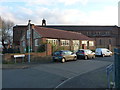
B24 9LZ is served by several schools, including Paget Primary School and St Peter and St Paul RC Junior and Infant School, which operates as both a primary and academy. These institutions cater to younger families, providing a range of educational options. The presence of two primary schools within the area suggests a well-established network for early education, though the data does not specify Ofsted ratings or academic performance. The duplication of St Peter and St Paul RC Junior and Infant School in the data may reflect administrative detail rather than separate entities. For families, the availability of local schools reduces the need for long commutes, reinforcing the area’s appeal as a residential choice. However, the absence of secondary schools in the data means that parents may need to consider nearby options for older children. The mix of primary and academy schools indicates a blend of traditional and possibly more specialised educational approaches.
| Rank | School | Type | Entry gender | Ages |
|---|
Explore more schools in this area
Go to Schools tabDemographics
The population of B24 9LZ is 1,738, with a median age of 47, placing it firmly in the adult demographic bracket (30–64 years). This suggests a community of established residents, many of whom may be in their prime working years or nearing retirement. Home ownership is strong, with 60% of properties occupied by their owners, indicating a degree of stability and long-term residency. The accommodation type is predominantly houses, which aligns with the area’s suburban character and suggests a preference for family-friendly living. The predominant ethnic group is White, though the data does not specify the proportion of other groups. The age profile and ownership figures imply a low turnover of residents, fostering a sense of continuity. However, the lack of detailed diversity data means the full range of community experiences remains unexplored. For those considering B24 9LZ, the demographic profile signals a mature, settled population with a focus on residential permanence.
Household Size
Accommodation Type
Tenure
Ethnic Group
Religion
Household Composition
Age
Household Deprivation
NS-SEC
Explore more demographic insights in this area
Go to Demographics tabPlanning
Planning Constraints
- Flood RiskPremium
- Ramsar Wetland SitesPremium
- Area of Outstanding Natural BeautyPremium
- Protected Nature ReservePremium
- Protected WoodlandPremium