Area Overview for B23 6RT
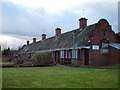
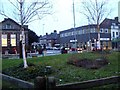
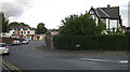
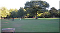
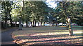
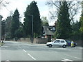
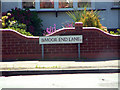
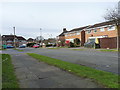
Photos of B23 6RT
Area Information
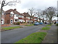
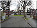
Living in B23 6RT means inhabiting a small, defined residential cluster in the heart of Erdington, Birmingham. With a population of 1,820, this area is compact yet historically rich, shaped by its origins as a village near the River Tame and its evolution into a suburban hub. The district’s character is anchored in Erdington High Street, a major retail corridor, and landmarks like Rookery Park, once the administrative heart of the local district. Residents benefit from proximity to Birmingham’s infrastructure, with rail and metro links offering connectivity to the city. The area’s demographics reflect a mature community, with a median age of 47 and a strong presence of adults aged 30–64. While the population is small, the area’s historical significance and modern amenities create a balance between tradition and convenience. For those seeking a quiet yet accessible suburban life, B23 6RT offers a blend of local identity and practicality, with no major planning constraints or environmental risks. However, the high crime risk noted in assessments is a factor to consider for prospective buyers.
- Area Type
- Postcode
- Area Size
- Not available
- Population
- 1820
- Population Density
- 4444 people/km²
The property market in B23 6RT is defined by its low home ownership rate—just 25% of residents own their homes—which suggests a rental-dominated market. The accommodation type is primarily houses, which is notable for a small postcode area, implying a focus on family homes or detached properties. This mix may attract buyers seeking larger living spaces, though the limited number of owner-occupied properties could indicate a lack of long-term investment in the area. The small size of the postcode means the housing stock is likely concentrated within a tight radius, potentially limiting availability for buyers. For those considering the area, the predominance of houses may offer practicality for growing families, but the low home ownership rate could signal a transient population or limited developer activity. Prospective buyers should also consider the broader context of Birmingham’s property trends, as B23 6RT is part of a larger suburban landscape with varying market dynamics.
House Prices in B23 6RT
No properties found in this postcode.
Energy Efficiency in B23 6RT
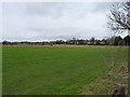
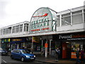
Residents of B23 6RT have access to a range of amenities within practical reach. The nearby retail options include Co-op High, Heron Erdington, and Lidl BIR Erdington 2, providing everyday shopping convenience. Public transport links are strong, with rail and metro stations facilitating easy access to Birmingham’s city centre and beyond. Green spaces such as Rookery Park and Brookvale Park Lake offer recreational opportunities, while historical sites like Erdington High Street and the former Sir Josiah Mason Orphanage site add cultural value. The area’s mix of retail, transport, and open spaces supports a balanced lifestyle, blending suburban tranquillity with urban accessibility. For families, the presence of schools and parks creates an environment conducive to both daily living and long-term settlement. However, the lack of specific details on dining or leisure venues means further local exploration may be necessary to fully assess the area’s offerings.
Amenities
Schools
Residents of B23 6RT have access to a range of educational institutions, including Osborne Nursery School and Osborne Primary School, which holds a ‘good’ Ofsted rating. For independent education, Highclare School and Imedia School—rated ‘outstanding’ by Ofsted—are nearby, offering alternatives for families seeking private schooling. The presence of both state and independent schools provides flexibility, though the data does not specify catchment areas or student numbers. The ‘outstanding’ rating at Imedia School highlights a high standard of education, which could be a draw for families prioritising academic excellence. However, the lack of detailed performance metrics for other schools means potential buyers should investigate further. The mix of school types reflects Erdington’s role as a suburban area with diverse educational options, though the overall quality of schools remains a key consideration for families.
| Rank | School | Type | Entry gender | Ages |
|---|
Explore more schools in this area
Go to Schools tabDemographics
The community in B23 6RT is predominantly composed of adults aged 30–64, with a median age of 47. This suggests a settled population, likely with established careers and family ties to the area. Home ownership is relatively low at 25%, indicating that a significant portion of residents may be renters or in shared ownership arrangements. The accommodation type is primarily houses, which is unusual for a small postcode area, suggesting a mix of family homes and detached properties. The predominant ethnic group is White, though no specific data on diversity or deprivation levels is provided. The age profile implies a community focused on stability, with fewer young families or retirees compared to other areas. The lack of detailed diversity metrics means the area’s social composition remains largely unexplored in the data. For buyers, the low home ownership rate may reflect limited long-term investment in property, though the presence of houses could appeal to those seeking space.
Household Size
Accommodation Type
Tenure
Ethnic Group
Religion
Household Composition
Age
Household Deprivation
NS-SEC
Explore more demographic insights in this area
Go to Demographics tabPlanning
Planning Constraints
- Flood RiskPremium
- Ramsar Wetland SitesPremium
- Area of Outstanding Natural BeautyPremium
- Protected Nature ReservePremium
- Protected WoodlandPremium