Area Overview for B23 6RJ
Photos of B23 6RJ
Area Information
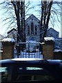
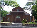
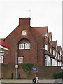
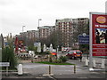
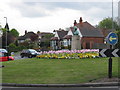
Living in B23 6RJ means being part of a small, tightly knit residential cluster in Erdington, a historic suburb of Birmingham. With a population of 1,820, the area retains a village-like character despite its proximity to the city. Centred around Erdington High Street, the district features a third of Birmingham’s retail space, blending traditional charm with modern convenience. The area’s origins trace back to the 9th century, with roots along the River Tame and Roman roads. Today, it offers a mix of historic sites, such as St Barnabas Church and Rookery Park, alongside newer developments like Sorrel House. Residents benefit from proximity to Birmingham’s transport networks, including rail and metro links, while the low flood risk and absence of protected natural areas suggest a practical, low-constraint environment. The community, skewed toward adults aged 30–64, reflects a mature demographic, with a focus on stability and accessibility.
- Area Type
- Postcode
- Area Size
- Not available
- Population
- 1820
- Population Density
- 4444 people/km²
B23 6RJ’s property market is characterised by a 25% home ownership rate, suggesting a rental-heavy market. The accommodation type is primarily houses, which are more common than flats in this suburban setting. This reflects Erdington’s historical development as a residential suburb with larger homes. For buyers, the small area and limited housing stock mean competition may be fierce, particularly for properties near key amenities like Erdington High Street. The lower home ownership rate also implies a transient population, which could affect property values and long-term investment potential. Those seeking owner-occupied homes may need to look beyond the immediate postcode to nearby suburbs.
House Prices in B23 6RJ
No properties found in this postcode.
Energy Efficiency in B23 6RJ
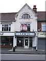
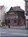
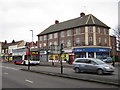
The lifestyle in B23 6RJ is shaped by its proximity to Erdington High Street, a major retail hub with shops like Heron Erdington. Residents can access five retail outlets within practical reach, complemented by rail and metro stations that connect to Birmingham’s urban core. Parks such as Rookery Park and Brookvale Park Lake offer green spaces for leisure, while historical sites like the former Sir Josiah Mason Orphanage add cultural depth. The area’s mix of shopping, transport, and recreational facilities supports a balanced daily life, blending suburban tranquillity with urban accessibility.
Amenities
Schools
B23 6RJ is served by a range of schools, including Osborne Nursery School and Osborne Primary School, both offering early years and primary education. Osborne Primary School holds a ‘good’ Ofsted rating, while Imedia School, an independent institution, is rated ‘outstanding’. Highclare School, another independent option, provides alternative educational pathways. The mix of state and independent schools caters to diverse preferences, from local community-focused education to private alternatives. Families seeking high academic standards may prioritise Imedia School, while those valuing affordability and proximity might opt for the state-run options. The presence of multiple schools within walking distance enhances the area’s appeal for households with children.
| Rank | School | Type | Entry gender | Ages |
|---|
Explore more schools in this area
Go to Schools tabDemographics
The population of B23 6RJ is 1,820, with a median age of 47, indicating a community dominated by middle-aged adults. Over 75% of residents fall within the 30–64 age range, suggesting a focus on family life and established careers. Home ownership is relatively low at 25%, implying a higher proportion of renters, which may reflect the area’s history as a suburban extension of Birmingham. The predominant accommodation type is houses, aligning with the suburban character of Erdington. The predominant ethnic group is White, though specific diversity metrics are not detailed. This demographic profile shapes a community prioritising stability and proximity to amenities, with fewer young families compared to other urban areas.
Household Size
Accommodation Type
Tenure
Ethnic Group
Religion
Household Composition
Age
Household Deprivation
NS-SEC
Explore more demographic insights in this area
Go to Demographics tabPlanning
Planning Constraints
- Flood RiskPremium
- Ramsar Wetland SitesPremium
- Area of Outstanding Natural BeautyPremium
- Protected Nature ReservePremium
- Protected WoodlandPremium