Area Overview for B21 9BD
Photos of B21 9BD


Area Information
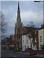
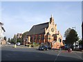
Handsworth Ward sits approximately two kilometres north of Birmingham City Centre, functioning as a distinct residential cluster within the larger West Midlands conurbation. This specific postcode area, B21 9BD, comprises a small population of 1,809 residents living in a tight-knit neighbourhood environment. The location retains deep historical roots, transitioning from a Saxon farm estate recorded in the Domesday Survey to an industrial hub driven by Matthew Boulton and James Watt during the Industrial Revolution. You will find a community shaped by this layered history, where ancient landmarks like St Mary's Church coexist with the legacy of Soho House. Living in this part of Handsworth means being close to the historic edge of the city while retaining a suburban feel. The area was formally incorporated into Birmingham in 1911, ending its status as a separate urban district, yet it maintains a unique character separate from the immediate city core. The ward's evolution from scattered farmland to a dense urban residential zone reflects broader changes across the metropolis. You are looking at a place where the past is physically preserved through notable features like Handsworth Park, originally named Victoria Park and opened in 1890. This specific cluster offers a grounded living experience away from the bustle of the central business district, providing a安静(quiet) alternative just minutes from major transport arteries and the Jewellery Quarter Railway Station.
- Area Type
- Postcode
- Area Size
- Not available
- Population
- 1809
- Population Density
- 11747 people/km²
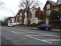
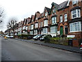
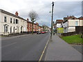
The housing stock in B21 9BD is defined by a predominance of houses, setting it apart from areas where flats or social housing dominate. With 46% of residents owning their homes, the area presents a mixed market where private buyers and investors sit alongside landlords and tenants. This ownership rate is lower than the national average, suggesting that a large proportion of the workforce may rely on local employment or face barriers to full home ownership. For you, a prospective buyer, this dynamic means you are entering a market where demand comes from both those seeking stability in established properties and those renting within a growing urban zone. Given the small population of 1,809, the stock is relatively limited compared to wider wards that stretch over thousands of homes. The presence of houses implies a more traditional street layout and garden access, typical of the suburban development that grew as Birmingham expanded post-1911. You will not find the vast landscape of estates common in new-build developments; instead, there is a collection of residential units that have evolved alongside the city. The high concentration of house ownership among the minority suggests that when properties become available, they often generate interest from those valuing the specific location within Handsworth. This area represents a chance to secure a property in a ward with a distinct identity, situated just kilometres from the city centre but insulated by its historical boundaries.
House Prices in B21 9BD
No properties found in this postcode.
Energy Efficiency in B21 9BD
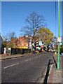
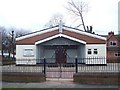
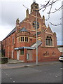
Daily life for residents of B21 9BD is supported by a practical array of amenities within short reach. For your weekly shopping, Iceland Handsworth, Lidl Handsworth, and Farmfoods Handsworth offer extensive grocery ranges, ensuring you do not need to travel far for essentials. The local transport network is equally dense, with the Metro lines at Soho Benson Road, Winson Green Outer Circle, and Handsworth Booth Street providing frequent stops. If you prefer trains, Jewellery Quarter Railway Station, Perry Barr Railway Station, and Hawthorns Railway Station are all accessible. Beyond retail and transit, the area is anchored by significant public spaces. Handsworth Park, formerly Victoria Park, serves as the principal landmark for the neighbourhood. Designed in the late 19th century and opened for Queen Victoria's Golden Jubilee, it offers rolling green spaces, a bowling green, and a cricket ground for your leisure. The park also hosted major events like the Birmingham Flower Show in its earlier years. St Mary's Church, dating from the 13th century, stands as a historic focal point near the centre of the ancient parish. While some grander historic buildings like Heathfield Hall have been lost, the surviving features provide a rich environment for walking and quiet contemplation. You can enjoy a weekend stroll through the park or pop into one of the nearby supermarkets, balancing convenience with a touch of historical charm.
Amenities
Schools
| Rank | School | Type | Entry gender | Ages |
|---|
Explore more schools in this area
Go to Schools tabDemographics
The community profile for B21 9BD reveals a mature and stable population, with a median age of 47 years. Most residents fall into the broad age range of 30 to 64 years, indicating that families and established professionals dominate the demographic landscape. Home ownership stands at 46%, meaning fewer than half of the households own their property outright. This suggests a significant portion of the local population rents their accommodation, which often reflects the transitional history of the ward from industrial worker housing to modern urban living. The predominant ethnic group is Asian, contributing to a diverse and culturally varied neighbourhood. This demographic mix reflects the area's complex history, particularly the post-war arrival of West Indian workers and subsequent immigration waves that transformed Handsworth into a centre for the Afro-Caribbean community before seeing significant Asian population growth in later decades. The accommodation type is primarily houses, distinguishing this small cluster from areas dominated by high-rise blocks or social tenements found elsewhere in the city. Living here means sharing a space with neighbours who have likely settled down for the long term, enjoying a stability that correlates with the older age profile and strong presence of established families. The statistical picture points to a residential zone rather than a transient commuter hub.
Household Size
Accommodation Type
Tenure
Ethnic Group
Religion
Household Composition
Age
Household Deprivation
NS-SEC
Explore more demographic insights in this area
Go to Demographics tabPlanning
Planning Constraints
- Flood RiskPremium
- Ramsar Wetland SitesPremium
- Area of Outstanding Natural BeautyPremium
- Protected Nature ReservePremium
- Protected WoodlandPremium