Area Overview for B21 8EH
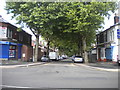
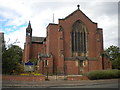
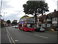
Photos of B21 8EH

Area Information
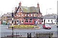
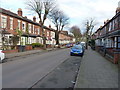
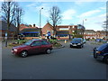
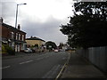
Living in B21 8EH means being part of a small, tightly knit residential cluster in the heart of Birmingham. With a population of 1,473, the area is compact but offers a blend of historical and modern living. Situated in the Holyhead ward, it is part of Birmingham’s industrial legacy, with roads like Holyhead Road tracing their origins to 18th-century turnpikes. The area’s character is defined by Victorian architecture, such as the New Inns public house, alongside contemporary housing conversions. Daily life here is shaped by proximity to transport networks, including tram lines and rail stations, and a mix of retail and community spaces. While the ward has a younger demographic than the city as a whole, B21 8EH’s residents are predominantly adults aged 30–64, reflecting a mature, stable community. The area’s compact size means amenities are within easy reach, from local shops to schools, making it practical for families and commuters. However, its inner-city location also means it is part of Birmingham’s dynamic but sometimes challenging urban environment.
- Area Type
- Postcode
- Area Size
- Not available
- Population
- 1473
- Population Density
- 5141 people/km²
The property market in B21 8EH is characterised by a 36% home ownership rate, with houses making up the majority of accommodation types. This suggests that while owner-occupation is present, the area is not dominated by private homeownership, which may indicate a stronger rental market. The prevalence of houses, rather than flats or apartments, could appeal to buyers seeking more space or those prioritising family-friendly layouts. However, the small population and compact nature of the postcode suggest limited housing stock, which may restrict availability for buyers. The low home ownership rate could also imply higher demand for rental properties, potentially driving up competition for available homes. For buyers, this means that securing a property here may require careful consideration of local demand and the balance between owner-occupied and rental properties. The presence of houses may also mean that properties are larger than average, which could be a factor for those seeking specific living conditions.
House Prices in B21 8EH
No properties found in this postcode.
Energy Efficiency in B21 8EH
Life in B21 8EH is shaped by its proximity to a range of practical amenities. Residents have access to five retail outlets, including major supermarkets like Tesco Handsworth and Lidl Handsworth, ensuring daily shopping needs are met locally. The area’s five metro stops, such as Handsworth Booth Street and Winson Green Outer Circle, provide easy access to public transport, while three rail stations—Hawthorns, Hamstead, and Perry Barr—connect the area to Birmingham’s broader network. This infrastructure supports both commuting and leisure travel. The character of the area includes historical features like the New Inns public house, which has stood since the 18th century, adding a sense of continuity to the urban landscape. While parks or green spaces are not explicitly mentioned, the nearby transport links and retail options suggest a lifestyle focused on convenience and accessibility. The mix of modern and historic elements, combined with practical amenities, makes daily life in B21 8EH functional and connected.
Amenities
Schools
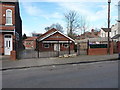
The nearest school to B21 8EH is St Augustine’s Catholic Primary School, which serves the area with a primary education offering. The school holds a ‘Good’ Ofsted rating, indicating a satisfactory standard of teaching and student outcomes. As a primary school, it caters to the needs of younger children, making it a key consideration for families with young dependents. The absence of secondary schools in the immediate vicinity suggests that students may need to travel to nearby areas for further education, though specific details on nearby secondary institutions are not provided. The presence of a single primary school with a positive rating implies that families may have limited options for primary education, but the quality of the existing school could mitigate concerns about availability. For prospective homebuyers, the school’s rating and proximity are important factors in assessing the area’s suitability for raising children.
| Rank | School | Type | Entry gender | Ages |
|---|
Explore more schools in this area
Go to Schools tabDemographics
The community in B21 8EH is predominantly composed of adults aged 30–64, with a median age of 47. This suggests a mature population, likely with established careers and families. Home ownership rates are relatively low at 36%, indicating that a significant portion of the housing stock is rented. The area’s accommodation is primarily houses, which may appeal to those seeking more space than typical flats. The predominant ethnic group is the Asian community, reflecting broader demographic trends in Birmingham. This diversity is likely to influence the cultural fabric of the area, though specific data on community cohesion or languages spoken is not provided. The low home ownership rate may indicate a rental market dominated by private landlords or social housing, which could affect property values and investment potential. The absence of specific deprivation data means it is unclear how economic factors influence quality of life, but the age profile suggests a population with stable employment and long-term residency.
Household Size
Accommodation Type
Tenure
Ethnic Group
Religion
Household Composition
Age
Household Deprivation
NS-SEC
Explore more demographic insights in this area
Go to Demographics tabPlanning
Planning Constraints
- Flood RiskPremium
- Ramsar Wetland SitesPremium
- Area of Outstanding Natural BeautyPremium
- Protected Nature ReservePremium
- Protected WoodlandPremium