Area Overview for B21 8BA
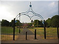
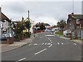
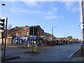
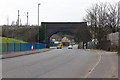
Photos of B21 8BA

Area Information
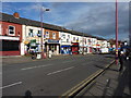
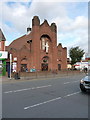
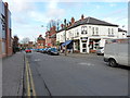
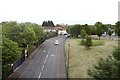
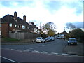
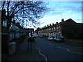
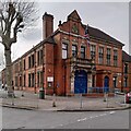
B21 8BA is a compact residential postcode in England, home to 2,066 people. Situated in a historically industrialised part of Birmingham, it reflects the city’s layered past, with Victorian architecture coexisting alongside modern housing conversions. The area’s character is shaped by its proximity to Holyhead Road, a key transport artery that once hosted trams. Residents benefit from a mix of practical amenities, including retail outlets like Farmfoods Handsworth and nearby railway stations. The community, predominantly Asian, leans towards older adults, with a median age of 47, though the area’s younger demographic profile contrasts with Birmingham’s broader trends. Daily life here balances convenience with a sense of rootedness, with local landmarks like the New Inns pub standing as quiet testaments to the area’s enduring history. While the population is small, the postcode’s strategic location near metro and rail networks makes it accessible for commuters, blending suburban comfort with urban connectivity.
- Area Type
- Postcode
- Area Size
- Not available
- Population
- 2066
- Population Density
- Not available
B21 8BA’s property market is defined by its 42% home ownership rate, indicating that less than half of residents own their homes. The accommodation type is predominantly houses, which is unusual in modern urban areas but aligns with the area’s historical development. This suggests a mix of older, possibly larger properties and newer conversions, such as the Victorian shop parades repurposed for contemporary living. The low home ownership rate implies a rental market that may dominate, though the small population size means the housing stock is limited. Buyers should consider the area’s compact nature, which may restrict availability of properties. The presence of houses rather than flats or apartments suggests a focus on family-friendly homes, though the lack of detailed data on property sizes or prices means potential buyers must investigate further. The area’s proximity to transport links may offset its smaller scale, appealing to those prioritising connectivity over expansive living spaces.
House Prices in B21 8BA
No properties found in this postcode.
Energy Efficiency in B21 8BA
Residents of B21 8BA have access to a range of practical amenities within easy reach. The area includes five retail outlets, such as Farmfoods Handsworth, Lidl, and Iceland, providing everyday shopping convenience. Nearby metro stations like Handsworth Booth Street and Winson Green Outer Circle facilitate quick travel to Birmingham’s commercial hubs. Rail services at Hawthorns and Smethwick stations connect to regional destinations. The character of the area is defined by its mix of historic and modern spaces, including Victorian shop parades and contemporary housing. While parks or green spaces are not explicitly mentioned, the proximity to the A5 and historical sites like the New Inns pub suggests a blend of urban and semi-rural elements. The presence of multiple transport options and retail outlets enhances the area’s appeal, offering a balance between convenience and a sense of community.
Amenities
Schools
Residents of B21 8BA have access to St James Church of England Primary School in Handsworth, which holds an Ofsted rating of “good.” This school serves the local community, offering primary education with a focus on faith-based values. Nearby is Hamilton School, a special school catering to students with specific educational needs. The combination of a primary school with a strong rating and a special school provides a range of educational options for families, though the absence of secondary schools may require students to travel to nearby areas. The proximity of these institutions to the postcode suggests that families can access essential education services without long commutes. However, the lack of data on school capacity or catchment areas means prospective residents should verify whether their children would be eligible for admission.
| Rank | School | Type | Entry gender | Ages |
|---|
Explore more schools in this area
Go to Schools tabDemographics
The population of B21 8BA is 2,066, with a median age of 47, reflecting a community skewed towards adults aged 30–64. Home ownership here is relatively low at 42%, suggesting a mix of renters and owner-occupiers. The predominant accommodation type is houses, though the exact distribution of household types is unspecified. The area’s demographic profile is marked by a high proportion of Asian residents, aligning with broader trends in Birmingham’s more diverse wards. This diversity influences the social fabric, with cultural influences likely evident in local businesses and community interactions. The age profile indicates a mature population, which may affect demand for services tailored to older adults, such as healthcare or leisure facilities. While no deprivation data is provided, the area’s proximity to schools and transport suggests a functional infrastructure catering to its residents’ needs.
Household Size
Accommodation Type
Tenure
Ethnic Group
Religion
Household Composition
Age
Household Deprivation
NS-SEC
Explore more demographic insights in this area
Go to Demographics tabPlanning
Planning Constraints
- Flood RiskPremium
- Ramsar Wetland SitesPremium
- Area of Outstanding Natural BeautyPremium
- Protected Nature ReservePremium
- Protected WoodlandPremium
- Crime RiskPremium