Area Overview for B21 0LB
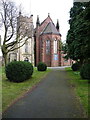
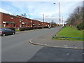
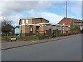
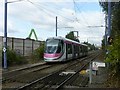
Photos of B21 0LB

Area Information
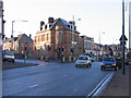
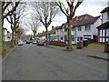
B21 0LB is a small residential postcode area nestled in the north-west of Birmingham, within the historically significant Holyhead ward. With a population of just 1,559, it reflects the compact, inner-city character of the region. The area’s demographic profile is distinct: it has a median age of 47, with a majority of residents aged 30–64, suggesting a community of established professionals and families. Its location along the A5, a historic route connecting London to Holyhead, underscores its role in Birmingham’s industrial past. The area blends Victorian architecture with modern conversions, as seen in landmarks like the New Inns public house, which has stood since the 18th century. Daily life here is shaped by proximity to transport networks, including trams that once ran along Holyhead Road, and a mix of retail and community hubs. While small, B21 0LB offers a snapshot of Birmingham’s evolving urban landscape, where historical roots meet contemporary living.
- Area Type
- Postcode
- Area Size
- Not available
- Population
- 1559
- Population Density
- 5657 people/km²
The property market in B21 0LB is characterised by a low home ownership rate of 33%, suggesting that the area is more rental-oriented than owner-occupied. The predominant accommodation type is houses, which may indicate a mix of older, traditional homes and converted properties. This aligns with the area’s historical development, where Victorian architecture coexists with modern adaptations. For buyers, the small size of the postcode area means that property choices are limited to a specific cluster of homes, likely concentrated around key amenities and transport links. The presence of rental properties may also mean competition for available homes, particularly for those seeking long-term ownership. Given the lack of specific data on property prices or trends, buyers should consider the area’s proximity to schools, transport, and retail as key factors in their decision-making.
House Prices in B21 0LB
No properties found in this postcode.
Energy Efficiency in B21 0LB
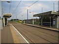
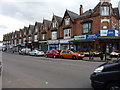
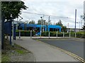
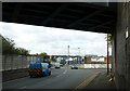
Daily life in B21 0LB is supported by a range of nearby amenities, including retail outlets such as Farmfoods Handsworth, Lidl Handsworth, and Iceland Handsworth. These stores provide essential shopping options for residents. The area’s transport links, including metro stops like Handsworth Booth Street and rail stations such as Smethwick Galton Bridge High Level, facilitate easy access to Birmingham’s broader urban and suburban networks. While the data does not specify parks or leisure facilities, the presence of multiple retail and transport hubs suggests a convenient, urban lifestyle. The mix of historical and modern amenities, combined with proximity to schools and transport, creates a practical environment for families and professionals seeking accessibility over expansive green spaces.
Amenities
Schools
The nearest schools to B21 0LB include Holyhead School, which operates as both a primary school and an academy. The academy received an Ofsted rating of ‘good’ as of February 2020, reflecting its performance in education. The presence of a primary school suggests that the area caters to families with younger children, while the academy may offer more advanced educational opportunities. The dual role of Holyhead School indicates a continuity of education from early years through to secondary levels, which is beneficial for families seeking a cohesive schooling environment. However, the data does not provide information on other nearby schools or their ratings, so families should verify additional options if needed.
| Rank | School | Type | Entry gender | Ages |
|---|
Explore more schools in this area
Go to Schools tabDemographics
The community in B21 0LB is predominantly composed of adults aged 30–64, with a median age of 47. This suggests a mature population, likely centered around families and professionals. Home ownership in the area is relatively low at 33%, indicating that a significant portion of residents live in rental properties. The accommodation type is primarily houses, which may reflect the area’s older, more established housing stock. The predominant ethnic group is Asian, aligning with broader trends in Birmingham’s diverse population. This demographic profile implies a community with strong cultural ties and potentially higher levels of intergenerational living. The lower home ownership rate may also point to a rental market that caters to transient or younger households, though the specific economic implications for residents are not detailed in the data.
Household Size
Accommodation Type
Tenure
Ethnic Group
Religion
Household Composition
Age
Household Deprivation
NS-SEC
Explore more demographic insights in this area
Go to Demographics tabPlanning
Planning Constraints
- Flood RiskPremium
- Ramsar Wetland SitesPremium
- Area of Outstanding Natural BeautyPremium
- Protected Nature ReservePremium
- Protected WoodlandPremium