Area Overview for B21 0DX
Photos of B21 0DX


Area Information
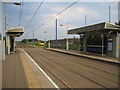
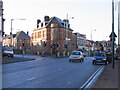
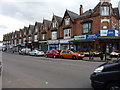
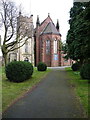
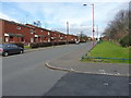
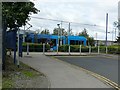
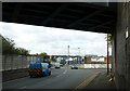
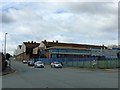
Living in B21 0DX means being part of a tightly knit residential cluster in England’s West Midlands, with a population of 1,665. This small area is characterised by its proximity to historical and modern infrastructure, including the A5 road, which once hosted trams. The community here reflects a blend of older and newer residents, with a median age of 47 and a significant proportion of adults aged 30–64. The area’s demographic profile is marked by a high representation of Asian communities, shaping its cultural and social fabric. Daily life is shaped by practical connectivity: five metro stops, five rail stations, and retail outlets like Farmfoods and Lidl provide convenience. While the area lacks large-scale amenities, its compact size ensures a sense of familiarity. Residents benefit from excellent broadband (score 99) and good mobile coverage (score 85), supporting both work and leisure. B21 0DX is a place where historical Victorian architecture meets modern living, offering a distinct urban experience within Birmingham’s broader context.
- Area Type
- Postcode
- Area Size
- Not available
- Population
- Not available
- Population Density
- Not available
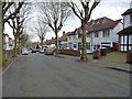
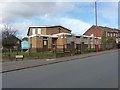
The property market in B21 0DX is defined by a 36% home ownership rate, which is below the national average, suggesting that most residents rent rather than own their homes. The area is characterised by houses rather than flats, indicating a focus on traditional family homes. This mix of ownership and rental properties creates a dynamic market, but the small size of the postcode means housing options are limited to the immediate vicinity. Buyers should consider that the area’s compact nature may restrict availability, and property values may reflect the local demand for single-family homes. For those seeking owner-occupied properties, the emphasis on houses could align with preferences for space and privacy, though the lower ownership rate may indicate challenges in securing mortgages or long-term investment opportunities.
House Prices in B21 0DX
No properties found in this postcode.
Energy Efficiency in B21 0DX
The lifestyle in B21 0DX is shaped by its proximity to essential amenities. Within walking distance are five retail outlets, including Farmfoods and Lidl, offering grocery and daily essentials. The area’s metro and rail links provide access to broader leisure opportunities, though specific parks or recreational spaces are not detailed in the data. The presence of multiple schools and transport hubs suggests a community-oriented environment, where families can balance domestic needs with urban connectivity. The mix of historical architecture and modern infrastructure adds character, while the compact size fosters a sense of familiarity. Residents benefit from a practical layout, with amenities clustered closely to reduce travel time. While the area lacks large-scale leisure facilities, its strategic location near Birmingham’s transport arteries ensures access to cultural and commercial hubs beyond its immediate boundaries.
Amenities
Schools
Residents of B21 0DX have access to several educational institutions, including Wattville Junior School, Wattville Infant and Nursery School, Wattville Primary School, Oasis Academy Wattville, and the independent Handsworth Alternative School. These range from primary education to academy provision, offering a mix of state and independent options. The presence of multiple primary schools suggests strong local provision for younger children, while the academy and independent school provide alternative pathways for older students. Families seeking a variety of educational environments can choose between traditional state schools and more specialised institutions. However, no Ofsted ratings are provided for these schools, so prospective parents may need to conduct further research into their performance. The diversity of school types reflects the area’s broader educational landscape, catering to different needs and preferences.
| Rank | School | Type | Entry gender | Ages |
|---|
Explore more schools in this area
Go to Schools tabDemographics
B21 0DX has a median age of 47, with the largest age group being adults aged 30–64. This suggests a community of established professionals and families, rather than students or retirees. Home ownership is relatively low at 36%, indicating that a majority of residents rent their homes. The area is predominantly composed of houses, not flats, which may appeal to those seeking more space. The predominant ethnic group is Asian, reflecting the broader demographic trends of Birmingham. While specific deprivation data is not provided, the lower home ownership rate could imply economic diversity, with a mix of long-term residents and newer arrivals. The age profile and housing stock suggest a stable, middle-aged population with a focus on family-oriented living, though the limited data means broader socioeconomic factors remain unclear.
Household Size
Accommodation Type
Tenure
Ethnic Group
Religion
Household Composition
Age
Household Deprivation
NS-SEC
Explore more demographic insights in this area
Go to Demographics tabPlanning
Planning Constraints
- Flood RiskPremium
- Ramsar Wetland SitesPremium
- Area of Outstanding Natural BeautyPremium
- Protected Nature ReservePremium
- Protected WoodlandPremium