Area Overview for B21 0BL
Photos of B21 0BL

Area Information
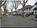
B21 0BL is a small residential postcode area in England, home to 1559 residents. It is a compact cluster of properties, likely centred on a specific localised community. The area’s demographic profile suggests a mature population, with a median age of 47 and the majority of residents aged between 30 and 64. This indicates a stable, established community, possibly with a strong presence of working-age adults. The area is predominantly composed of houses, reflecting a more traditional housing stock compared to high-density urban zones. While specific details about the area’s broader context are limited, the proximity to nearby amenities and transport links suggests it is integrated into a larger regional network. For homebuyers, the small size of the postcode means properties here are likely to be part of a tightly knit neighbourhood, offering a blend of residential tranquillity and access to essential services within walking or short driving distance. The area’s character is shaped by its demographics and infrastructure, making it a niche option for those seeking a quieter, community-focused living environment.
- Area Type
- Postcode
- Area Size
- Not available
- Population
- 1559
- Population Density
- 5657 people/km²
The property market in B21 0BL is characterised by a 33% home ownership rate, suggesting that the majority of properties are rented rather than owner-occupied. This contrasts with areas where home ownership is higher, indicating a potential reliance on rental housing or a transient population. The accommodation type is predominantly houses, which is atypical for a postcode with such a low home ownership rate. This suggests that the housing stock may include larger properties, possibly attracting families or individuals seeking more space. However, the small size of the postcode means the available housing stock is limited, and buyers may need to consider nearby areas for more options. The low home ownership rate could also imply limited demand for property investment, though this may vary depending on local economic conditions. For those considering purchase, the area’s housing mix offers a niche opportunity, but the limited scale of the postcode may require a broader search for comparable properties.
House Prices in B21 0BL
No properties found in this postcode.
Energy Efficiency in B21 0BL
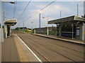
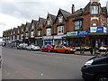
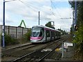
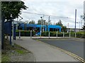
Residents of B21 0BL have access to a range of nearby amenities, including five retail outlets such as Lidl Handsworth, Farmfoods Handsworth, and Iceland Handsworth, which provide everyday shopping options. The area is also served by five metro stations, including Handsworth Booth Street and Winson Green Outer Circle, as well as five rail stations like Hawthorns Railway Station and Smethwick Rolfe Street Railway Station. These transport links facilitate both local and regional travel, enhancing accessibility to employment, leisure, and services. While the data does not specify parks or leisure facilities, the presence of multiple retail and transport hubs suggests a functional, practical lifestyle. The combination of shopping, transport, and connectivity options supports a self-contained daily routine, though the area’s small size may limit the diversity of amenities available. For residents, this balance of convenience and practicality defines the lifestyle in B21 0BL.
Amenities
Schools
The nearest schools to B21 0BL include Holyhead School, which operates as both a primary school and an academy with a good Ofsted rating. The presence of a primary school suggests that the area is suitable for families with younger children, though the absence of secondary schools nearby may require commuting. The academy’s good rating indicates a standard of education that meets regulatory benchmarks, though specific details about curriculum or performance metrics are not provided. The mix of school types—primary and academy—offers a range of educational options, though the lack of secondary provision could be a limitation for families requiring a full spectrum of schooling. For prospective buyers, the availability of a rated primary school is a positive factor, but the need to travel for secondary education may influence decisions about proximity to other schools in the region.
| Rank | School | Type | Entry gender | Ages |
|---|
Explore more schools in this area
Go to Schools tabDemographics
The population of B21 0BL is 1559, with a median age of 47. The majority of residents fall within the 30–64 age range, suggesting a community dominated by working-age adults and older professionals. Home ownership in the area is relatively low at 33%, indicating that a significant proportion of properties are rented. This could reflect a mix of long-term residents and transient occupants, or a reliance on rental housing due to local economic factors. The predominant ethnic group is listed as Asian_total, though specific subgroups are not detailed. The accommodation type is primarily houses, which is unusual for areas with high rental rates, implying a potential disconnect between housing stock and demand. The low home ownership rate may also influence the area’s social dynamics, with fewer long-term residents compared to owner-occupied neighbourhoods. For prospective buyers, this data highlights a community with a mature age profile and a rental-focused housing market, which may affect property value trends and local amenities.
Household Size
Accommodation Type
Tenure
Ethnic Group
Religion
Household Composition
Age
Household Deprivation
NS-SEC
Explore more demographic insights in this area
Go to Demographics tabPlanning
Planning Constraints
- Flood RiskPremium
- Ramsar Wetland SitesPremium
- Area of Outstanding Natural BeautyPremium
- Protected Nature ReservePremium
- Protected WoodlandPremium