Area Overview for B20 3TZ
Photos of B20 3TZ
Area Information
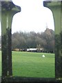
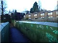
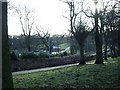
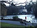
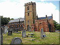
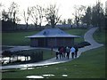
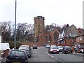
Birchfield is an inner city electoral ward situated in the Perry Barr constituency of Birmingham. You will find this specific residential cluster at postcode B20 3TZ north of the city centre in the West Midlands region. This locality encompasses approximately 1,641 residents and forms part of a larger ward population of 12,473. The area developed during the 19th century as Birmingham expanded, featuring terraced housing and local estates. Local history connects the area to the first official game of Aston Villa Football Club in 1875 on Wilson Road and the formation of the Birchfield Harriers athletics club in 1877. You can explore the Birchfield Heritage Trail to understand the diverse cultural history of the neighbourhood. Notable local sites include Hollick & Taylor, which holds the distinction of being Birmingham's oldest operational recording studio established post-1945. The Vale local shopping centre serves as a convergence point for five different roads. Birchfield House stands as a historic property that was once the home of clock-dial maker Samuel Wilkes. Its gardens opened to the public in 1849. Living in B20 3TZ means accessing these established landmarks within a community that has grown from a 6th-century settlement originally established by the Beormingas. The area boasts significant urban growth stemming from a market charter granted in 1166.
- Area Type
- Postcode
- Area Size
- Not available
- Population
- 1641
- Population Density
- Not available
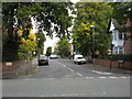
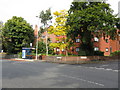
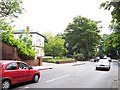
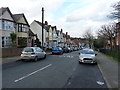
The property market in B20 3TZ is characterised by a significant proportion of owner-occupied homes. With 62% of households in the area being owner-occupied, you are more likely to find established families and long-term residents than transient tenants. The predominant accommodation type is houses, meaning the streetscape will feature detached or semi-detached properties rather than high-rise blocks or terraced rows found elsewhere. This housing stock often appeals to those seeking space and stability within an urban setting. When looking at homes in B20 3TZ, you are entering a market where ownership is the norm. This stability often correlates with well-maintained properties and a sense of community investment in local improvements. Buyers here should expect a range of house styles reflecting the area's 19th-century development and subsequent growth. The high concentration of owners suggests that price values may be influenced by long-standing property improvements rather than rapid turnover. While specific property price listings are not detailed in this overview, the ownership pattern indicates a traditional residential market. You might find older homes that have been extended or renovated by current owners over previous decades. This contrasts with areas where rental inventories dominate the landscape.
House Prices in B20 3TZ
No properties found in this postcode.
Energy Efficiency in B20 3TZ
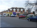
Your daily lifestyle in B20 3TZ benefits from several retail and transport hubs located within practical reach. You have access to five retail venues, including M&S Perry, Iceland Perry, and Asda Perry, ensuring convenient shopping without needing to travel far. Five railway stations, such as Perry Barr Railway Station and Hamstead Railway Station, are nearby, offering straightforward rail access to wider Birmingham. The metro network is equally close, with stops including Soho Benson Road, Winson Ground Outer Circle, and Handsworth Booth Street providing further transport flexibility. This density of services means you can complete most weekly chores close to home. The area's history influences its character, with sites like the Vale local shopping centre acting as a central convergence point. Historical landmarks like Birchfield House and Hollick & Taylor recording studios add cultural depth to your local environment. Sports enthusiasts may appreciate the proximity to Alexander Stadium, which was built in 1927 and serves the Birchfield Harriers athletics club. The Birchfield Heritage Trail also highlights diverse cultural history for visitors and locals alike. With five metro stations nearby, commuting into the city centre is manageable. Living in B20 3TZ provides a balance of urban convenience and historical charm without the overwhelming pace of the city centre itself.
Amenities
Schools
| Rank | School | Type | Entry gender | Ages |
|---|
Explore more schools in this area
Go to Schools tabDemographics
The community in B20 3TZ reflects a mature demographic profile with a median age of 47 years. Adults aged between 30 and 64 years represent the most common age range within this specific locality. You will find that 62% of households here are owner-occupied, indicating a stable resident population with a strong commitment to the area. The predominant accommodation type consists of houses rather than flats or terraced blocks. These homes provide the setting for families and professionals who have settled into long-term residences. The area is also marked by diversity, with the Asian_total ethnic group forming the predominant ethnic group within the community. This demographic character contributes to the cultural fabric of Birchfield. While the median age suggests a quieter environment compared to newer student-dominated zones, the presence of working-age adults ensures local vibrancy. The home ownership rate of 62% is notably high, suggesting that many residents have invested significantly in their local properties. This statistic informs the stability of the neighbourhood and suggests fewer frequent movers compared to areas with lower ownership rates. When considering homes in B20 3TZ, you are looking into an environment where established residents have shaped the local atmosphere.
Household Size
Accommodation Type
Tenure
Ethnic Group
Religion
Household Composition
Age
Household Deprivation
NS-SEC
Explore more demographic insights in this area
Go to Demographics tabPlanning
Planning Constraints
- Flood RiskPremium
- Ramsar Wetland SitesPremium
- Area of Outstanding Natural BeautyPremium
- Protected Nature ReservePremium
- Protected WoodlandPremium
- Crime RiskPremium