Area Overview for B20 3DJ
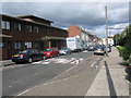
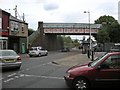
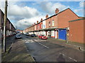
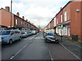
Photos of B20 3DJ


Area Information
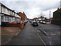
Living in B20 3DJ, a small residential cluster in north-east Birmingham, means being part of a compact, historically significant ward with a population of 1,738. The area, formed in 1911 after Birmingham’s expansion, reflects a blend of late 19th- and early 20th-century terraced housing, some of which was disrupted by the 1960s Aston Expressway. Despite past challenges, including deprivation in the 1980s, regeneration efforts like the “Aston Pride” project from 2001–2011 have reshaped the district. Today, it is a mixed community with a median age of 47, where adults aged 30–64 form the largest demographic. The area’s proximity to major transport routes, including the Aston Expressway and Spaghetti Junction, ensures connectivity, while its history of industrial activity, such as Premier Motor Works, adds to its character. Residents benefit from a range of local amenities, though the area’s small size means services are concentrated within a short reach. For those seeking a balance between urban convenience and historical roots, B20 3DJ offers a distinct, compact living experience.
- Area Type
- Postcode
- Area Size
- Not available
- Population
- 1738
- Population Density
- 9100 people/km²
The property market in B20 3DJ is defined by a 40% home ownership rate, indicating that a majority of properties are likely rented. The area’s accommodation type is primarily houses, which contrasts with the prevalence of flats in larger urban centres. This suggests a more traditional housing stock, potentially appealing to families or those seeking larger living spaces. However, the small size of the postcode area means the housing stock is limited, and buyers may need to consider nearby districts for more options. The 40% ownership rate also implies a rental market that could offer investment opportunities, though competition for properties may be keen. Given the area’s regeneration history, some housing may have been modernised, though the presence of older terraced homes suggests a mix of property conditions. For buyers, the compact nature of B20 3DJ means proximity to amenities is a key advantage, though the limited supply of houses could make the market competitive.
House Prices in B20 3DJ
No properties found in this postcode.
Energy Efficiency in B20 3DJ
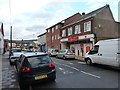
The lifestyle in B20 3DJ is shaped by its proximity to retail, transport, and urban infrastructure. Residents have access to five retail outlets, including Iceland Perry, Asda Perry, and Tesco Aston, providing everyday shopping convenience. The area’s rail network, with stations such as Perry Barr and Witton, ensures easy travel to Birmingham’s business districts and beyond. Five metro stops, including St Paul’s and St Chads, add to the transport options, supporting both daily commutes and leisure trips. While the area lacks large parks or green spaces, its location near the Aston Expressway and major roads offers connectivity to broader urban amenities. The compact nature of B20 3DJ means that amenities are concentrated within a short walk or drive, fostering a sense of convenience. However, the absence of detailed data on leisure or recreational facilities suggests that residents may need to venture further for activities such as dining or cultural events. Overall, the area’s practicality and accessibility make it suitable for those prioritising transport links and retail convenience.
Amenities
Schools
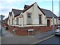
Residents of B20 3DJ have access to several schools, including Canterbury Cross Primary School and Sacred Heart Catholic School, both of which are primary institutions. Sacred Heart Catholic School also operates as an academy with a satisfactory Ofsted rating, indicating a moderate standard of education. The Institute of Higher Excellence is an independent school, offering an alternative to state education. The mix of state and independent schools provides families with choices, though the presence of only primary schools suggests that secondary education options may be located further afield. The Ofsted rating for Sacred Heart as satisfactory highlights that while the school meets basic standards, there may be room for improvement in areas such as academic outcomes or student support. For families prioritising school quality, the availability of an independent school could be a significant factor, though the overall range of educational options is limited within the immediate area.
| Rank | School | Type | Entry gender | Ages |
|---|
Explore more schools in this area
Go to Schools tabDemographics
The community in B20 3DJ is predominantly composed of adults aged 30–64, with a median age of 47. Home ownership sits at 40%, suggesting a mix of owner-occupied and rental properties. The area is characterised by houses rather than flats, reflecting a traditional housing stock. The predominant ethnic group is the Asian_total category, a legacy of post-war immigration from the Indian subcontinent and the Caribbean. While the data does not specify deprivation levels, the area’s regeneration history indicates improvements in quality of life. The presence of diverse age groups and ethnic backgrounds contributes to a dynamic, albeit small, social fabric. With 1,738 residents, the community is tightly knit, though the limited population size means local services and amenities are concentrated within a short radius. This demographic profile suggests a stable, mature population with established ties to the area, though the 40% home ownership rate implies a significant portion of residents may be renting, potentially affecting long-term stability for some households.
Household Size
Accommodation Type
Tenure
Ethnic Group
Religion
Household Composition
Age
Household Deprivation
NS-SEC
Explore more demographic insights in this area
Go to Demographics tabPlanning
Planning Constraints
- Flood RiskPremium
- Ramsar Wetland SitesPremium
- Area of Outstanding Natural BeautyPremium
- Protected Nature ReservePremium
- Protected WoodlandPremium