Area Overview for B20 2SL
Photos of B20 2SL


Area Information
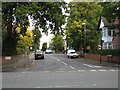
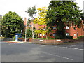
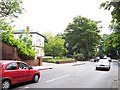
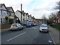
B20 2SL is a small, defined postcode area in England, home to 1,631 residents. Situated in the Handsworth district, it lies approximately 2 kilometres north of Birmingham City Centre, blending suburban tranquillity with proximity to urban amenities. Historically, the area was distinguished as a separate entity from Handsworth, marked by its large, spacious properties on substantial plots. Today, it retains a suburban character, with low-density development and a village-like feel. The area’s appeal lies in its mix of historical roots and modern convenience, from its 19th-century railway heritage to contemporary digital connectivity. Residents benefit from easy access to Birmingham’s cultural and economic hubs while enjoying a quieter, more residential environment. The demographic profile reflects a mature community, with a median age of 47 and a strong presence of households in the 30–64 age range. This makes B20 2SL a stable, family-oriented area with a distinct identity, shaped by its past as a rural retreat for Birmingham’s elite and its continued role as a suburban suburb.
- Area Type
- Postcode
- Area Size
- Not available
- Population
- 1631
- Population Density
- 5157 people/km²
B20 2SL is characterised by a housing stock that leans heavily towards owner-occupied properties, with 46% of residents owning their homes. The accommodation type is predominantly houses, reflecting the area’s suburban nature and historical development as a place for larger, spacious residences. This contrasts with more densely populated urban areas, where flats are more common. The presence of houses on substantial plots suggests that the area is less suited to short-term rental markets and more aligned with long-term homeownership. For buyers, this means a focus on individual properties rather than multi-unit developments. The small size of the postcode area means that the immediate surroundings are likely to mirror this pattern, with limited scope for high-density housing. Potential buyers should consider the area’s appeal to families and professionals seeking space, though the 46% home ownership rate indicates that a significant portion of the housing stock may be available for purchase or rental.
House Prices in B20 2SL
No properties found in this postcode.
Energy Efficiency in B20 2SL
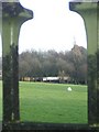
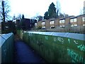
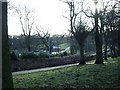
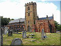
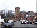
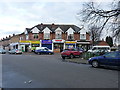
Living in B20 2SL offers access to a range of local amenities, including retail outlets such as Tesco Handsworth, M&S Perry, and Iceland Perry. These shops provide everyday essentials, supporting a self-contained lifestyle. The area’s transport network, with multiple railway and metro stations, ensures easy access to Birmingham’s cultural and commercial hubs. For leisure, residents can visit Handsworth Park, a significant local landmark with historical and recreational value. The park includes formal gardens and a Sunken Garden, offering green space for relaxation. Nearby, St Mary’s Church and the Old Town Hall on College Road provide a link to the area’s heritage. These amenities contribute to a balanced lifestyle, combining modern convenience with historical charm. The presence of retail, transport, and green spaces suggests a community that values both practicality and quality of life.
Amenities
Schools
The nearest school to B20 2SL is St Teresa’s Catholic Primary School, which serves the local community with a primary education offering. It holds an Ofsted rating of ‘good’, indicating a satisfactory standard of teaching and facilities. The presence of a primary school suggests that the area is well-suited for families with young children, though no secondary schools are listed in the data. This means that students may need to travel to nearby areas for secondary education, potentially affecting commuting times. The availability of a primary school with a positive rating is a key consideration for families prioritising quality education. However, the absence of secondary schooling within the immediate vicinity highlights the importance of proximity to other educational institutions when evaluating the area for long-term residence.
| Rank | A + A* % | School | Type | Entry gender | Ages |
|---|---|---|---|---|---|
| 1 | N/A | St Teresa's Catholic Primary School | primary | N/A | N/A |
Explore more schools in this area
Go to Schools tabDemographics
The population of B20 2SL is 1,631, with a median age of 47, indicating a mature community. The majority of residents fall within the 30–64 age range, suggesting a mix of established families and professionals. Home ownership is at 46%, slightly below the national average, with accommodation predominantly comprising houses rather than flats. The predominant ethnic group is Asian_total, reflecting a culturally diverse yet cohesive community. This demographic profile implies a stable, long-term resident base with a focus on family living. The absence of specific deprivation data means that quality of life is likely influenced by the area’s amenities and infrastructure. With a significant proportion of the population in middle age, the community may prioritise services such as healthcare, education, and local amenities. The mix of home ownership and rental properties suggests a balance between long-term residents and those seeking housing in a suburban setting.
Household Size
Accommodation Type
Tenure
Ethnic Group
Religion
Household Composition
Age
Household Deprivation
NS-SEC
Explore more demographic insights in this area
Go to Demographics tabPlanning
Planning Constraints
- Flood RiskLocked
- Ramsar Wetland SitesLocked
- Area of Outstanding Natural BeautyLocked
- Protected Nature ReserveLocked
- Protected WoodlandLocked
- Crime RiskLocked