Area Overview for B19 3SD
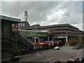
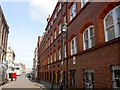
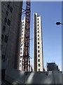
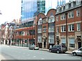
Photos of B19 3SD


Area Information
Living in B19 3SD means being part of a densely populated, inner-city postcode in Birmingham’s Newtown Ward. The area covers just 1.1 hectares, housing 2,226 people in a compact residential cluster. Centred on New Town Row, a section of the A34 road, it lies within Birmingham’s ring-road network, linking to the city centre and surrounding districts. The postcode is part of Aston New Town, a post-war redevelopment project that replaced slum housing with tower blocks and multi-storey flats. Today, the area is defined by its compact layout and proximity to key transport routes. Residents benefit from nearby rail stations, including Birmingham Snow Hill and Jewellery Quarter, as well as multiple retail hubs. The community is young, with a median age of 22, and reflects a diverse demographic, particularly among Black residents. Daily life here is shaped by the urban environment, with a focus on accessibility and connectivity. While the area’s history includes large-scale redevelopment, its current character blends practical living with the vibrancy of a city ward.
- Area Type
- Postcode
- Area Size
- 1.1 hectares
- Population
- 2226
- Population Density
- 4221 people/km²
The property market in B19 3SD is characterised by a 15% home ownership rate, meaning the vast majority of residents rent their homes. The accommodation type is predominantly flats, a legacy of the 1960s redevelopment that created a large estate of tower blocks. This suggests a housing stock that is largely purpose-built, with limited scope for private house purchases. The area’s small size—just 1.1 hectares—means the available housing is concentrated, often in multi-storey buildings. For buyers, this implies a focus on rental properties rather than owner-occupied homes. The flat-dominated market may appeal to those seeking affordable, centrally located living, but it also means competition for limited housing stock. Proximity to transport links and schools may offset the lack of traditional housing options. However, the high population density and rental focus suggest that property values are unlikely to rise significantly, making it a pragmatic choice for those prioritising location over long-term investment.
House Prices in B19 3SD
Showing 7 properties
| Address | Type | Beds | Baths | Last Sale Price | Last Sale Date | |
|---|---|---|---|---|---|---|
| Part First Floor, 16 Summer Lane, Aston, Birmingham, B19 3SD | Office | - | - | - | - | |
| Hpas Ltd, Part Ground Floor, 16 Summer Lane, Aston, Birmingham, B19 3SD | Office | - | - | - | - | |
| Centro Plc, Basement Part Ground And First To Fourth Floors, 16 Summer Lane, Aston, Birmingham, B19 3SD | office_workshop | - | - | - | - | |
| Birmingham City Council Part Fifth Floor, 16 Summer Lane, Aston, Birmingham, B19 3SD | Office | - | - | - | - | |
| Sixth Floor, 16 Summer Lane, Aston, Birmingham, B19 3SD | Office | - | - | - | - | |
| Wmtis Part Fifth Floor, 16 Summer Lane, Aston, Birmingham, B19 3SD | Office | - | - | - | - | |
| Seventh Floor, 16 Summer Lane, Aston, Birmingham, B19 3SD | Office | - | - | - | - |
Energy Efficiency in B19 3SD
The lifestyle in B19 3SD is shaped by its urban setting and proximity to essential amenities. Residents have access to five metro stops, five rail stations, and five retail outlets, including Co-op Colmore and Tesco Bagot, ensuring daily needs are met with ease. The area’s character is defined by its post-war tower block estate, but this is balanced by practical convenience. The nearby St George’s Church of England Academy and Arc Oakbridge School provide educational opportunities, while the dense transport network supports both work and leisure. The compact layout means short commutes to Birmingham’s city centre, and the presence of multiple retail hubs reduces the need for long trips. While the area lacks green spaces, its focus on accessibility and connectivity makes it ideal for those prioritising efficiency. The mix of transport, shopping, and education options creates a functional urban lifestyle, though residents may seek additional recreational spaces outside the immediate area.
Amenities
Schools
Residents of B19 3SD have access to a range of primary schools, including St George’s CofE Junior and Infant School and St George’s CofE School, both of which serve younger children. For older students, St George’s Church of England Academy, Newtown is an academy with a good Ofsted rating, offering secondary education. Additionally, Arc Oakbridge School, a special needs school with a good Ofsted rating, provides tailored education for students with specific requirements. The mix of school types ensures that families have options for both mainstream and specialist education. The presence of multiple schools within the area suggests a focus on local provision, reducing the need for long commutes. However, the absence of higher education institutions nearby means students may need to travel for university. The good Ofsted ratings indicate that the schools meet quality standards, though parents should consider individual school performance and availability of places.
| Rank | School | Type | Entry gender | Ages |
|---|
Explore more schools in this area
Go to Schools tabDemographics
B19 3SD has a median age of 22, with the majority of residents aged 15–29. This makes it a predominantly young adult community, likely shaped by student populations or early-career professionals. Only 15% of homes are owner-occupied, indicating a rental-dominated market. The accommodation type is primarily flats, reflecting the post-war tower block legacy. The predominant ethnic group is Black residents, highlighting the area’s cultural diversity. With a population density of 206,936 people per square kilometre, the community is tightly packed, which can influence social dynamics and access to shared spaces. The high proportion of renters and young residents suggests a transient population, potentially affecting local amenities and services. This density also means proximity to transport and retail, but may limit private outdoor space. The demographic profile indicates a need for housing that caters to young, mobile residents, with a focus on affordability and convenience.
Household Size
Accommodation Type
Tenure
Ethnic Group
Religion
Household Composition
Age
Household Deprivation
NS-SEC
Explore more demographic insights in this area
Go to Demographics tabPlanning
Planning Constraints
- Flood RiskPremium
- Ramsar Wetland SitesPremium
- Area of Outstanding Natural BeautyPremium
- Protected Nature ReservePremium
- Protected WoodlandPremium