Area Overview for B19 3RL
Photos of B19 3RL
Area Information
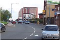
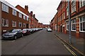
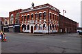
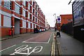
Living in B19 3RL means residing in a small, tightly knit residential cluster within Birmingham’s Newtown Ward, a historically redeveloped inner-city area. With a population of 1,584, this postcode is part of a larger district centred on New Town Row, a section of the A34 road. The area is bordered by the Jewellery Quarter, the Gun Quarter, and the University of Aston, placing it at the heart of Birmingham’s industrial and academic corridors. Post-war redevelopment transformed the district into a cluster of tower blocks and multi-storey flats, a legacy visible in its housing stock. The community is young, with a median age of 22, though the most common age range is adults aged 30–64. This mix of demographics reflects a dynamic, working-age population, often drawn to the area’s proximity to transport hubs and employment opportunities.
- Area Type
- Postcode
- Area Size
- Not available
- Population
- 1584
- Population Density
- 11054 people/km²
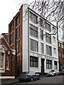
The property market in B19 3RL is characterised by a low home ownership rate of 12%, indicating that the majority of residents rent their homes. The accommodation type is predominantly flats, a direct result of the area’s post-war redevelopment into a tower block estate. This housing stock, while functional, reflects the legacy of 1960s urban planning, with multi-storey blocks dominating the landscape. For buyers, the small area and limited housing stock mean that owner-occupied properties are rare, and the market is largely geared toward renters. The focus on flats also suggests that the area may not appeal to those seeking larger homes or traditional housing. Prospective buyers should consider the limited availability of owner-occupied properties and the potential for long-term rental commitments.
House Prices in B19 3RL
No properties found in this postcode.
Energy Efficiency in B19 3RL
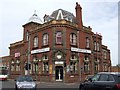
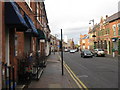
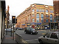
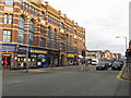
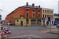
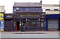
The lifestyle in B19 3RL is shaped by its proximity to a variety of amenities. Residents have access to five retail outlets, including Morrisons Select and Tesco Bagot, ensuring everyday shopping needs are met. The area’s metro stations—St Paul’s, St Chads, and Bull Street—offer easy access to local services and public transport. Rail stations such as Birmingham Snow Hill and Jewellery Quarter provide connections to broader networks. While the area’s character is defined by its post-war tower blocks, the availability of nearby shops, transport hubs, and community facilities ensures a practical, convenient lifestyle. The mix of retail, dining, and transport options supports a functional daily life, though the absence of green spaces or leisure facilities may be a drawback for some.
Amenities
Schools
Residents of B19 3RL have access to a range of educational institutions, including Brearley Nursery School, which provides early years education, and St Chad’s Catholic Primary School, which has an Ofsted rating of ‘good’. The presence of both a nursery and a primary school within the area offers families convenience and continuity in their children’s education. The ‘good’ rating at St Chad’s indicates that the school meets high standards in teaching and student outcomes. However, the absence of secondary schools in the immediate vicinity means that families may need to consider nearby districts for secondary education. The mix of school types suggests a focus on early and primary education, which is crucial for young families in the area.
| Rank | School | Type | Entry gender | Ages |
|---|
Explore more schools in this area
Go to Schools tabDemographics
B19 3RL has a median age of 22, but the most common age group is adults aged 30–64, indicating a mature working population. Only 12% of residents own their homes, suggesting a rental-dominated market. The area’s accommodation is predominantly flats, a legacy of post-war redevelopment. The predominant ethnic group is Black_total, reflecting the area’s historical ties to migration and industrial employment. While home ownership is low, the population density and flat-based housing suggest a community focused on affordability and proximity to services. This demographic profile aligns with the broader Newtown Ward, which has a population of around 16,289, making it one of Birmingham’s more populous areas.
Household Size
Accommodation Type
Tenure
Ethnic Group
Religion
Household Composition
Age
Household Deprivation
NS-SEC
Explore more demographic insights in this area
Go to Demographics tabPlanning
Planning Constraints
- Flood RiskPremium
- Ramsar Wetland SitesPremium
- Area of Outstanding Natural BeautyPremium
- Protected Nature ReservePremium
- Protected WoodlandPremium