Area Overview for B19 3RA
Photos of B19 3RA


Area Information
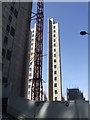
Living in B19 3RA means being part of a small, tightly knit residential cluster in the Newtown Ward of Birmingham. With a population of 2,226, the area is compact but layered with history. Originally developed as part of post-war redevelopment, it features a mix of modern infrastructure and inner-city character. The area is centred on New Town Row, a section of the A34 road, and sits near the A4540 ring-road, placing it within reach of Birmingham’s broader network. Young adults dominate the population, with the median age at 22, reflecting a dynamic, often transient community. This is a place where rental flats outnumber owner-occupied homes, and the social fabric is shaped by a diverse demographic, with the Black population forming the largest group. Daily life here balances proximity to city amenities with the practical realities of urban living, where transport links and retail options are within walking distance. For those seeking a blend of affordability and accessibility, B19 3RA offers a snapshot of Birmingham’s evolving urban landscape.
- Area Type
- Postcode
- Area Size
- Not available
- Population
- 2226
- Population Density
- 4221 people/km²
The property market in B19 3RA is almost entirely rental-based, with only 15% of homes owned by residents. The area is dominated by flats, a legacy of its post-war redevelopment into tower blocks and multi-storey housing. This means the housing stock is largely uniform, with limited scope for owner-occupation or property investment. For buyers, this suggests a market where opportunities are scarce, and competition for available homes may be intense. The small size of the postcode area and its proximity to Birmingham’s ring-roads mean that property seekers might need to look beyond B19 3RA to find a broader range of options. However, the presence of nearby rail and road networks could make the area appealing for those prioritising connectivity over property diversity.
House Prices in B19 3RA
No properties found in this postcode.
Energy Efficiency in B19 3RA
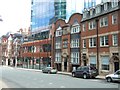
The lifestyle in B19 3RA is shaped by its proximity to a variety of amenities. Within walking distance are metro stops like St Paul’s and Bull Street, offering easy access to Birmingham’s transport network. Retail options include Morrisons Select, Morrisons Daily, and Tesco Birmingham, ensuring daily shopping needs are met. The area’s rail connections, including Birmingham Snow Hill and Jewellery Quarter stations, provide links to the wider city. While parks and green spaces are not explicitly listed in the data, the area’s character is defined by its urban infrastructure and social hubs. The presence of pubs like The Bartons Arms and venues such as The Drum Arts Centre suggests a community with a mix of leisure and cultural activities. For residents, the blend of transport, retail, and connectivity creates a convenient, if compact, urban lifestyle.
Amenities
Schools
Residents of B19 3RA have access to a range of schools, including St George’s CofE Junior and Infant School and St George’s CofE School, both primary institutions. For secondary education, St George’s Church of England Academy, Newtown is an academy with a good Ofsted rating, offering a broader curriculum. Additionally, Arc Oakbridge School, a special school with a good rating, caters to students with specific educational needs. This mix of primary, secondary, and special schools provides families with options tailored to different stages of education and requirements. The presence of a special school underscores the area’s commitment to inclusive education, while the academy’s good rating suggests a focus on academic standards. Parents seeking a variety of school types within walking distance will find B19 3RA well served.
| Rank | School | Type | Entry gender | Ages |
|---|
Explore more schools in this area
Go to Schools tabDemographics
The community in B19 3RA is defined by its youthful profile, with a median age of 22 and the most common age range being 15–29 years. Just 15% of residents own their homes, indicating a rental-dominated market. The accommodation type is predominantly flats, reflecting the area’s post-war redevelopment into tower blocks and multi-storey housing. The Black population is the largest ethnic group, contributing to the area’s cultural diversity. While specific data on deprivation is not provided, the high proportion of renters and young residents suggests a community shaped by affordability and mobility. This demographic mix influences local dynamics, with a focus on transient living and shared spaces. The low home ownership rate also points to limited long-term investment in property, which may affect both property values and the character of the neighbourhood.
Household Size
Accommodation Type
Tenure
Ethnic Group
Religion
Household Composition
Age
Household Deprivation
NS-SEC
Explore more demographic insights in this area
Go to Demographics tabPlanning
Planning Constraints
- Flood RiskPremium
- Ramsar Wetland SitesPremium
- Area of Outstanding Natural BeautyPremium
- Protected Nature ReservePremium
- Protected WoodlandPremium