Area Overview for B19 3PZ
Photos of B19 3PZ


Area Information
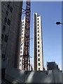
Living in B19 3PZ means being part of a small residential cluster in the heart of Birmingham’s Newtown Ward, a historically redeveloped inner-city area. With a population of 2,226, this postcode reflects a community shaped by post-war urban renewal. The area is centred on New Town Row, a stretch of the A34 road, and bordered by districts like the Jewellery Quarter and Aston. Its character is defined by high-rise flats, a legacy of 1960s redevelopment that replaced slum housing with tower blocks. Today, the area is home to a young demographic, with the median age at 22 and most residents aged 15–29. This makes B19 3PZ a hub for students, young professionals, and families seeking affordable housing in a city with strong transport links. The proximity to Birmingham’s central amenities, combined with a mix of flats and rental properties, creates a dynamic, though compact, urban environment.
- Area Type
- Postcode
- Area Size
- Not available
- Population
- 2226
- Population Density
- 4221 people/km²
The property market in B19 3PZ is dominated by flats, with no significant presence of owner-occupied homes. Only 15% of residents are homeowners, indicating that the area is primarily a rental market. This is consistent with its history as a post-war redevelopment site, where high-rise blocks were built to accommodate growing populations. The limited number of homes for sale suggests that buyers seeking private property may find few options within the postcode itself. However, the surrounding areas, including parts of Aston and Lozells, offer more varied housing. For those considering the area, the focus should be on rental properties, particularly flats within the tower block estates. The compact nature of B19 3PZ means that proximity to transport and amenities is key, making it appealing for commuters but less suitable for those seeking larger or more traditional homes.
House Prices in B19 3PZ
No properties found in this postcode.
Energy Efficiency in B19 3PZ
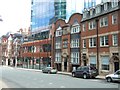
Life in B19 3PZ is defined by convenience and accessibility. Within walking distance are five retail outlets, including Morrisons Daily, Tesco Birmingham, and Co-op Colmore, offering everyday shopping needs. The area’s metro and rail stations provide easy access to Birmingham’s cultural and commercial hubs, while nearby landmarks like The Bartons Arms and The Drum Arts Centre add a social dimension. The inner-city setting means green spaces are limited, but the proximity to the A34 and A4540 roads ensures quick travel to parks and recreational areas in surrounding districts. The mix of retail, transport, and social venues creates a functional lifestyle, ideal for those prioritising connectivity over expansive outdoor spaces. However, the compact nature of the area means that residents may need to venture further for larger leisure opportunities. The combination of practical amenities and urban convenience makes B19 3PZ a viable choice for those seeking a central, well-serviced location.
Amenities
Schools
Residents of B19 3PZ have access to a range of schools, including primary and special needs institutions. St George’s CofE Junior and Infant School and St George’s CofE School cater to younger children, while St George’s Church of England Academy, Newtown is an academy with a ‘good’ Ofsted rating. Arc Oakbridge School, a special needs school, also holds a ‘good’ rating. This mix of school types provides options for families with varying educational needs, from mainstream primary education to support for students with specific requirements. The presence of two primary schools and a special school within a short distance suggests that the area is well-served for families with children. However, the absence of secondary schools nearby may require commuting to other parts of Birmingham. The Ofsted ratings indicate that the local education provision meets acceptable standards, though parents may need to consider additional factors like school catchment areas.
| Rank | School | Type | Entry gender | Ages |
|---|
Explore more schools in this area
Go to Schools tabDemographics
The community in B19 3PZ is predominantly young, with a median age of 22 and the most common age range being 15–29 years. Only 15% of residents own their homes, reflecting a rental-dominated market. The accommodation type is almost exclusively flats, a legacy of the area’s post-war redevelopment. The predominant ethnic group is Black, which shapes the cultural and social fabric of the neighbourhood. This demographic profile suggests a transient population, with many residents likely to be students or young workers. The low home ownership rate indicates limited long-term investment in property, and the age distribution points to a community focused on short-term living or entry-level housing. The area’s character as an inner-city renewal zone means it lacks the traditional housing stock of older districts, prioritising density over individual homes.
Household Size
Accommodation Type
Tenure
Ethnic Group
Religion
Household Composition
Age
Household Deprivation
NS-SEC
Explore more demographic insights in this area
Go to Demographics tabPlanning
Planning Constraints
- Flood RiskPremium
- Ramsar Wetland SitesPremium
- Area of Outstanding Natural BeautyPremium
- Protected Nature ReservePremium
- Protected WoodlandPremium